Costa Rica claim on the exclusive economic zone in the Pacific Ocean

Costa Rica claim on the exclusive economic zone in the Pacific Ocean, costa rica, Costa Rica claim on the exclusive economic zone, Costa Rica Maritime claims, Marine Regions Costa Rican Exclusive Economic Zone (EEZ), Maritime Claims, Pacific Ocean

View More Costa Rica claim on the exclusive economic zone in the Pacific Ocean

Republic of Congo claims on baselines for measuring the breadth of the territorial sea, contiguous zone and exclusive economic zone

Republic of Congo claims on baselines for measuring the breadth of the territorial sea, contiguous zone and exclusive economic zone, Congo, Congo claims on baselines, Congo maritime claims, DRC and Angolan maritime and oil boundaries, Maritime Claims, Republic of the Congo Maritime claims

View More Republic of Congo claims on baselines for measuring the breadth of the territorial sea, contiguous zone and exclusive economic zone

China claims on the Baselines of the Territorial Sea of Diaoyu Dao and its Affiliated Islands

China claims on the Baselines of the Territorial Sea of Diaoyu Dao and its Affiliated Islands, china base line coordinates, China claims on the Baselines, china territorial disputes, Maritime Claims, maritime zone of china, Sea of Diaoyu Dao

View More China claims on the Baselines of the Territorial Sea of Diaoyu Dao and its Affiliated Islands

Delimitation of the Territorial Sea, the Exclusive Economic Zone and Continental Shelf in Beibu Bay between China and Vietnam

Delimitation of the Territorial Sea, the Exclusive Economic Zone and Continental Shelf in Beibu Bay between China and Vietnam, Beibu Bay, China, delimitation, Maritime Boundary Delimitation and SinoVietnamese Cooperation in the Gulf of Tonkin (1994-2016), Maritime Claims, specified in the Agreement between the People’s Republic of China and the Socialist Republic of Viet Nam, Vietnam

View More Delimitation of the Territorial Sea, the Exclusive Economic Zone and Continental Shelf in Beibu Bay between China and Vietnam

Baselines of the Territorial Sea of the People’s Republic of China that claimed in 1996

Baselines of the Territorial Sea of the People’s Republic of China that claimed in 1996, Baselines of the Chinese territorial sea, China, China Boundaries Maps, China Straight Baselines, China’s claimed straight baselines., China’s Straight Baseline Claim, Maritime Claims, maritime zone of china, Offshore Archipelagos Enclosed by Straight Baselines, Territorial waters China Maps

View More Baselines of the Territorial Sea of the People’s Republic of China that claimed in 1996

charts showing normal and straight baselines, the territorial sea, the contiguous zone, the exclusive economic zone and the continental shelf of Chile

charts showing normal and straight baselines, the territorial sea, the contiguous zone, the exclusive economic zone and the continental shelf of Chile, peru-chile maritime border dispute pdf, Punta Lengua de Vaca a Isla Guafo, Punta Puga a Islas Diego Ramirez, Rada de Arica a Caleta Matanza, The Maritime Dispute Between Peru and Chile

View More charts showing normal and straight baselines, the territorial sea, the contiguous zone, the exclusive economic zone and the continental shelf of Chile

chart showing the maritime boundary between Argentina and Chile, with the list of geographical coordinates of points

chart showing the maritime boundary between Argentina and Chile, with the list of geographical coordinates of points, argentina, chile, exclusive economic zone, maritime boundary between Argentina and Chile, Maritime Claims

View More chart showing the maritime boundary between Argentina and Chile, with the list of geographical coordinates of points

Brazil claims on the Baselines for measuring the breadth of the territorial sea and Outer limit of the Exclusive Economic Zone

Brazil claims on the Baselines for measuring the breadth of the territorial sea and Outer limit of the Exclusive Economic Zone, Brazil, Brazilian continental shelf expansion: widening the outer edge, Brazilian EEZ expansion: widening the outer edge, Exclusive economic zone of Brazil, Map of the Brazilian coast, Maritime Claims, The Continental Shelf of Brazil

View More Brazil claims on the Baselines for measuring the breadth of the territorial sea and Outer limit of the Exclusive Economic Zone

Belgium claims for outer limit lines of the continental shelf and territorial sea

Belgium claims for outer limit lines of the continental shelf and territorial sea, Belgium, Belgium Maritime claims, continental shelf, Maritime Claims

View More Belgium claims for outer limit lines of the continental shelf and territorial sea

Bangladesh claims for straight baselines in measuring the breadth of the territorial sea

Bangladesh claims for straight baselines in measuring the breadth of the territorial sea, bangladesh, bangladesh maritime boundary map, Bangladesh sea area map, Maritime Boundary of Bangladesh, Maritime Claims, The Bangladesh Maritime Zones

View More Bangladesh claims for straight baselines in measuring the breadth of the territorial sea

Australia territorial sea claims(baselines for measuring the breadth of the territorial sea)

Australia territorial sea claims(baselines for measuring the breadth of the territorial sea), Australia’s Maritime Zones/Boundaries Map, australian maritime boundaries shapefile, Australian territorial waters, Australian territorial waters map, How far do Australian territorial waters extend?, How far off the coast of Australia is international waters?, Maritime Claims, maritime exclusion zone australia, What is territorial sea baseline?

View More Australia territorial sea claims(baselines for measuring the breadth of the territorial sea)

Australia claims on outer limits of its continental shelf

Australia claims on outer limits of its continental shelf, Australia, continental shelf, How far offshore is international waters Australia?, Maritime Claims, What is continental shelf in international law?, What is the Australian continental shelf?, Where is the continental shelf in Australia?

View More Australia claims on outer limits of its continental shelf

outer limits of the territorial sea in the southern area of the Gulf of Carpentaria (Australia claims on territorial sea)

outer limits of the territorial sea in the southern area of the Gulf of Carpentaria (Australia claims on territorial sea), Australia, Australia claims on territorial sea, Gulf of Carpentaria, Port of Karumba

View More outer limits of the territorial sea in the southern area of the Gulf of Carpentaria (Australia claims on territorial sea)

charts (straight baselines and outer limits of the EEZ) and lists of geographical coordinates (straight baselines)of Argentina

charts (straight baselines and outer limits of the EEZ) and lists of geographical coordinates (straight baselines)of Argentina, argentina, argentina coastline, Argentina continental shelf, argentina maritime claims, Argentine Sea, Argentine Sea map, De Faro Punta Mogotes a Faro Claromecó, De Faro Punta Norte a Faro San José, De Faro San Antonio a Faro Miramar, De Faro Segunda Barranca a Faro Punta Bajos, El Rincón, Estrecho de Magallanes – De Cabo Vírgenes a Bahía San Sebastián, Image of Argentine Sea map Argentine Sea map, Islas Malvinas, Islas Sandwich del Sur, Maritime Claims, Río de la Plata exterior

View More charts (straight baselines and outer limits of the EEZ) and lists of geographical coordinates (straight baselines)of Argentina

geographical coordinates of points establishing the outer limits of its exclusive economic zone of Algeria

geographical coordinates of points establishing the outer limits of its exclusive economic zone of Algeria, Algeria, Algeria Maritime claims, Algeria’s extension of its EEZ (Exclusive Economic Zone), Algerian Exclusive Economic Zone (EEZ), Maritime Claims, outer limits of its exclusive economic zone algeria

View More geographical coordinates of points establishing the outer limits of its exclusive economic zone of Algeria

Table of claims to maritime jurisdiction (as at 15 July 2011)/maritime spaces of countries

Table of claims to maritime jurisdiction (as at 15 July 2011)/maritime spaces of countries, How are maritime boundaries defined?, How are maritime boundaries determined?, Maritime borders map, Maritime Claims, Maritime Claims and Boundaries, Maritime Space, Maritime Zones and Maritime Delimitation, SUMMARY OF NATIONAL CLAIMS, What are the stages of maritime boundary?, What is delimited boundary?, What is international maritime boundary line?, What is maritime dispute?, What is maritime space?, Where is international waters boundaries?, Which country has the longest maritime boundary?, World Maritime Boundaries

View More Table of claims to maritime jurisdiction (as at 15 July 2011)/maritime spaces of countries

Navigational Regimes of Particular Straits, United Kingdom Straits(Dover Strait, North Channel, Fair Isle Gap) case study

Navigational Regimes of Particular Straits, United Kingdom Straits(Dover Strait, North Channel, Fair Isle Gap) case study, How far is it from Northern Ireland to Scotland?, How wide is the North Channel?, What is the strait between England and France?, What two bodies of water does the Strait of Dover connect?, Where is the North Channel?, Which is the busiest strait in the world?, Why is the Strait of Dover important?

View More Navigational Regimes of Particular Straits, United Kingdom Straits(Dover Strait, North Channel, Fair Isle Gap) case study

Navigational Regimes of Particular Straits, Tiran case study

Navigational Regimes of Particular Straits, Tiran case study, 1979 Treaty of Peace between Egypt and Israel, Gulf of Aqaba, Navigational Regimes of Particular Straits, Strait of Tiran, the Gulf of Aqaba, The Strait of Tiran, The strategic importance of the strait of Tiran, What is the body of water between the Red Sea and the Arabian Sea?, What is the importance of the Straits of Tiran?, What is the meaning of strait?, What separates Saudi Arabia from Egypt and Israel?, Who owns Tiran Island?

View More Navigational Regimes of Particular Straits, Tiran case study

Navigational Regimes of Particular Straits, Sunda and Lombok case study

Sunda Strait, located between the Indonesian islands of Sumatra and Java, provides the major sea link between the Indian Ocean and the Java Sea and into East Asian waters. (See Map 25 above.) It is approximately 50 miles long, and at its narrowest point is 13.8 miles wide. Sangian Island separates the 2.4-milewide western channel and the 3.7-mile-wide eastern channel. Sunda’s governing depth is about 100 feet but is not considered suitable for submerged passage given the hydrographic characteristics of its northern exit and the extent of its commercial use.. Navigational Regimes of Particular Straits, Sunda and Lombok case study, How deep is the Lombok Strait?, How did Sunda Strait tsunami happen?, How many straits are there in the world?, Lombok Strait, Navigational Regimes of Particular Straits, Sunda and Lombok, Sunda Strait, The Indo-Pacific’s maritime choke points, What is the meaning of strait?, Where is Sunda Strait?, Which strait connects Java Sea to Indian Ocean?

View More Navigational Regimes of Particular Straits, Sunda and Lombok case study

Navigational Regimes of Particular Straits, Baltic Straits(The Oresund and the Belts) case study

Navigational Regimes of Particular Straits, Baltic Straits(The Oresund and the Belts) case study, Baltic Straits, Danish straits, Danish Straits maritime chokepoints, Great Belt, Little Belt, Navigational Regimes of Particular Straits, Sound (Oresund), The Oresund and the Belts, What is the strait between Denmark and Sweden?, What separates the North Sea from the Baltic Sea?, What strait is between Denmark and Norway?, Where is the Baltic Strait?, Where is the Kattegat Strait?

View More Navigational Regimes of Particular Straits, Baltic Straits(The Oresund and the Belts) case study

Navigational Regimes of Particular Straits, Northwest Passage case study

Navigational Regimes of Particular Straits, Northwest Passage case study, Baffin Bay, Beaufort Sea, Can you sail through the Northwest Passage?, Davis Strait, Northwest Passage, What body of water opens to the Davis Strait?, What is the Northwest Passage and why is it important?, What separates Greenland from Canada?, What was the Northwest Passage and why were explorers looking for it?, Where is the Davis Strait located?, Which named line of latitude crosses the Davis Strait?

View More Navigational Regimes of Particular Straits, Northwest Passage case study

Navigational Regimes of Particular Straits, Northeast Passage (Barents Sea and the Chukchi Sea)case study

Navigational Regimes of Particular Straits, Northeast Passage (Barents Sea and the Chukchi Sea)case study, Barents Sea, Can you sail through the Northwest Passage?, Chukchi Sea, Did the Infinity make the Northwest Passage?, Is there a North West Passage?, Kara Sea, Laptev Strait, Northeast Passage, NORTHERN SEA ROUTE, Sannikov Strait, What are the Northeast and Northwest Passages?, What is the Northwest Passage and why is it important?, Who discovered the Northeast Passage?

View More Navigational Regimes of Particular Straits, Northeast Passage (Barents Sea and the Chukchi Sea)case study

Navigational Regimes of Particular Straits, Messina case study

Navigational Regimes of Particular Straits, Messina case study, italy, non-suspendable innocent passage, Sicily, Strait of Messina, What is the name of the strait between Italy and Sicily?

View More Navigational Regimes of Particular Straits, Messina case study

Navigational Regimes of Particular Straits, Malacca and Singapore case study

Navigational Regimes of Particular Straits, Malacca and Singapore case study, Indonesia, malaysia, Singapore Strait, south china sea, Straits of Malacca, What does the Strait of Malacca connect?, Where is Malacca Strait?, Which is the busiest strait in the world?, Who controls Malacca Strait?

View More Navigational Regimes of Particular Straits, Malacca and Singapore case study

Navigational Regimes of Particular Straits, Magellan case study

Navigational Regimes of Particular Straits, Magellan case study, 1881 Boundary Treaty between Argentina and Chile, 1984 Treaty of Peace and Friendship between Argentina and Chile, 5 Strait of Magellan Facts You Must Know, Is the Strait of Magellan still used?, Magellan Strait, strait of magellan facts, What does the Strait of Magellan separates?, What two bodies of water does the Strait of Magellan connect?, What’s the bottom of South America called?, Where are the Straits of Magellan?, why is the strait of magellan important

View More Navigational Regimes of Particular Straits, Magellan case study

Navigational Regimes of Particular Straits, Kuril Straits case study

Navigational Regimes of Particular Straits, Kuril Straits case study, Adjacent waters of Etorofu Is, Can you visit the Kuril Islands?, Does Japan own the Kuril Islands?, Etorofu Strait, Golovnina Strait, Iturup, Kuril islands, Kuril Islands dispute, Kuril Straits On a Map, Vries Strait, What country owns the Kuril Islands?

View More Navigational Regimes of Particular Straits, Kuril Straits case study

Navigational Regimes of Particular Straits, Hormuz case study

Navigational Regimes of Particular Straits, Hormuz case study, Are the Straits of Hormuz international waters?, Does Iran own the Strait of Hormuz?, Is the Strait of Hormuz dangerous?, Strait of Hormuz, Strait of Hormuz – Geography, strait of hormuz map, the world’s biggest oil chokepoint, Which country controls the Strait of Hormuz?, Why is the Strait of Hormuz a choke point?, Why Strait of Hormuz is important?, Why the Strait of Hormuz Matters to Iran and the World

View More Navigational Regimes of Particular Straits, Hormuz case study

Navigational Regimes of Particular Straits, Gibraltar case study

Navigational Regimes of Particular Straits, Gibraltar case study, atlantic ocean, current gibraltar strait, gibraltar strait map, gibraltar strait separates, How deep is the water at the Strait of Gibraltar?, Is the Strait of Gibraltar dangerous?, Strait of Gibraltar, Strait of Gibraltar – Origin and significance, Strait of Gibraltar crossing, strait of gibraltar is controlled by, strait of gibraltar upsc, Traffic Separation Scheme area, What country owns the Strait of Gibraltar?, What separates Spain from Africa?, Who owns Gibraltar?, Why is the Strait of Gibraltar so important?

View More Navigational Regimes of Particular Straits, Gibraltar case study

Navigational Regimes of Particular Straits, Bosporus and Dardanelles case study

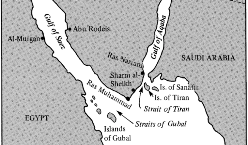
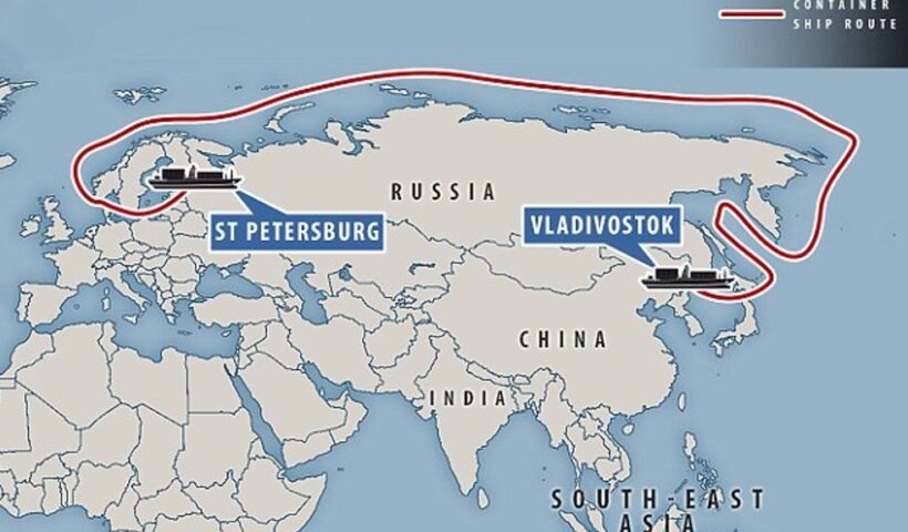
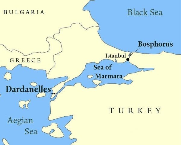
These straits, also known as the Turkish Straits or the Black Sea Straits, connect the Aegean Sea and the Black Sea via the Sea of Marmara. The Bosporus connects the Black Sea with the Sea of Marmara, while the Dardanelles connects the Aegean Sea with the Sea of Marmara. The Bosporus is about 17 miles long and varies in width between one-third and 2 miles. The Dardanelles is about 35 miles long, its width decreases from 4 miles at the Aegean to about 0.7 miles at its narrowest; its depth varies from 160 to 320 feet. The Sea of Marmara is about 140 miles long. Navigational Regimes of Particular Straits, Bosporus and Dardanelles case study, A map showing the Straits, Aegean sea, Black Sea Straits, Bosporus and Dardanelles, How deep is the Bosporus Dardanelles channel?, Montreux Convention, Sea of Marmara, The Dardanelles and Bosporus Passages, Turkish Straits, Who controls Black Sea?, Why are the Bosporus and Dardanelles important?, Why are the Bosporus and Dardanelles straits significant

View More Navigational Regimes of Particular Straits, Bosporus and Dardanelles case study

Navigational Regimes of Particular Straits, Bonifacio case study

Navigational Regimes of Particular Straits, Bonifacio case study, Bonifacio case study, French island of Corsica, Italian island of Sardinia, Messina Strait, navigation in the Strait of Bonifacio, Navigational Regimes of Particular Straits, Particular Straits, Particularly Sensitive Sea Area, ResearchGate The Bonifacio Strait area, transit of the Strait of Bonifacio

View More Navigational Regimes of Particular Straits, Bonifacio case study

Navigational Regimes of Particular Straits, Bab El Mandeb case study

This strategically important strait links the Red Sea and the Suez Canal with the Gulf of Aden and the Arabian Sea (see Map 29). It is about 14.5 miles wide at its narrowest part of the passage. When it signed the Law of the Sea Convention, the Yemen Arab Republic declared that warships and warplanes must obtain the prior agreement of the Yemen Arab Republic before passing through or over its “territorial waters,” including international straits. The United States Government protested as follows:

View More Navigational Regimes of Particular Straits, Bab El Mandeb case study

Navigational Regimes of Particular Straits, Aland case study

When it ratified the LOS Convention in 1996, Finland confirmed its declaration on signature in part that:
It is the understanding of the Government of Finland that the exception from the transit passage regime in straits provided for in article 35(c) of the Convention is applicable to the strait between Finland (the Åland Islands) and Sweden. Since in that strait the passage is regulated in part by a longstanding international convention in force, the present legal regime in that strait will remain unchanged after the entry into force of the Convention. Navigational Regimes of Particular Straits, Aland case study, Aland case study, Finland, Gulf of Bothnia, international straits, legal regime in that strait, Particular Straits

View More Navigational Regimes of Particular Straits, Aland case study

The 1992 OSPAR Convention as a regional Implementation for Protection and Preservation of the Marine Environment

The OSPAR Convention establishes a comprehensive legal framework for the protection of the marine environment of the North-East Atlantic Area from all sources of marine degradation (not only pollution), except fishing, atmospheric and vessel-source pollution, which are considered to be appropriately regulated within other frameworks..The 1992 OSPAR Convention as a regional Implementation for Protection and Preservation of the Marine Environment, e North Sea and other parts of the North-East Atlantic, Oslo Dumping Convention, OSPAR, OSPAR Commission, OSPARCOM, Paris Convention on Land-based Pollution, Protection and Preservation of the Marine Environment, regional Implementation for Protection and Preservation of the Marine Environment, The 1992 OSPAR Convention

View More The 1992 OSPAR Convention as a regional Implementation for Protection and Preservation of the Marine Environment

The 1992 Helsinki Convention as a regional Implementation for Protection and Preservation of the Marine Environment

The 1992 Helsinki Convention as a regional Implementation for Protection and Preservation of the Marine Environment, Baltic Sea, ecological restoration, Helsinki Convention, marine ecosystems, Protection and Preservation of the Marine Environment, regional Implementation for Protection and Preservation of the Marine Environment, The 1992 Helsinki Convention

View More The 1992 Helsinki Convention as a regional Implementation for Protection and Preservation of the Marine Environment

The 1976 Barcelona Convention (BARCON) as a regional Implementation for Protection and Preservation of the Marine Environment

The 1976 Barcelona Convention (BARCON) as a regional Implementation for Protection and Preservation of the Marine Environment, 1976 Barcelona Convention for the Protection of the Mediterranean Sea against Pollution, Barcelona Convention, BARCON, Mediterranean sea, Preservation of the Marine Environment, Protection of the Mediterranean Sea against Pollution, UNCED, UNEP’s Regional Seas Agreements

View More The 1976 Barcelona Convention (BARCON) as a regional Implementation for Protection and Preservation of the Marine Environment

The Regional Implementation Regime for Protection and Preservation of the Marine Environment

The Regional Implementation Regime for Protection and Preservation of the Marine Environment, Agenda 21, BARCON, Bern Convention for the Protection of European Habitats, Euro-Mediterranean Process, HELCOM, How can we protect the marine environment?, LOSC, OSPAR, Preservation of the Marine Environment, What are the obligations to protect and preserve the marine environment?, Who is the responsible about the protection of marine environment?

View More The Regional Implementation Regime for Protection and Preservation of the Marine Environment

“Generally Accepted” and “Applicable” International Rules for Protection and Preservation of the Marine Environment

“Generally Accepted” and “Applicable” International Rules for Protection and Preservation of the Marine Environment, GAIRAS, How can we protect marine life from degradation?, How can we protect our marine environment?, International Maritime Organization, LOSC, Protection and Preservation of the Marine Environment, United Nations Environment Programme (UNEP), What are marine environmental issues?, What are the main divisions of the marine environment?, What are the obligations to protect and preserve the marine environment?, What are three important environmental laws?, What can you contribute in the preservation of marine life?, Who is the responsible about the protection of marine environment?, Why is it important to protect the marine environment?

View More “Generally Accepted” and “Applicable” International Rules for Protection and Preservation of the Marine Environment

World Summit on Sustainable Development (WSSD) and Protection and Preservation of the Marine Environment

World Summit on Sustainable Development (WSSD) and Protection and Preservation of the Marine Environment, Agenda 21, Protection and Preservation of the Marine Environment, What is the main aim of Agenda 21?, What is World Summit on Sustainable Development?, What was discussed at the Johannesburg Earth Summit?, What was the result of the 1992 Earth Summit?, WSSD

View More World Summit on Sustainable Development (WSSD) and Protection and Preservation of the Marine Environment

Chapter 17 of Agenda 21 about the Protection and Preservation of the Marine Environment

Chapter 17 of Agenda 21 about the Protection and Preservation of the Marine Environment, Chapter 17 of Agenda 21, How many agreement are there in Agenda 21?, marine ecosystems, Preservation of the Marine Environment, What are the two principles of Agenda 21?, What is Agenda 21 and its principles?, What is the main aim of Agenda 21?

View More Chapter 17 of Agenda 21 about the Protection and Preservation of the Marine Environment

The 1982 UN Law of the Sea Convention (LOSC) and the Protection and Preservation of the Marine Environment

The environmental regime established by the Convention is based on the combination of the jurisdictional rules of the law of the sea with objectives, principles and approaches of international environmental law. The protection and preservation of the marine environment is specifically regulated in Part XII which is the result of this combination.
However, due to the comprehensive character of the LOSC and the inter-sectoral nature of marine issues, relevant provisions can be found in different parts of the Convention (e.g., Parts V and VII on conservation and management of living resources in the EEZ and high seas or Part XIII on marine scientific research). The LOSC has codified the customary principles discussed in the previous section and, in some cases, has further clarified their content. The jurisdictional rules and Part XII are discussed separately in the next paragraphs. The 1982 UN Law of the Sea Convention (LOSC) and the Protection and Preservation of the Marine Environment, LOSC, Protection and Preservation of the Marine Environment, What do the provision of Unclos 1982 govern?, What does the law of the sea convention do?

View More The 1982 UN Law of the Sea Convention (LOSC) and the Protection and Preservation of the Marine Environment