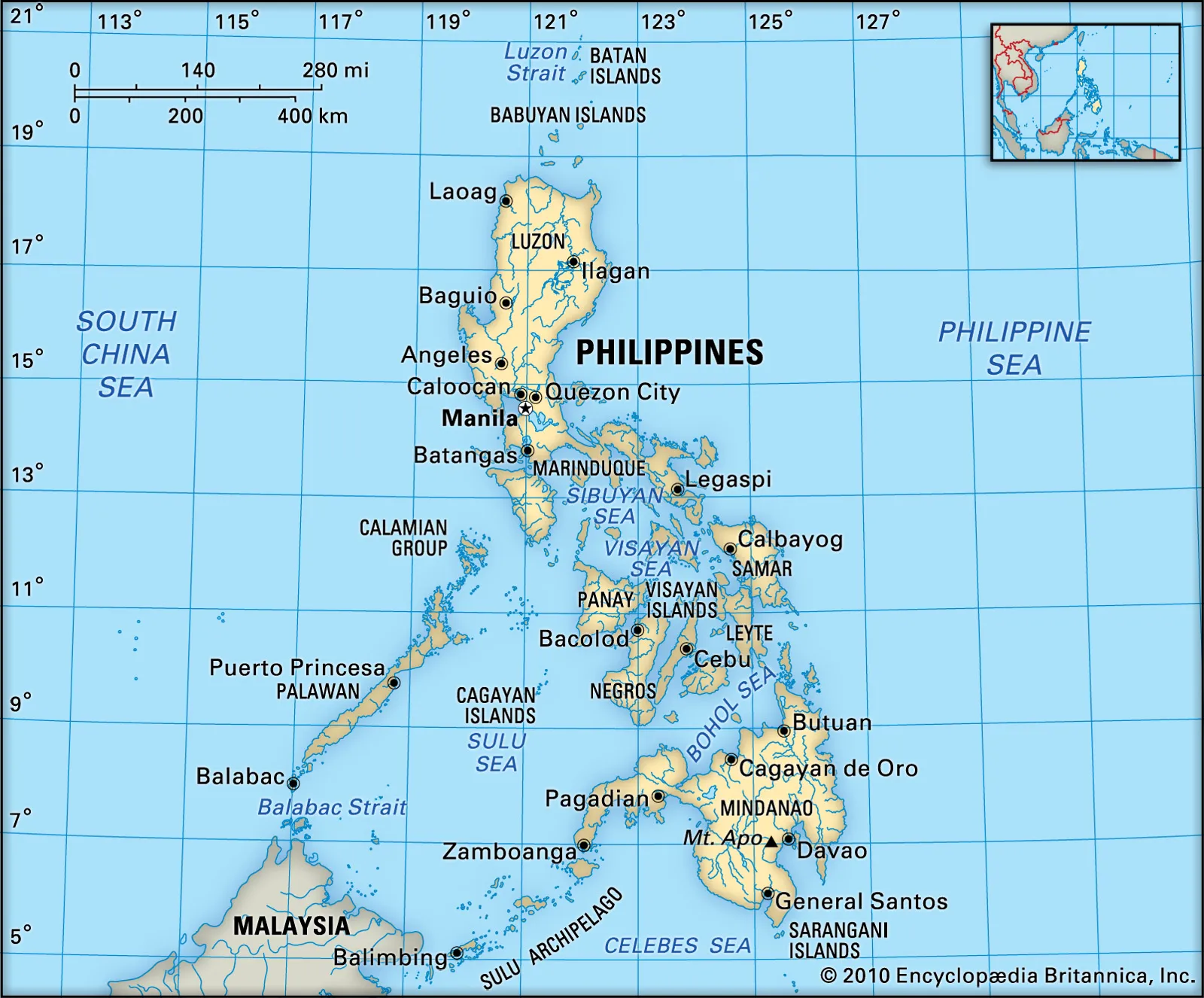
The sea’s surface area is 260,000 square kilometers (100,000 sq mi). The Pacific Ocean flows into Sulu Sea in northern Mindanao and between Sangihe talaud Archipelago, North Sulawesi. Sulu Sea, portion of the western North Pacific Ocean. It is bounded by northeastern Borneo on the southwest, the southwestern islands of the Philippines, including Palawan, on the west and northwest, Busuanga and Mindoro on the north, Panay and Negros on the east, and Mindanao and the Sulu Archipelago on the southeast. Sulu Sea is also where the Tubbataha Reef National Marine Park, one of the World Heritage Sites is located. The Panay Gulf is an extension of the Sulu Sea.
The sea is now extensively used for interisland trade. Fishing is important and marine products include pearls, pearl shells, bêche-de-mer (trepang), shark fins, and turtle eggs. The reefs of the Sulu Sea are world-renowned among sport-diving enthusiasts. The Sulu Sea boasts one of the world’s most productive and diverse ecosystems. Sulu-Sulawesi Seascape is shared by the nations of Indonesia, Malaysia, and the Philippines, who are also responsible for its conservation.
The Sulu and Celebes Seas, a semi- enclosed sea area and porous region that covers an area of space around 1 million square kilometres, have been subject to illegal maritime activities since the pre-colonial era and continue to pose a maritime security threat to bordering nations up to this day.
The International Hydrographic Organization (IHO) defines the Sulu Sea as being one of the waters of the East Indian Archipelago. The IHO defines its limits as follows:
It extends about 490 miles (790 km) from north to south and 375 miles (604 km) from east to west. Waves can stretch across 25 kilometers (16 mi) to 35 kilometers (22 mi). The sea is 4,400 meters (14,400 ft) deep but on its southern end Sulu Archipelago raises the sea floor to 100 meters (330 ft).
On the Northwest. From Tanjong Sempang Mangayau, the North point of Borneo, along the Eastern limit of South China Sea to Cape Calavite, the Northwest point of Mindoro.
On the Northeast. The Southwest coast of Mindoro to Buruncan Point, its Southern extreme, thence a line through Semirara and Caluya Islands to Nasog Point (11°53′N 121°53′E) the Northwestern extreme of Panay, along the West and Southeast coast of that island to Tagubanhan Island (11°08′N 123°07′E), thence a line to the Northern extreme of Negros and down the West coast to Siaton Point, its Southern extreme, thence across to Tagolo Point (8°44′N 123°22′E), Mindanao.
On the Southeast. From Tagolo Point, down the West coast of Mindanao to the Southwest extremity thence to the North coast of Basilan Island (6°45′N 122°04′E), through this island to its Southern extremity, thence a line to Bitinan Island (6°04′N 121°27′E) off the Eastern end of Jolo Island, through Jolo to a point in long. 121°04’E on its South coast, thence through Tapul and Lugus Islands and along the North coast of Tawi Tawi Island to Bongao Island off its Western end (5°01′N 119°45′E), and from thence to Tanjong Labian, the Northeastern extreme of Borneo.
On the Southwest. The North coast of Borneo between Tanjong Labian and Tanjong Sempang Mangayau.
The Sulu Sea (Filipino: Dagat Sulu; Tausug: Dagat sin Sūg; Chavacano: Mar de Sulu; Cebuano: Dagat sa Sulu; Hiligaynon: Dagat sang Sulu; Karay-a: Dagat kang Sulu; Cuyonon: Dagat i’ang Sulu; Malay: Laut Sulu) is a body of water in the southwestern area of the Philippines, separated from the South China Sea in the northwest by Palawan and from the Celebes Sea in the southeast by the Sulu Archipelago. Borneo is found to the southwest and Visayas to the northeast.
The Sulu Sea contains a number of islands. The Cuyo Islands and the Cagayan Islands are part of the province of Palawan whereas Mapun and the Turtle Islands are part of the province of Tawi-Tawi. Sulu Sea is also where the Tubbataha Reef National Marine Park, one of the World Heritage Sites is located.
The Panay Gulf is an extension of the Sulu Sea. Straits out of the Sulu Sea include the Iloilo Strait, the Guimaras Strait, and the Basilan Strait.
Are there sharks in Sulu Sea? A world-class marine protected area
As a result, it has become a haven for sharks. Clouds of juvenile grey reef sharks shimmer on the reefs, while white tip reef sharks cruise by with giant trevally, looking for their next unsuspecting meal. Tiger sharks, the crown jewel of the park, are more elusive.
What religion is Sulu? Muslim
The Sulu people are a Muslim community living in the Sulu Archipelago, a chain of islands in the Pacific Ocean in the south-western Philippines with around 700 thousand inhabitants.
Is there oil in Sulu Sea?
Sulu sea has strategic mineral deposit and rich with oil and gas. Your natural gas will propel great economic development not only in this island but for the whole Philippines.”
Does Philippines recognize Sulu?
In 1962, the Philippine government under the administration of President Diosdado Macapagal officially recognised the continued existence of the Sultanate of Sulu.
Is Sulu still part of the Philippines?
Sulu ([sʊˈlu]), officially the Province of Sulu (Tausūg: Wilāya sin Lupa’ Sūg; Tagalog: Lalawigan ng Sulu), is a province of the Philippines in the Sulu Archipelago and part of the Bangsamoro Autonomous Region in Muslim Mindanao (BARMM).
What language do they speak in Sulu?
Tausug (Bahasa Sūg), is the main language of the Sulu Archipelago off Mindanao in the Philippines and in the eastern area of the state of Sabah, Malaysia by the Tausūg people. It is one of the Visayan languages, with the closest related languages being Surigaonon spoken in Surigao provinces.
Who owns Sabah?
The Philippines maintains its territorial claim over Sabah based on the 1878 “Lease Treaty” and based on the historical account that Sabah is a gift from the Sultan of Brunei to the Sultan of Sulu, which is now a region and part of the sovereign territory of the Philippines.
How deep is Sulu Sea? 4400 meters
The Sulu Sea has an average depth of over 4400 meters. It is surrounded by a shallow water regime along the edges of the adjacent landmasses and islands.
Is Sulu prone to tsunamis?
The high vulnerability of Sulu and Tawi–tawi to tsunamis is attributed to the following factors: (i) their location between two nearby trenches (Sulu Trench and Cotabato Trench), and (ii) their high population densities.
Are the sea gypsies or nomads of the Sulu Sea?
The Badjao / Bajau tribe is an indigenous population whose culture and livelihood are tied to the sea. Also widely known as the “Sea Gypsies” of the Sulu and Celebes Seas, the Badjao are scattered along the coastal areas of Tawi Tawi, Sulu, Basilan, and some coastal areas of Zamboanga City.
Why Raiders of the Sulu Sea is important?
Throughout the three and half centuries of conflicts between the Spanish and the populations of the southern Philippines, maritime raiding played a key role, not only for the accumulation of wealth and slaves, but also as a means of warfare and anticolonial resistance.
Who is the Princess of Sulu?
Princess Tarhata Kiram was a Moro leader. She was the niece and adopted daughter of Jaramul Kiram II, Sultan of Sulu.
Does Sulu have a husband?
Film’s co-writer Doug Jung to play Sulu’s husband
Much has been made of the decision to reveal that the Star Trek character Sulu is gay in the latest franchise installment Star Trek Beyond, but for actor John Cho, one of the most important things was ensuring that Sulu’s husband was also of Asian descent.
Is the Philippines rich in oil?
The Philippines has only two active petroleum fields: Galoc, an offshore field in the Northwest Palawan Basin, and Alegria, an onshore field in the Province of Cebu.
What is the main product of Sulu?
Agricultural products include coconut, cassava, abaca, coffee, lanzones, jackfruit, durian, mangosteen and marang. Jolo is the only municipality in Sulu that does not farm seaweed.
Who introduced Islam in Sulu? Makhdum Karim
In 1380, Makhdum Karim reached the Sulu Archipelago and Jolo in the Philippines and established Islam in the country through trade in several regions of the island. In 1390, Minangkabau Prince Rajah Baguinda and his followers preached Islam on the islands.