Article 47(1) of the LOSC provides as follows :
An archipelagic State may draw straight archipelagic baselines joining the outermost points of the outermost islands and drying reefs of the archipelago.
A key point is that the legal criteria of being an archipelago must be fulfilled in order to construct archipelagic baselines. In other words, a State which does not meet the legal definition of an archipelagic State is not entitled to draw archipelagic baselines. The language of this provision also suggests that the establishment of archipelagic baselines is facultative. Article 47 sets out conditions for drawing these baselines in some detail.
(i) The archipelagic waters must include main islands, and the ratio of the area of the water to the area of the land, including atolls, is between 1 to 1 and 9 to 1 pursuant to Article 47(1). The lower ratio was designed to exclude those archipelagos which are dominated by one or two large islands or islands that are connected only by comparatively small sea areas. This requirement will not allow, for instance, Australia, Cuba, Iceland, Madagascar, New Zealand and the United Kingdom to draw archipelagic baselines. The upper ratio was intended to exclude those archipelagos which are widely dispersed, such as Tuvalu and Kiribati. Article 47(1) does not provide any further precision with regard to the meaning of ‘main islands’. Thus the meaning could be interpreted in various ways.
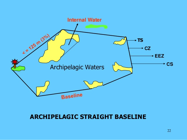
(ii) The length of such baselines shall not exceed 100 nautical miles. But up to 3 per cent of the total number of baselines enclosing any archipelago may exceed that length, up to a maximum length of 125 nautical miles pursuant to Article 47(2). It is notable that unlike straight baselines, the maximum length of the archipelagic baselines is fixed. Considering that there is no restriction on the number of baseline segments that can be used in order to draw archipelagic baselines, however, it appears possible for the archipelagic State to adjust the number of segments in order to secure the necessary number of very long baselines.
(iii) The drawing of such baselines shall not depart to any appreciable extent from the general configuration of the archipelago under Article 47(3). This elusive criterion seeks to ensure a linkage between the unit or entity concept and the technique for drawing archipelagic baselines.
(iv) Archipelagic baselines shall not be drawn to and from low-tide elevations, unless lighthouses or similar installations which are permanently above sea level have been built on them or where a low-tide elevation is situated wholly or partly at a distance not exceeding the breadth of the territorial sea from the nearest island in accordance with Article 47(4). On the other hand, as quoted earlier, Article 47(1) provides that ‘an archipelagic State may draw straight archipelagic baselines joining the outermost points of the outermost island and drying reefs’. At UNCLOS III, it was understood that ‘drying reefs’ were above water at low tide but submerged at high tide. It would follow that ‘drying reefs’ are low-tide elevations. If this is the case, paragraph 1 of Article 47 may seem to contradict paragraph 4 of the same provision which prohibits drawing archipelagic baselines to and from low-tide elevations. In response to this question, a possible interpretation may be to apply the condition set up in Article 47(4), ‘unless lighthouses or similar installations’, to Article 47(1). According to this interpretation, an archipelagic State may draw straight archipelagic baselines joining the outermost points of the outermost drying reefs, provided that ‘lighthouses or similar installations which are permanently above sea level have been built on them or where drying reefs are situated wholly or partly at a distance not exceeding the breadth of the territorial sea from the nearest island’.
(v) The system of archipelagic baselines shall not be applied by an archipelagic State in such a manner as to cut off from the high seas or the EEZ the territorial sea of another State under Article 47(5).
(vi) Archipelagic baselines shall be shown on charts of a scale or scales adequate for ascertaining their position. Alternatively, lists of geographical coordinates of points, specifying the geodetic datum, may be substituted. Furthermore, the archipelagic State shall give due publicity to such charts or list of geographical coordinates and shall deposit a copy of each such chart or list with the UN Secretary-General in accordance with Article 47(9).
In some instances, States that are not archipelagic States but that have offshore islands forming an archipelago claim straight baselines around the outermost perimeter of those islands. However, there appears to be good reason to argue that such baselines are at variance with Articles 5, 7, 46 and 47 of the LOSC. In fact, the ICJ, in the Qatar/Bahrain case, made clear that: ‘[T]he method of straight baselines is applicable only if the State has declared itself to be an archipelagic State under Part IV of the 1982 Convention on the Law of the Sea.’ This view was echoed by the Annex VII Arbitral Tribunal in the South China Sea arbitration (Merits), which stated:
[T]he grant of permission in Article 7 concerning straight baselines generally, together with the conditional permission in Articles 46 and 47 for certain States to draw archipelagic baselines, excludes the possibility of employing straight baselines in other circumstances, in particular with respect to offshore archipelagos not meeting the criteria for archipelagic baselines. Any other interpretation would effectively render the conditions in Articles 7 and 47 meaningless.
In practice, claims to enclose offshore archipelagos have been protested by multiple States. Furthermore, many States which have offshore archipelagos have not sought to enclose them with straight baselines. Consequently, it appears that the practice of States drawing straight baselines around offshore archipelagos is not consistent or widespread.
Nor is there evidence of opinio juris in this matter. Accordingly, it is difficult to consider that a new customary rule permitting States which are not archipelagic States to wholly enclose offshore archipelagos with straight baselines has already been established in positive international law.