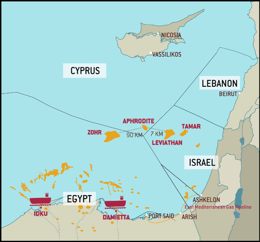
a chart and lists of geographical coordinates of points defining the Western, Northern and Southern limits of Lebanon’s exclusive economic zone, accompanied by Decree No. 6433 – Delineation of the boundaries of the exclusive economic zone of Lebanon, 1 October 2011.

LEBANON’S MARITIME ZONES IN ACCORDANCE WITH UNCLOS
The Zones that Compose a State’s Maritime Space
The 1982 UN Convention on the Law of the Sea (UNCLOS)
adopted in Montego Bay (Jamaica) on 10 December
1982 and which entered into force on 16 November 1994
was acceded to by Lebanon by virtue of Law No. 295 of
22 February 1994. UNCLOS therefore provides the relevant
general framework. While neither Israel nor Syria have
signed or ratified UNCLOS, its provisions on the Continental
Shelf (CS) and Exclusive Economic Zone (EEZ) are by now accepted
as customary international law. Starting from the territorial
sea, different maritime zones each with their separate
legal regime compose a state’s maritime space. Beyond these
maritime areas lie the high seas which are characterized by
freedom of certain activities, such as navigation, the laying of
pipelines and cables and fisheries (UNCLOS Part VII). Law no.
163 on the Delineation and Declaration of the Maritime Zones
of the Lebanese Republic adopted on 17 August 2011 follow
the zones delineated by UNCLOS.
– The Baselines
The baseline is the line from which the breadth of the territorial
waters is measured. Lebanon has relied on the
normal baseline for measuring the breadth of the territorial
sea which is the low-water line along the coast as
marked on official large-scale charts, as well as “straight
lines that connect suitable baselines in accordance with
the regulations of the International Law, starting from the
center of the mouth of the Nahr Al-Kabir Al-Shamali, (or
Northern Great River) to the beginning of the 1949 ceasefire
line to the South.” (Law no.163, Article 2).
While the International Court of Justice has stated that the
method of straight baselines joining appropriate points on land
may be employed only in exceptional circumstances, e.g. where
the coast is highly indented or has fringes of islands, as in Norway,
a large number of coastal states, including Cyprus have
established straight baselines systems along coastlines which
are far from corresponding to the Norwegian model.
“ The waters on the landward side of the Lebanese Baseline
form an integral part of the Internal Waters of the Lebanese
Republic” (Law, Article 3). ”
– The Territorial Sea
Lebanon has established a 12 nautical mile (NM) territorial
sea – an adjacent belt of water which extends beyond
its land territory and internal waters the outer limit
of which “is the line every point of which is at a distance
from the nearest point of the Baseline equal to the
breadth of the Territorial Sea” (Law, Article 4). Lebanese
sovereignty extending over this belt of sea is identical to
that which it exercises over its land territory, i.e. it extends
also to the airspace above the territorial sea and
to the seabed below it, with the exception of a right of
“innocent passage” for foreign vessels (Law, Article 12)
(see UNCLOS Part II).
– The Contiguous Zone
Lebanon also has the right to exercise control over a zone contiguous
to its territorial sea extending not more than 24 NM
from the baseline (Law, Article 5(1) ), over which it can exercise
its competence in order to (Article 5(2)):
“a- Prevent infringement of Lebanese rules and regulations
relative to security, customs, sanitary, fiscal, immigration
laws and pollution both within their land territory
or Territorial Sea
b- Enforce punishment on the infringement of the
aforementioned rules and regulations whether this infringement
occurs within their land territory or Territorial
Sea.”
– The Continental Shelf (CS)
Since the Continental Shelf is a legal not just a geographical
concept, Lebanon which has only a narrow continental
shelf nevertheless possesses a continental shelf comprising
the seabed and subsoil of the submarine areas
that extend beyond its territorial sea to a distance which
does not exceed 200 NM from its baselines (Law, Article 8).
Lebanon exercises sovereign rights over this area for the
purpose of exploring and exploiting its natural resources
(mineral and non-living resources together with sedentary
living organisms) on the seabed and subsoil, including
by drilling. In addition, Lebanon has the exclusive right to
construct artificial islands, installations and structures for inter
alia economic purposes (Article 11).
No other state may exercise the same rights without its
express consent. All States are however entitled to lay submarine
cables and pipelines on the CS, but the Lebanese Republic
establishes the conditions and controls pollution (Law,
Article 10).
The CS does not require any occupation or any express
proclamation (UNCLOS Part VI, Law, Article 9 ).
– The Exclusive Economic Zone (EEZ)
The Exclusive Economic Zone, which Lebanon has declared,
is according to UNCLOS, an area beyond and adjacent
to the territorial sea which must not exceed 200
NM from the coastal baseline (UNCLOS Part V). Article 6
of Law no. 163 states:
“The Exclusive Economic Zone (EEZ) of the Lebanese Republic
is determined from the Baseline and stretches to a distance
of 200 NM maximum, in accordance with the provisions of the
United Nations Convention on the Law of the Sea and other
relevant regulations of international law. It extends westward
in the sea to reach at least:
a- (to the North-West) the equidistant point to the nearest
Lebanese, Syrian and Cypriot coastline
b- (to the South-West) the equidistant point to the nearest
Lebanese, Cypriot, and occupied Palestinian coastline.”
In its EEZ, the coastal State enjoys sovereign rights for the
purpose of exploring and exploiting, conserving and managing
the natural resources both living and non-living not
only on the seabed and subsoil but also in the superjacent
waters and with regard to other activities for the economic exploitation
and exploration of the zone, such as the production
of energy from the water, currents and winds. This is reflected
in Article 7 of the Lebanese Law.
As with the CS, Lebanon has jurisdiction with regard to the
construction of artificial islands and installations and structures
and for the carrying out of marine scientific research. At
the same time, Lebanon has certain duties over the area,
e.g. to protect and preserve the marine environment and
to prevent pollution in the area. However, the EEZ remains
free to all States for purposes of navigation, overflight and laying
cables and pipelines, provided that they do not threaten the
security of the coastal State.
Article 7 (3) further provides that Lebanon has:
“other rights and duties provided for by the United Nations
Convention on the Law of the Sea and other international
treaties, conventions, and laws.
These rights, duties and jurisdictions are exercised in accordance
with the provisions of this law and its executive
texts.
In exercising its rights and performing its duties in the EEZ,
the Lebanese Republic shall have due regard to the rights
and duties of third party states.
The rights set out in this article with respect to the seabed
and subsoil shall be exercised in accordance with the article
relative to the Continental Shelf.”
Other types of zones have been declared by some Mediterranean
States such as “fishery zones” and “ecological protection
zones”. Lebanon, which is party to the UNESCO Convention for
the Protection of the Underwater Cultural Heritage, could for instance
establish a contiguous zone for archaeological and cultural
purposes (see Law, Article 14).
LEBANON’S EXCLUSIVE ECONOMIC ZONE AND ITS DELIMITATION
The Importance of an EEZ for Lebanon
As stated above, since the CS which, unlike the EEZ, belongs
to Lebanon as of right and cannot be claimed by
any State to the extent that it does not overlap with another
State’s continental shelf, Lebanon could have undertaken
exploration and exploitation of gas and oil reserves
immediately. The EEZ on the other hand requires
an express proclamation and clearly expressed intention
in its domestic laws.
However, in view of the fact that Lebanon’s neighbours Cyprus
and Israel have proclaimed their EEZ which has subsumed
their continental shelf, Lebanon would have anyway
had to face delimitation of its CS and EEZ. Moreover,
the team of experts pointed out that an EEZ adds the possibility
of exploitation of the natural resources of the overlying
waters, such as fishery resources, and gives Lebanon
the right to extend its laws to this area for purposes
of conservation of marine resources and control of pollution
of the waters in the zone. It was stressed that the
EEZ is now part of customary law, therefore opposable
even to States not parties to UNCLOS. Moreover, establishing
– and regulating – an EEZ is fundamental to guarantee
the security of the installations used to exploit gas
and oil resources. In view of the political instability of the area, it would have been risky for Lebanon to have begun
its exploration activities without first declaring an EEZ.
Lebanon’s proclamation of an EEZ incorporated in its Law
No. 163 and consolidated by Government Decree No. 6433
dated 1 October 2011, was therefore timely. Of its immediate
neighbours, Syria (in 20037) and Cyprus (in 2004)8 had already
proclaimed their EEZ as a zone beyond and adjacent to
the territorial sea, the outer limit of which shall not extend beyond
the 200 NM from the baselines from which the breadth of
the territorial sea is measured (as UNCLOS provides). Though
Israel like Syria is not a party to UNCLOS, it proclaimed its own
EEZ in 20119. Syria and Israel presumably base their right to
an EEZ on customary international law.
It is important that Lebanon accompanies such a declaration
of an EEZ by a network of legislative and regulatory
measures.
The Geographical Coordinates Deposited by Lebanon with the UN Secretary-General
In accordance with the requirements of UNCLOS, Lebanon had,
by notes of 14 July 2010 and 11 October 2010 deposited with
the Secretary-General of the United Nations the charts and lists
of geographical coordinates for the delimitation of the EEZ, respectively,
the southern, south-western and northern maritime
borders. These had been adopted by the Council of Ministers
in its Decision no. 51 of 21 May 2009. Lebanon’s note concludes
with the following comment:
“There is a need to conduct a detailed survey, using a
global positioning system, of the shore contiguous to
the southern limit, including all islands and spurs, with a view to updating the nautical charts and the baseline
accordingly in the future”.
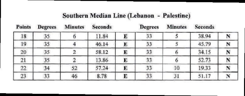
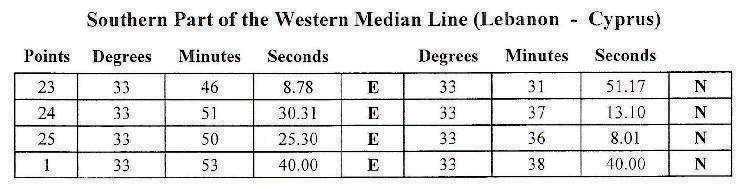
Lebanon declared that the southern maritime border extends
from point B1 on the shore at Ra’s Naqurah, the
first point on the 1949 Israeli-Lebanese General Armistice
Agreement table of coordinates, to point 23, that is equidistant
between the three countries concerned.