Maritime borders in the Baltic Sea were delineated between Denmark and Poland in 2018, but not into force till now. The northern shores of the Baltic Sea are characterised by highly indented coastlines together with a multitude of islands and rocks. The presence of these features has complicated delimitation negotiations over the years. Nevertheless, the Baltic’s littoral states have been largely successful in overcoming the difficulties presented by the presence of islands. For example, Sweden and the USSR were able to overcome their differences over the role of Sweden’s Gotland by innovatively according the island a 75% effect. Similarly, Finland and Sweden were able to resolve their differences over the impact of the small islets and rocks belonging to Finland’s near the mouth of the Gulf of Bothnia in the Bogskär area in 1995.
However, the maritime boundary between the Danish island of Bornholm and Poland to the south has yet to be delimited. Bornholm lies around 72 nm east of the Danish mainland and, as a consequence of the configuration of coasts at the mouth of the Kattegat, forms a 2,700 nm2 pocket of Danish claimed maritime space surrounded by the claims of Germany, Poland and Sweden. The western end of a Denmark-Poland equidistance line between Bornholm and the Polish mainland intersects with the final segment of the German Democratic Republic-Poland boundary of 1968. Article 2 of the 1968 agreement defines an equidistant maritime boundary extending from the terminal point of the land frontier on the coast, through through Points A to H, ‘and an extension of the line between Points G and H to a point equidistant from the nearest points of the baselines of the Polish People’s Republic, the German Democratic Republic and the Kingdom of Denmark’. collogues has interpreted this as meaning that the azimuth applied to the line G-H should also be applied to link Point H to the tripoint. On this basis, the Denmark-Germany-Poland tripoint is located at approximately
54° 02’ 15” N, 14° 38’ 30” E.
An equidistance-based maritime boundary between Denmark (Bornholm) and Poland would extend generally eastwards then northeast for approximately 70 nm to a Denmark-Poland-Sweden tripoint in the vicinity of the western terminus
of the Poland-Sweden continental shelf and fishing zones boundary of 1989. Article 2 of the 1989 treaty defines the western end of the boundary, Point A, as being located at 55° 21,640’ N, 16° 32,000’ E. West of Point A it is stated that the boundary ‘shall extend as far as the points on which agreement is reached with any third State concerned’. Thus, the western tripoint with Germany appears to be somewhat better defined than that with Sweden, though neither should present the parties with particular difficulties as equidistance is accepted as the basis for the Denmark (Bornholm)-Poland delimitation.
There seems little reason to argue for a departure from equidistance in this case. Not only has equidistance proved to be the favoured method of delimitation for the overwhelming majority of maritime boundaries of the Baltic, but Bornholm has already been accorded full effect in other maritime boundary delimitation agreements. For example, Sweden gave full weight to Bornholm in the construction of a simplified equidistance line in its delimitation agreement with Denmark of 1984. However, it should be noted in connection with this delimitation that political and strategic delimitation considerations were important. in concluding a delimitation giving full weight to Bornholm, Denmark and Sweden apparently felt that this ‘would strengthen the Danish position vis-à-vis the GDR [German Democratic Republic] and Poland and the Swedish position in support of full effect for Gotland vis-à-vis Poland and the USSR’. Nevertheless, Bornholm is a relatively large (588 km2) island with a population of around 44,000, and is thus no inconsequential islet that could be readily discounted
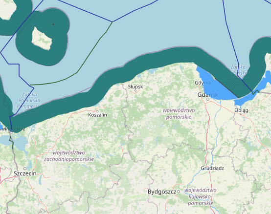


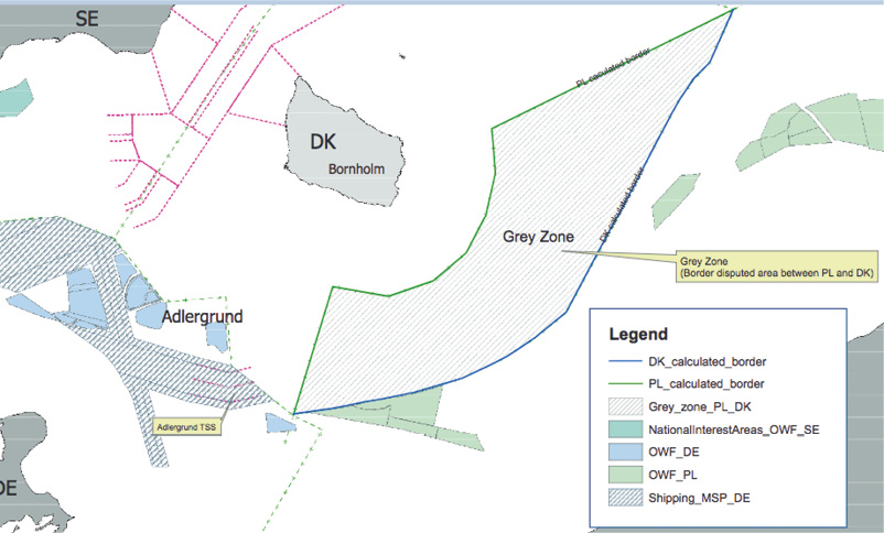
The “Grey Zone” is a disputed area in the EEZ of Denmark and Poland, which is an issue that goes beyond the planning mandates of the two countries, but has clear implications for their work (Figure 29). While a resolution for this disputed area cannot be solved between planning authorities, the planners of the two countries were successful in engaging their Ministries of Foreign Affairs into a bilateral dialogue. This interaction eventually led to the identification of a temporary solution, which made it possible for planners to proceed with their MSP processes, while the border conflict is solved at a higher political level. Although sceptical at the beginning, planners were highly satisfied with the pragmatic result of this dialogue. This is an approach to collaboration, which is also applicable to other grey zones, such as the harbour approach of the Świnoujście-Szczecin area between Germany and Poland, and other similar cases within and outside the Baltic Sea.