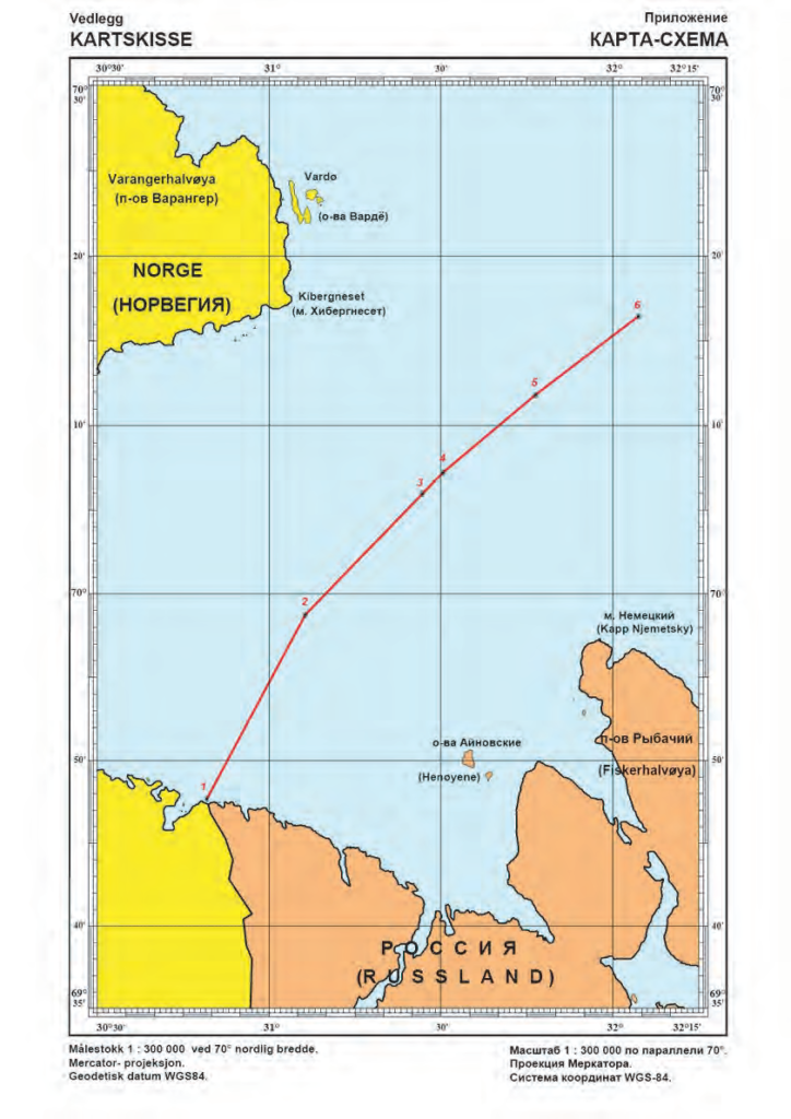
Norway and Russia have delimited their maritime jurisdiction in the maritime areas north of their land boundary. Norway and the former Soviet Union concluded a maritime boundary agreement in 1957 delimiting the territorial sea and continental shelf within Varangerfjorden, a fjord lying seaward of the Norway-Soviet land boundary. The 1957 agreement was superseded by a 2007 agreement between Norway and Russia that delimited the territorial sea, continental shelf, and EEZ in the Varangerfjorden area. This boundary extends from the terminus of the land boundary to an area just seaward of the mouth of Varangerfjorden and is composed of geodetic lines connecting six points, with a total length of approximately 39 M. The agreement contains provisions pertaining to the existence of possible hydrocarbon deposits extending across the boundary line.
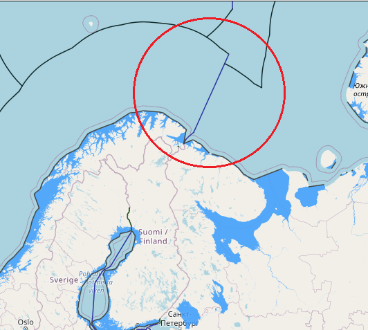
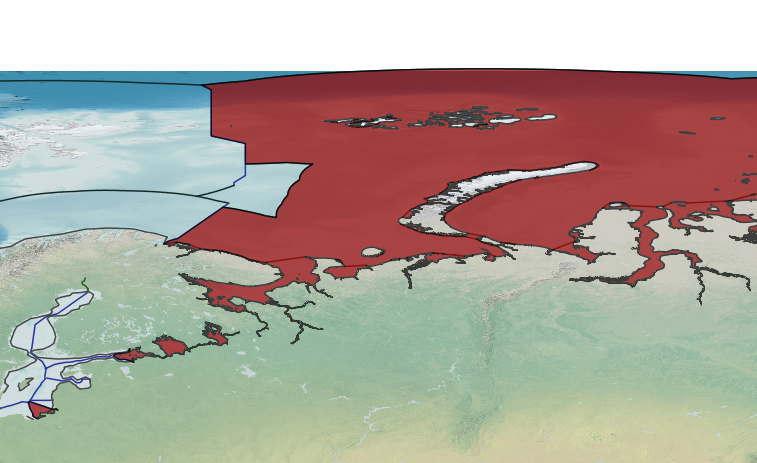
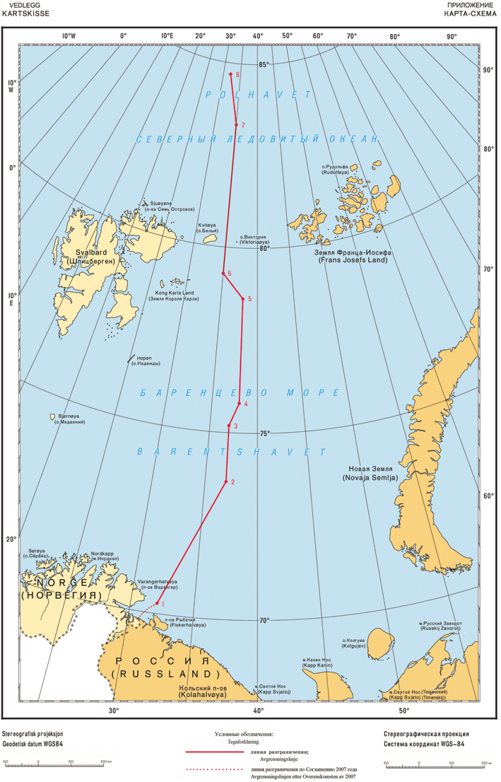
Norway and Russia concluded a maritime boundary agreement in 2010 delimiting the EEZ and continental shelf of the two countries in the Barents Sea and Arctic Ocean. The boundary is composed of geodetic lines connecting eight points, with a total length of approximately 907 M. The boundary begins at the terminus of the Varangerfjorden boundary (in the south) agreed in 2007 and terminates in the Arctic Ocean at the point where the last boundary segment (between boundary points 7 and 8) intersects with a line connecting the continental shelf limits of both countries “as established in accordance with Article 76 and Annex II of the Convention.” The 2010 boundary separates the maritime zones generated by the mainland coasts of both countries and also by Svalbard (to the west) and Russia’s Franz Josef Land and Novaya Zemlya (to the east).
The boundary delimits continental shelf beyond 200 M in two areas: (1) near its northern extent (Arctic Ocean) and (2) in the south-central area (“loop hole” in the Barents Sea). The agreement includes annexes addressing matters relating to fisheries and transboundary hydrocarbon deposits.

Negotiations on the outside marine border were initiated in 1970. Norway claimed, in accordance with the United Nations Convention on the Law of the Sea Article 15 and the Convention on the High Seas, that the border should follow the equidistance principle, the border being defined by midpoints between the nearest land area or islands, as is normal practice internationally. The Soviet Union claimed, based on a decision by Joseph Stalin from 1926, which was not recognized by any other country than the Soviet Union, that a “sector principle” should apply, such that the border should follow meridian lines. Most of the disputed area was within what would normally be considered Norwegian according to the relevant international treaties. In 1975 the two countries agreed upon a moratorium prohibiting exploration for oil and gas in the disputed area.
In 1978 a temporary agreement regulating fishery in a 60,000 km2 (23,000 sq mi) zone, named The Grey Zone in some documents from the same period, was signed, which has since been renewed annually. From the Norwegian side, the agreement was negotiated by Labour Party politician Jens Evensen and his protégé Arne Treholt, who was later exposed as a Soviet spy and convicted of high treason. The agreement was highly controversial in Norway. Many Norwegians believed that Evensen and Treholt gave too many concessions to the Soviet Union, and that they were motivated by Soviet sympathies. The agreement caused consternation in parliament and government, and Evensen had difficulty receiving acceptance from his own government, where many held the opinion that he had exceeded his authority. The opposition criticized him for having accepted less than Norway’s rightful claim. Treholt, who was then serving a twenty-year sentence, admitted in 1990 that he had acted as an informer for the Soviet negotiators. The arrest and conviction of Treholt in 1984 and 1985 had a devastating effect on Evensen, who withdrew completely from public life in Norway. In 1989, Evensen compared Treholt to Vidkun Quisling.
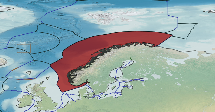
During a meeting in Oslo on 27 April 2010, President of Russia Dmitry Medvedev and Prime Minister of Norway Jens Stoltenberg announced that the territorial dispute in the Barents Sea was settled. The agreement is a compromise which divides a disputed area of around 175,000 square kilometers (68,000 sq mi) into two approximately equally sized parts. The agreement was signed on 15 September 2010 in Murmansk by Medvedev and Stoltenberg. The Parliament of Norway unanimously approved the treaty on 8 February 2011. The debate lasted only an hour, and all representatives of Norwegian political parties praised the agreement. On 30 March, Russia’s State Duma also voted in support of ratification, despite strong opposition from Communist Party representatives. Medvedev signed a law ratifying the treaty on 8 April 2011. The law was titled Federal Law on Ratification of the Treaty between the Russian Federation and the Kingdom of Norway on Maritime Delimitation and Cooperation in the Barents Sea and the Arctic Ocean. After ratification by both countries, there was a 30-day waiting period before it would come into force.
The treaty entered force on 7 July 2011, ending the 44-year-old border dispute. The treaty stipulates conditions for fishing cooperation, providing for the retention of the mechanism to jointly regulate fishing in the Barents Sea. The treaty also defines the principles of cooperation in hydrocarbons deposits exploration. A deposit which is crossed by the maritime border may only be exploited as a whole subject to a bilateral agreement. The border treaty is economically significant, as it makes possible to conduct geological surveys and hydrocarbons drilling in the formerly disputed area, which is estimated to contain up to 6.8 billion tons of oil and gas. The area is located west of Shtokman, one of the world’s largest natural gas fields. According to Anatoly Zolotukhin, vice president of World Petroleum Council, it is “a very prolific area—maybe even more prolific than Shtokman.” The Norwegian company Petroleum Geo-Services has been contracted to begin surveying the Norwegian part of the area in 2011. Seismic acquisition in Norway’s new maritime zone started on 8 July 2011, and is scheduled to be completed in summer 2012.


