pursuant to article 76, paragraph 9, of the Convention, of a chart and relevant information, including geodetic data, permanently describing the outer limits of its continental shelf
A PARTIAL SUBMISSION OF DATA AND INFORMATION ON THE OUTER LIMITS OF THE CONTINENTAL SHELF OF THE REPUBLIC OF THE PHILIPPINES PURSUANT TO ARTICLE 76 (8) OF THE UNITED NATIONS CONVENTION ON THE LAW OF THE SEA PART

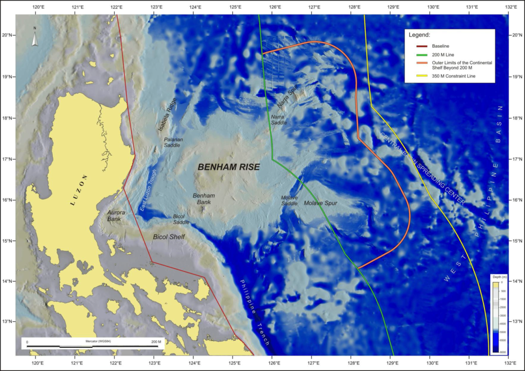
THE OUTER LIMITS OF THE CONTINENTAL SHELF IN THE BENHAM RISE REGION
The Test of Appurtenance
A series of multi-beam bathymetric surveys were conducted by the National Mapping and Resource Information Authority (NAMRIA) in order to determine the morphology of the seabed in the Benham Rise Region. The hydrographic data collected, composed of bathymetric measurements from multi-beam echo-sounding survey cruises conducted between 2004 and 2008, were supplemented by additional data from international bathymetric surveys. In addition to the bathymetric measurements and geomorphological analyses, geological and geophysical data from Philippine and international research projects were compiled and analyzed. These include seismic, magnetic, gravity, and other geological data, as well as the latest published academic literature in geology and geophysics. The information were collected to determine the nature and structure of the seabed and subsoil in the Benham Rise Region and their relationship to the land territory of the Philippines. Analysis of all the data and information collected clearly demonstrated a natural prolongation and geomorphological continuity between the Philippine Island of Luzon and Benham Rise, the structure of which extends beyond 200 M from the baselines of the territorial sea.
The Foot of the Continental Slope plus 60 M Formula
Multi-beam swath bathymetric measurements were used to identify the foot of the continental slope as stipulated in paragraph 4(b) of Article 76, by the points of maximum change in gradient of the seabed in the region where the base of Benham Rise and its associated structures meet the deep ocean floor of the Pacific Ocean. The outer edge of the continental margin in the Benham Rise Region is then determined solely by application of Paragraph 4(a)(i) of Article 76, by reference to fixed points not more than 60 M from the foot of the continental slope.
The 1% Sediment Thickness Formula
The formula in paragraph 4(a)(ii) of Article 76, referring to the percentage of sediment thickness in comparison with the shortest distance to the foot of the continental slope, was not used. Information on sediment thickness at the relevant locations in the Benham Rise Region is not available from marine geophysical surveys to date.
The 350 M Constraint Line
Geodetic information was collected to calculate the location of the constraint line located 350 M from the baselines from which the breadth of the territorial sea is measured, in accordance with paragraphs 5 and 6 of Article 76. This constraint is satisfied since the outer limits of the continental shelf are located landward of the constraint line.
The 2,500 m plus 100 M Constraint Line
Multi-beam bathymetric measurements were used to determine the location of the 2,500 metre isobath in the areas of the Benham Rise Region beyond 200 M from the baselines from which the breadth of the territorial sea is measured. Geodetic methods were used to determine the location of the constraint line located 100 M from the location of the isobath, as described in paragraph 5 of Article 76. However, this constraint line was not applied since the outer edge of the continental margin lies well inside the 350 M constraint line.
The Outer Limits of the Continental Shelf
The outer limits of the continental shelf beyond 200 M in the Benham Rise Region is delineated by straight lines not more than 60 M in length, connecting fixed points not more than 60 M from the foot of the continental slope. The outer limits are illustrated by the orange line in Figure 4. In accordance with paragraph 7 of Article 76, Table 1 lists the coordinates of latitude and longitude (in WGS84) of the turning points of the outer limits, and the distances of the straight lines connecting them.