Traditionally, we’ve learned that continents are enormous landmasses with clearly defined boundaries and separated by oceans.
According to a 2017 paper published in the Geological Society of America’s journal, GSA Today, “The ‘Glossary of Geology’ defines a continent as ‘one of the Earth’s major landmasses, including both dry land and continental shelves.’ It is generally agreed that continents have all the following attributes: (1) high elevation relative to regions floored by oceanic crust; (2) a broad range of siliceous igneous, metamorphic and sedimentary rocks; (3) thicker crust and lower seismic velocity structure than oceanic crustal regions; and (4) well-defined limits around a large enough area to be considered a continent rather than a microcontinent or continental fragment… To our knowledge, the last point — how ‘major’ a piece of continental crust has to be to be called a continent — is almost never discussed.”
“Nothing, really, determines a continent, except historical convention,” says Dan Montello, a geography professor at the University of California, Santa Barbara, via email. “A bit of an overstatement but mostly valid. Certain factors make a landmass more or less likely to be called a continent at various times in history, by various people, but nothing can be said to determine continentality in a completely principled, nonarbitrary way.”
Take for example, the vast country of Russia, 6.6 million square miles (17 million square kilometers). Why is it part of Europe rather than Asia? “The Ural Mountains are taken to separate Asia and Europe but only because Russians wanted their great city of Moscow to be European, so the Urals were a convenient marker for that arbitrary decision,” says Montello.
“Continents are (mostly) spatially contiguous collections of landmasses larger than countries but smaller than hemispheres; of course, continents do not necessarily fit entirely within single Earth hemispheres (and, thus, cannot be defined by ranges of latitude or longitude).”
How about plate tectonics? If certain landmasses are constrained to one of those massive shifting hulks, we can safely call it a continent? Montello says no.
“Plate tectonics has nothing to do with it historically, and it certainly could not provide a principled basis for continents now; nearly every continent includes parts of multiple plates, and continental boundaries are not, and have never been, defined by plate boundaries.”
The same goes for climate. After all, continents contain multiple climates, as evidenced by Alaska’s Arctic chill compared to Florida’s humid heat, and they’re both part of North America. Mountain ranges and continental shelves aren’t helpful, either, he says. Coastline is useless.
How about cultural links or politics?
“Neither ethnicity, race, culture, nor politics has ever defined continents, except by conventional theories that were largely mythical, such as old and fallacious ideas about correspondences between races and continents,” he says. “Politically, Hawaii is part of the U.S. but is in Oceania rather than North America; Greenland is controlled by Denmark (for now) but is considered part of the North American continent.”
Really, it may boil down to whom – and when – you ask.
“No one can say as a matter of principled fact how many continents there are, because the decisions are largely based on convention, and convention that goes in and out of fashion over time, and is still debated today,” says Montello.
He concedes that these days, many geographers would opt for a list of seven continents: Africa, Antarctica, Asia, Europe, North America, Oceania and South America. But he’s also certain that some of them would combine Asia and Europe into Eurasia, identify Oceania in other ways, or combine North and South America into the Americas.
“There simply is no ‘czar’ or ‘CEO’ of continents or any other ultimate authority, so it is pretentious for anyone to claim they have the authoritative answer,” says Montello.
But don’t worry, if you can’t handle that kind of definition, it’s all changing. The continents are drifting at a rate of about an inch (2.5 centimeters) per year.
source: https://history.howstuffworks.com/world-history/continents.htm
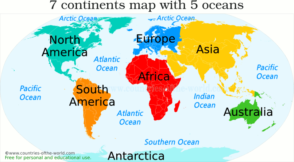
7 continents of the world
The widely recognized all the 7 continents are listed by size below, from biggest to smallest.
ASIA includes 50 countries, and it is the most populated continent, the 60% of the total population of the Earth live here.
AFRICA comprises 54 countries. It is the hottest continent and home of the world’s largest desert, the Sahara, occupying the 25% of the total area of Africa.
NORTH AMERICA includes 23 countries led by the USA as the largest economy in the world.
SOUTH AMERICA comprises 12 countries. Here is located the largest forest, the Amazon rainforest, which covers 30% of the South America total area.
ANTARCTICA is the coldest continent in the world, completely covered with ice. There are no permanent inhabitants, except of scientists maintaining research stations in Antarctica.
EUROPE comprises 51 countries. It is the most developed economically continent with the European Union as the biggest economic and political union in the world.
AUSTRALIA includes 14 countries. It is the least populated continent after Antarctica, only 0.2% of the total Earth population live here.
| # | Continent | Area (km2) | Area (mi2) |
|---|---|---|---|
| 1 | Asia | 44,579,000 | 17,212,000 |
| 2 | Africa | 30,370,000 | 11,726,000 |
| 3 | North America | 24,709,000 | 9,540,000 |
| 4 | South America | 17,840,000 | 6,890,000 |
| 5 | Antarctica | 14,000,000 | 5,405,000 |
| 6 | Europe | 10,180,000 | 3,930,000 |
| 7 | Australia | 8,600,000 | 3,320,000 |
| # | Continent | PopulationJanuary 2022 | Population Prospects2050 |
|---|---|---|---|
| 1 | Asia | 4,689,397,900 | 5,351,916,300 |
| 2 | Africa | 1,387,393,400 | 1,850,475,700 |
| 3 | Europe | 746,129,000 | 700,676,200 |
| 4 | North America | 597,677,700 | 662,334,900 |
| 5 | South America | 435,083,400 | 509,254,300 |
| 6 | Australia | 43,398,700 | 49,423,700 |
| 7 | Antarctica | no permanent population | no data |