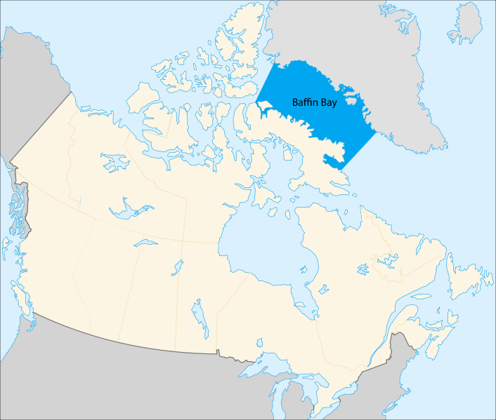
Baffin Bay, arm of the North Atlantic Ocean with an area of 266,000 square miles (689,000 square km), extending southward from the Arctic for 900 miles (1,450 km) between the Greenland coast (east) and Baffin Island (west). Of about 20,000 beluga whales living in the Baffin Bay, some 15,000 are concentrated at the North Water. Other abundant animals of the region include walrus, narwhal, harp seal, bearded seal, ringed seal, bowhead whale, rorquals and polar bear.
The icy habitat of Baffin Bay and Davis Strait is an ideal home for globally important populations of bowhead whales, narwhals, fish, seabirds and cold water corals. More than 17,000 people (48 per cent of Nunavut’s population) live here and on small surrounding islands in nine coastal communities including Iqaluit, the territory’s capital and only city.
Baffin Island lies in the path of a generally northerly airflow all year round, so, like much of northeastern Canada, it has an extremely cold climate.
Baffin Bay (Inuktitut: Saknirutiak Imanga: Greenlandic: Avannaata Imaa French: Baie de Baffin),[a] located between Baffin Island and the west coast of Greenland, is defined by the International Hydrographic Organization as a marginal sea of the Arctic Ocean.: Art.23 It is sometimes considered a sea of the North Atlantic Ocean. It is connected to the Atlantic via Davis Strait and the Labrador Sea. The narrower Nares Strait connects Baffin Bay with the Arctic Ocean. The bay is not navigable most of the year because of the ice cover and high density of floating ice and icebergs in the open areas. However, a polynya of about 80,000 km2 (31,000 sq mi), known as the North Water, opens in summer on the north near Smith Sound. Most of the aquatic life of the bay is concentrated near that region.
Extent
The International Hydrographic Organization defines the limits of Baffin Bay as follows:[6]
On the North. A line from Cape Sheridan, Grant Land (82°35′N 60°45′W) to Cape Bryant, Greenland.
On the East. The West Coast of Greenland.
On the South. The parallel of 70° North between Greenland and Baffin Land.
On the West. The Eastern limits of the North-West Passages [The East Coast of Ellesmere Island between C. Sheridan and Cape Norton Shaw (76°29′N 78°30′W), thence across to Phillips Point (Coburg Island) through this Island to Marina Peninsula (75°55′N 79°10′W) and across to Cape Fitz Roy (Devon Island) down the East Coast to Cape Sherard (Cape Osborn) (74°35′N 80°30′W) and across to Cape Liverpool, Bylot Island (73°44′N 77°50′W); down the East coast of this island to Cape Graham Moore, its southeastern point, and thence across to Cape Macculloch (72°29′N 75°08′W) and down the East coast of Baffin Island to East Bluff, its Southeastern extremity, and thence the Eastern limit of Hudson Strait].
— International Hydrographic Organization, Limits of Oceans and Seas, 3rd edition
How cold does Baffin Island get?
Fall and spring weather is variable, with temperatures between 0°C and -30°C. The snow begins to melt in May, but the sea ice doesn’t break up until the end of July. Winter temperatures hover around -35°C yet can sometimes drop to -50°C on very rare occasions.
What language is spoken in Baffin Island? Inuktitut
Inuktitut is a language commonly spoken by many Baffin Island Inuit. The language has several subdialects, including North and South Baffin. According to the 2016 census, 36,015 people of the Indigenous population reported Inuktitut as their mother tongue.
Who owns Baffin Island? Nunavut territory, Canada
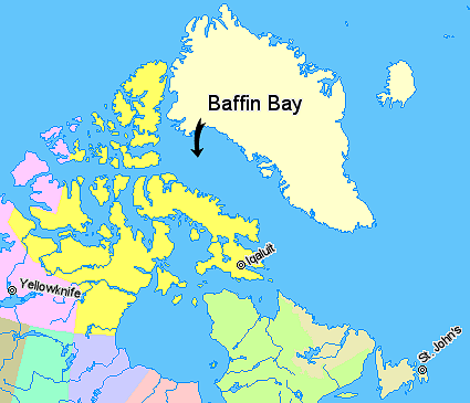
Baffin Island is separated from Greenland on the north and east by Baffin Bay and Davis Strait and from the Labrador-Ungava mainland on the south by Hudson Strait. It is administered as part of Baffin region, Nunavut territory, Canada.
Do you get paid to live in Nunavut?
If you own your own home and occupy it as your principal residence or if you pay full rental cost of a unit, you get a monthly allowance of $400.
Is it always cold in Nunavut?
The weather in Nunavut varies greatly depending on the season and where you are in the territory. Winters can be very harsh, with average temperatures of -32°C in Pond Inlet and -27°C in Iqaluit. Summers can be quite mild, with temperatures ranging from an average of 11°C in Baker Lake in July to 6°C in Hall Beach.
Can you immigrate to Nunavut?
Currently, Nunavut does not have a Provincial Nominee Program (PNP) to nominate foreign nationals for permanent residence in the territory. However, if you are interested in settling down in Nunavut, you can do so through the available federal immigration pathways.
Is Baffin Bay fresh water?
Circulation is generally anticlockwise; off Greenland, relatively warm, salty water moves north, while along Baffin Island, cold, fresher water originating from the Arctic Ocean flows south.
Do people live on Baffin Island Canada?
Although it’s the fifth largest island in the world (and the largest in Canada), Baffin Island remains a mystery to many. Most of the island’s population of 11,000 live in the capital of Iqaluit, leaving the vast majority of its land surface uninhabited.
How do I get to Baffin?
The most common way to explore Baffin Island and the rest of the High Arctic is with an Arctic cruise. Arctic cruises are the most common (and easiest) way to visit the island; they are not the only way. But there are other adventurous tours to choose from to discover Baffin Island.
What is the coldest area in Canada?
The coldest place in Canada based on average yearly temperature is Eureka, Nunavut, where the temperature averages at −19.7 °C or −3.5 °F for the year. However, the coldest temperature ever recorded in Canada was −63.0 °C or −81.4 °F in Snag, Yukon.
Does it get dark in Nunavut?
Thanks to being so far north, much of Nunavut experiences extremely short days between October and February—receiving, at times, only about four hours of daylight. While this might be bad news if you’re afraid of the dark, it’s great news for those wishing to see the Aurora Borealis in action.
Is Nunavut the coldest place in the world?
According to a new weather report from WX-Now, which tracks the world’s most extreme weather, one place in Russia is the only spot outside of Canada that made Thursday’s list. The coldest place on the planet today is Rea Point in Nunavut with a brutal -41ºC, and factor in the wind chill and it’s a mind-numbing -52°C.
What animals live in Baffin Island?
Baffin Island wildlife includes polar bears, Arctic foxes, caribou, Arctic hares, seals, walruses, Arctic wolves and of course whales—narwhals, orca, beluga and bowhead.