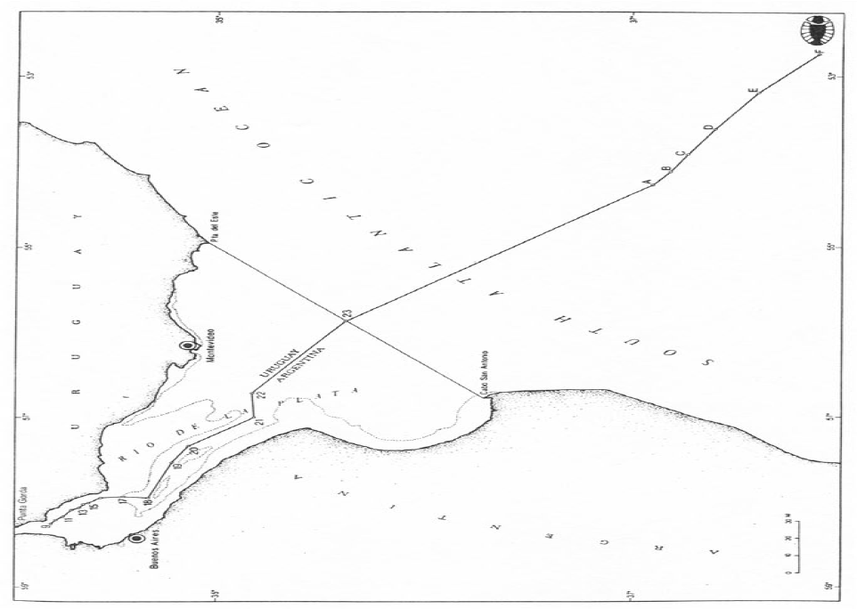
In 1973 Argentina and Uruguay concluded an agreement (1973 Agreement) concerning overlapping claims to the Río de la Plata and maritime zones seaward of a closing line at the mouth of the river. Seaward of the closing line, the 1973 Agreement establishes a ‘lateral maritime boundary’ and boundary of the continental shelf, which are both defined by a single equidistance line. The closing line and lateral maritime boundary are depicted in Figure. The lateral maritime boundary delimits several jurisdictional competencies recognized in the Agreement, which relate to: the exploration, conservation, and exploitation of resources; control and supervision of fishing activities; protection and preservation of the environment; scientific research; and construction and emplacement of installations. Viewing this delimitation of competencies in light of LOSC Part V, it is reasonable to regard the lateral maritime boundary as a delimitation of the EEZ and associated coastal state jurisdiction.
Design features of provisional joint management frameworks:
The 1973 Agreement also establishes a ‘common zone’ straddling the lateral maritime boundary, with a framework of cooperation regarding fishing activities, scientific research and environmental protection. Provisions concerning management of the maritime area landward of the closing line (the river area) are subject to overlapping claims to internal waters. The jurisdictional status of the river area is not, however, clear given that (1) several States dispute the river area’s characterization as internal waters and (2) in response to these protests, Argentina and Uruguay have confirmed their respect for the freedom of navigation in the river area.
Article 2 of the 1973 Agreement establishes a ‘coastal belt’ of exclusive jurisdiction of variable width adjacent to each Party’s coast within the river area. Articles 3-6 employ a complex combination of several criteria to determine the existence of national jurisdiction beyond these coastal belts.
The Articles provide as follows:
Article 3.
Outside the coastal belts, each Party’s jurisdiction shall also apply to vessels flying its flag. The same jurisdiction shall also apply to vessels flying the flags of third parties involved in accidents with that Party’s vessels. Notwithstanding the provisions of the first and second paragraphs, the jurisdiction of one Party shall apply in all cases in which its security is affected or in which unlawful acts are committed which have effect in its territory, regardless of the flag flown by the vessel involved. Where the security of both Parties is affected or the unlawful act has effect in both territories, the jurisdiction of the Party whose coastal belt is closer than that of the other Party to the place where the vessel was apprehended shall apply.
Article 4.
In cases not covered in article 3 and without prejudice to the specific provisions of other articles of this Treaty, the jurisdiction of either Party shall apply according to the criterion of greater proximity of one or the other coastal belt to the place in which the events in question occur.
Article 5.
The supervising authority which discovers an unlawful act may pursue the offending vessel up to the limit of the coastal belt of the other Party. If the offending vessel enters that coastal belt, the co-operation of the other Party shall be sought and that Party shall in all cases hand over the offender so that he can be brought before the authority which initiated the pursuit.
Article 6.
The authorities of one Party may seize a vessel flying the flag of the other Party when the latter is caught in flagrant violation of the provisions governing fishing, conservation and preservation of living resources, and pollution, in force in their shared waters and shall notify that Party immediately and place the offending vessel at the disposal of its authorities.
The 1973 Agreement also establishes cooperative frameworks concerning the joint management of navigation and works in the river area, vessel pilotage, search and rescue operations, vessel salvaging, pollution, fishing, and marine scientific research. A joint Administrative Commission with international legal personality is empowered to perform several functions concerning the implementation and operationalization of these cooperative frameworks. The Commission is also empowered to consider disputes arising between the Parties ‘concerning the Rio de la Plata’ in accordance with a compulsory conciliation procedure.
Article 41 of the 1973 Agreement designated a delimitation line for the seabed and subsoil of the river area. Each Party is entitled to explore and exploit the resources of the seabed and subsoil on their respective side of the delimitation line provided that installations or other works do not interfere with navigation in the river area. Mineral deposits found to be straddling the delimitation line are to be shared ‘proportionally’ between the two States.(1973 Agreement, Article 43.)
In 1988, the Parties concluded an agreement entrusting the Administrative Commission with the task of designating a maritime boundary between two small islands (Martin Garcia Island and Timoteo Dominguez Island, located near Buenos Aires) in the river area. The author is not aware if this designation has been effected. Comment concerning functional coverage:
The 1973 Agreement contains provisions allocating coastal State competence and/or jurisdiction within the relevant OCA in a complete set of functional contexts. It specifies the terms on which Argentina and Uruguay are to implement within the relevant OCA all of the functional components of their coastal State jurisdiction.