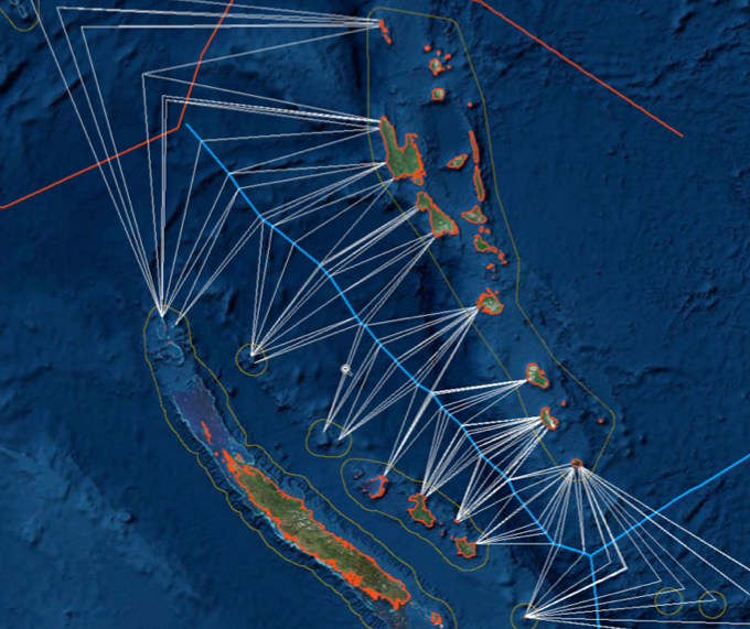
Definition
Maritime delimitation may be defined as the process of establishing lines separating the
spatial ambit of coastal State jurisdiction over maritime space where the legal title overlaps
with that of another State. This definition calls for three comments.
First, a distinction must be made between maritime limits and maritime delimitation. The
establishment of maritime ‘limits’ consists of drawing lines that define the maritime spaces of
a single State, that is to say, spaces that are not in contact with those of another coastal State.
The establishment of ‘limits’ is by its nature a unilateral act. On the other hand, ‘maritime
delimitation’ is an operation to be effected between two or more States, because its object is to
separate overlapping areas where legal titles of coastal States compete and each State
attempts to exercise spatial jurisdiction over the same maritime space.
Second, maritime delimitation is international by nature since it must be effected by
agreement between relevant States. The Chamber of the ICJ in the Gulf of Maine case
affirmed this point, by stating: ‘No maritime delimitation between States with opposite or
adjacent coasts may be effected unilaterally by one of those States.’ Hence, maritime
delimitation is international by nature.
Third, according to the definition given, the phenomenon of maritime delimitation is
confined to States. Accordingly, delimitation issues among the members of federations fall outside the scope of this chapter. For the same reason, international organisations, among
others the International Seabed Authority, are not subjects of maritime delimitation.
Typology of Maritime Delimitation
Under the 1958 Geneva Conventions and the 1982 LOSC, four types of maritime delimitation
can be identified:
(i) Delimitation of the territorial sea (Article 12 of the Convention on the Territorial Sea
and the Contiguous Zone (hereinafter the TSC); Article 15 of the LOSC),
(ii) Delimitation of the contiguous zone (TSC, Article 24),
(iii) Delimitation of the continental shelf (Article 6 of the Convention on the Continental
Shelf; LOSC, Article 83), and
(iv) Delimitation of the EEZ (LOSC, Article 74).
These treaties contain no provision with regard to the delimitation of internal waters,
although that problem may arise, for instance, in the case of a bay with several riparians.
In addition to this, the single maritime boundary, which would delimit the continental shelf
and the EEZ/fishery zone (FZ) by one line, is at issue. Considering that the factors to be
taken into account may be different for the seabed and superjacent waters, it seems possible
that the delimitation line of a continental shelf and an EEZ/FZ would differ as well.
A divergence of factors relevant to the seabed and the superjacent waters may entail the
risk of creating two competing lines dividing coincident areas and create a situation in
which part of the EEZ belonging to one State may overlap part of another State’s continental
shelf. Such a situation would give rise to complex problems relating to jurisdiction.
The same problem arises in the application of customary law. In practice, there is a clear
trend that States draw a single maritime boundary for the continental shelf and the EEZ/FZ.

