(1) List of geographical coordinates of points between which straight baselines are to be drawn for the purpose of determining the innermost limits of the territorial seas of Rotuma and its dependencies, as contained in the Marine Spaces (Territorial Seas) (Rotuma and Its Dependencies) Order (based on the World Geodetic System 1972 (WGS 72) datum, plus 3 seconds of latitude and plus 2 seconds of longitude in each case);
(2) List of geographical coordinates of points between which straight baselines are to be drawn for the purpose of determining the outermost limits of the archipelago waters of Fiji and the innermost limits of the territorial sea of the Fiji archipelago, as contained in the first schedule (paragraph 2) annexed to the Marine Spaces (Archipelagic Baselines and Exclusive Economic Zone) Order (based on the World Geodetic System 1972 (WGS 72) datum, minus 7 seconds of latitude and 14 seconds of longitude in each case); and
(3) List of geographical coordinates of points between which, when joined in a numerical sequence, a line is drawn up to which extend the outer limits of the exclusive economic zone of Fiji, as reflected in the second schedule (paragraph 3) contained in the Marine Spaces (Archipelagic Baselines and Exclusive Economic Zone) Order (based on the World Geodetic System 1972 (WGS 72) datum).
Fiji’s legislation establishes two different types of baselines. Archipelagic baselines join most of the country’s islands to form the Fiji Archipelago; seaward of those baselines is the territorial sea and high seas, landward of them are archipelagic waters and internal waters.
The other type of baseline delimits the internal waters from archipelagic waters (if situated inside archipelagic baselines) or from the territorial sea (as in the Rotuma Island area).
The archipelagic straight baseline system comprises 34 turning points and connects the outer point of the outer islands and drying reefs. Legal Notice 117 (paragraph 2) states that the geographical coordinates of the basepoints are based on the World Geodetic System 1972 (WGS72) and that the listings given in the First Schedule are correct, minus 7 seconds of latitude and 14 seconds of longitude in each case. The distance between basepoints ranges from 1.0 nautical miles (between points 19 and 20) to 119.9 nautical miles (between points 15 and 16), with a mean length of 27.7 nautical miles (see Annex 3 for a listing of the distances between the archipelagic turning points). The baseline length criterion cited in Article 47(2) of the LOS Convention is met. This paragraph states:
“The length of such baselines shall not exceed 100 nautical miles, except that up to 3 percent of the total number of baselines enclosing any archipelago may exceed that length, up to a maximum length of 125 nautical miles.”
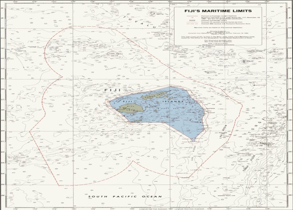
These baselines, along with the depiction of the internal waters and the territorial sea limit, are officially illustrated on Fiji Marine Spaces Chart 81/2 which is based on British Admiralty Chart 2691, 1970. The attached chart (which does not show the internal waters) is based on US DMAHTC chart 605 and is produced solely for the purpose of this study.
According to Article 47(1) of the LOS Convention:
“An archipelagic State may draw straight archipelagic baselines joining the outermost points of the outermost islands and drying reefs of the archipelago provided that within such baselines are included the main islands and an area in which the ratio of the area of the water to the area of the land, including atolls, is between 1 to 1 and 9 to 1.”
It would appear that Fiji’s archipelagic baseline system meets these requirements. As shown on Fiji’s Marine Spaces Chart 81/2, 30 of the 34 baseline turning points seem to be located on drying reefs and only 4 turning points (Nos. 1, 8, 26, and 33) fall on land. The total area enclosed by the archipelagic baselines is approximately 174,300 square kilometers (50,900 sq. nautical miles). Based on Fiji’s internal waters claim this area includes the following components3:
Land = 18,272 sq. kilometers
Internal waters = 25,558 sq. kilometers
Archipelagic waters = 130,470 sq. kilometers
For
the purpose of calculating the water-to-land area ratio, Article 47(7) allows the use of “waters lying within the fringing reefs of islands and atolls….” In Fiji’s case these waters, claimed as internal waters, are about 1.4 times the total land area. The resulting water-area-to-land-area ratio is well within the LOS Convention range:
130,470: 43,830 = 2.98: 1.
It is with respect to fringing reefs that most of the questions regarding the internal baselines arise. Article 6 of the LOS Convention provides:
“In the case of islands situated on atolls or of islands having fringing reefs, the baseline for measuring the breadth of the territorial sea is the seaward low-water line of the reef, as shown by the appropriate symbol on charts officially recognized by the coastal State.”
A fundamental omission from the LOS Convention is a provision designating appropriate reef closing lines similar to the provisions given for “rivers” and “bays” found in Articles 9 and 10, respectively. Many of the reefs surrounding Fijian islands extend from the land and are unbroken physical features. Other reefs, however, contain one or several entrances to the lagoons that they surround. Fiji arbitrarily has drawn closing lines for these reef entrances. Depending on one’s interpretation of the LOS text, it may be questionable whether Fiji can legally claim much of the enclosed waters as internal. An examination of the Fijian chart shows at least four areas where Fiji’s claimed internal water baseline may be somewhat far reaching.
The first area is at the Heemskercq Reefs (not labeled on the attached map), located near the northeast corner of the archipelago, east of Vanua Levu. Although there may be a problem of chart symbol interpretation, the baseline appears to follow along a symbol depicting a submerged feature for about 13 nautical miles.
Off the west coast of Vanua Levu an internal water baseline has been drawn along the Pascoe Reefs (to the southwest of the Great Sea Reef). Across Round Island Passage, to the east of Yasawa Group, internal water baselines have been drawn along an area labeled Tivolei on the Fiji chart. In both areas the chart symbols indicate submerged features rather than drying reefs. And finally, south of Viti Levu the small island of Mbengga contains two internal water baselines that do not appear to follow along drying reefs. To conform to the LOS Convention it would appear that some adjustments to the internal water baseline should be made, adjustments that would not affect significantly the archipelagic water to land area ratio.
The baseline for Ceva-i-Ra is the low-water line of the drying reefs that surround the island. The island itself measures only about 100 meters by 325 meters, and the internal waters enclosed by the claimed baselines are approximately 2.5 sq. kilometers.
The baseline claimed by Fiji for its northern island of Rotuma may be questionable. In the Marine Spaces Act Rotuma is defined as the “Rotuma archipelago” comprising Rotuma and its dependencies, which include about six smaller islands situated between 1.5 and 4.5 nautical miles to the west of Rotuma. Currently before Fiji’s Parliament is an amendment to the Marine Spaces Act which, inter alia, deletes reference to Rotuma as an archipelago. Instead, the waters within the baselines are intended to be internal waters and not archipelagic waters. The baselines are shown on Fiji Marine Spaces Chart 81/1 titled, “Chart Showing Basepoints and Straight Baselines Enclosing the Internal Waters of Rotuma.” An unofficial sketch of this map is provided in this study (following this page) for illustrative purposes only.
The legal-geographical basis on which Fiji claims much of these waters as internal highlights an interpretative problem posed by terms of the LOS Convention text. There is a reef system immediately off the island of Rotuma and essentially attached to the island. Distinct from and separated by waters with depths of greater than 20 fathoms (120 feet) are the several smaller islands situated to Rotuma’s west. According to Article 7(1) of the LOS Convention text, a state may draw straight baselines, “In localities where the coastline is deeply indented and cut into, or if there is a fringe of islands along the coast in its immediate vicinity….” No definition is given for a “fringe of islands.” Although the distances involved in this claimed straight baseline system are modest in global terms (see Annex 4 for a listing of distances between turning points), it is questionable whether the small islands situated to the west of Rotuma constitute a “fringe of islands.”