Treaty on the delimitation of the frontier for the part not indicated as such in the Peace Treaty of 10 February 1947 (with annexes, exchanges of letters and final act). Signed at Osimo, Ancona, on 10 November 1975
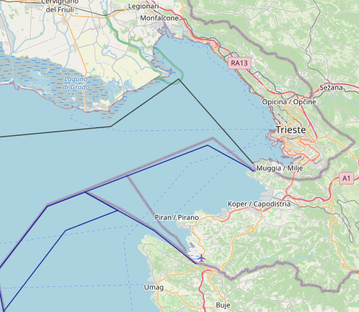
The maritime boundary between Italy and Slovenia was originally established through a bilateral agreement between Italy and Yugoslavia that was reached in 1975. The boundary extends for 15 nautical miles and is located entirely within the territorial sea of both States. The boundary delimitation was based on a slightly modified version of an equidistance line, and its termination point was formally defined by the 2017 Arbitral Award in the Croatia v. Slovenia land and maritime dispute case. The Arbitral Tribunal officially defined the tripoint between Croatia, Slovenia, and Italy to be located at “Point B” of their boundary award line, with coordinate values of 45° 33′ 57.4″ N, 13° 23′ 04.0″ E.


Maritime boundaries in the Adriatic
In the period following the WW II there were just three coastal states in the Adriatic.
The total of 3737 km of coast was shared between former Yugoslavia (56%), Italy (33%)
and Albania (11%). A small number of coastal states should theoretically enhance the
prospects for co-operation, but it did not flourish as it might have been expected. This
was largely the consequence of the fact that each of the coastal states had distinct ideological
orientations and geopolitical codes. Italy was a part of NATO alliance, Albania
was a rigid communist state, initially a Warsaw Pact member and later on a dissident
of the Soviet bloc with a strong isolationistic policy. Yugoslavia, ideologically a
“soft-communist” state, maintained a neutral position between the East and the West,
while co-operating with both sides. With regard to developments in the maritime boundary
system, this political context meant that the only bilateral achievements between
the Adriatic states were delimitations settled between Italy and Yugoslavia. Due to its
unfriendly foreign policy, Albania did not want to delimit its maritime boundaries.
Remaining maritime jurisdiction and their limits, namely territorial seas and baselines,
were proclaimed unilaterally.
All three coastal states proclaimed territorial sea. Albania initially proclaimed territorial
sea which extended 15 nautical miles. In 1990 Albania corrected the breadth of territorial
sea to the conventional 12 nautical miles. Italy in 1974 and former Yugoslavia in
1979 proclaimed their 12 nautical miles territorial seas. The straight baselines were also
adopted by all sides. Yugoslavia completed its baseline system, the most complex of the
three, in 1965. Albania proclaimed its baseline system in 1970 and modified it in 1976.
Finally, Italy proclaimed its system in 1977. Besides Adriatic coast, Italian baseline system
extends to Ionian and Tyrrhenian sea. Detailed overview of the straight baselines
and territorial sea in the Adriatic was provided by Blake and Topalović (1996).
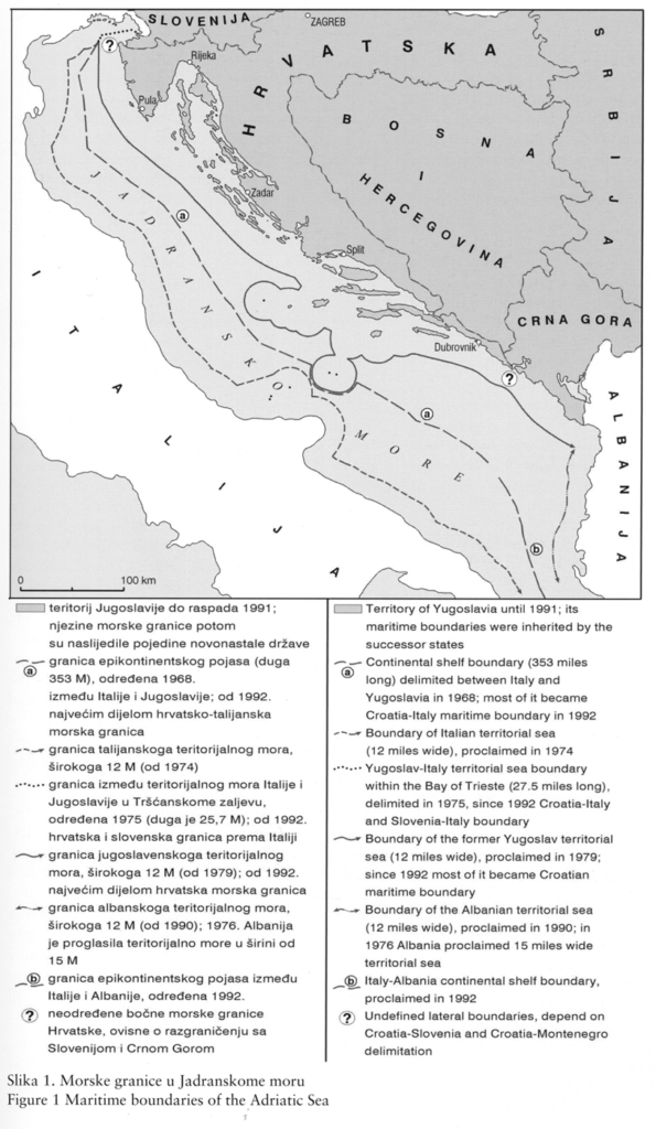
The agreement between Italy and Yugoslavia, signed in 1968 and entered into force
in 1970, was the first treaty concluded for the delimitation of the continental shelf in
the Mediterranean. The boundary line extended for 353 nautical miles, and basically
was equal to equidistant line. A more complex delimitation was needed only in the central
Adriatic in order to compensate Italy for the effect of Yugoslav open-sea islands of
Jabuka and Palagruža. The parties agreed not to extend the boundary south of Point 43
because Albania might have its interest. The parties to the treaty also decided to leave
open the territorial sea boundary in the Gulf of Trieste, taking into account that delimitation
of the Italy-Yugoslavia land border was only provisionally resolved at the time
when the treaty was concluded. Blake (1993/94) has emphasized the agreement was
widely considered as a fair and mutually satisfactory delimitation (Blake, 1993/94).
The northernmost section of the Italy-Yugoslavia maritime boundary, the territorial
sea boundary in the Gulf of Trieste, was agreed upon by the Treaty of Osimo in 1975
which was concluded mainly to put an end to the longstanding issue of land boundary
delimitation between the two countries. The boundary line connects five points.
Terminal point 5 has the same co-ordinates as starting point 01 of the 1968 continental
shelf agreement.
Redrawing of the European political map in the period of geopolitical transition, which
came following the collapse of bipolar world and demise of communism, created new situation
in the Adriatic. A number of coastal states doubled. Former Yugoslav coast was
divided into Slovenian, Bosnian, Montenegrin, and, immensely longest Croatian part.
Croatia inherited about 85% of Yugoslav coast (1780 km) and practically all the islands.
Such a long coastline ranks Croatia at the first or second position among “new” European
states, depending on whether one counts islands or not (Blake, 1993/94).

Most of the present-day off-shore boundaries were initially parts of former
Yugoslavia-Italy boundary agreed in 1970’s (Figure 1). The former Italy-Yugoslavia
maritime delimitations remained in place and were unaffected by the dissolution of
Yugoslavia. On the basis of the principle of succession, the formerly integral
Italian-Yugoslav boundary line through the Adriatic has been inherited as the
Italy-Slovenia, Italy-Croatia and Italy-Montenegro maritime boundary. Although the
succession has not been confirmed by a formal document, none of the sides involved
have expressed any legal, political, geographical or other reason to claim revision.
In 1992 Albania and Italy concluded the agreement on maritime delimitation of continental
shelf. The boundary was agreed on the basis of the principle of equidistance
that is expressed by the median line. It was simple and clear case of delimitation, easily
reached under the new geopolitical circumstances following international opening of
Albania.

