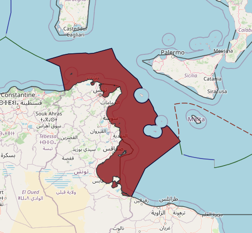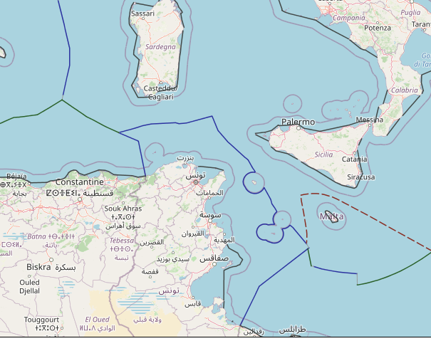
The Italy–Tunisia Delimitation Agreement is a 1971 treaty between Italy and Tunisia in which the two countries agreed to delimit a maritime boundary between them in the continental shelf. The text of the treaty sets out a complex boundary in the Strait of Sicily representing an equidistant line between Sicily and Tunisia, with the exception of Pantelleria and the Pelagie Islands (Lampedusa, Linosa and Lampione) treated as Italian exclaves in the Tunisian side with specific arcs of territorial sea. The boundary was primarily based on the equidistance methodology, constructed between the mainland coast of Tunisia and the large Italian islands of Sicily and Sardinia. Italy’s smaller mid-sea islands of Pantelleria, Lampedusa, Linosa, and Lampione were all enclaved so as to not inequitably skew the line in Italy’s favor. These islands all received 13 M enclaves with the exception of Lampione, which was only allotted a 12 M territorial sea. The boundary extends through the central Mediterranean Sea for 531 M and currently has no defined tripoints with neighboring States on either end, specifically Algeria in the west and Malta in the east.
The boundary terminates just short of an equidistant line between Malta and the Italian Pelagie Islands and the westernmost point of the boundary line forms a maritime tripoint with Algeria. On 23 January 1975, the countries by agreement added supplemental minutes to the treaty, including a map of the boundary and 32 individual coordinate points that define it. It came into force on 6 December 1978 after it was ratified by both countries.
The treaty was signed in Tunis on 20 August 1971 and its full name is the Agreement between the Government of the Republic of Tunisia and the Government of the Italian Republic concerning the Delimitation of the Continental Shelf between the two Countries.
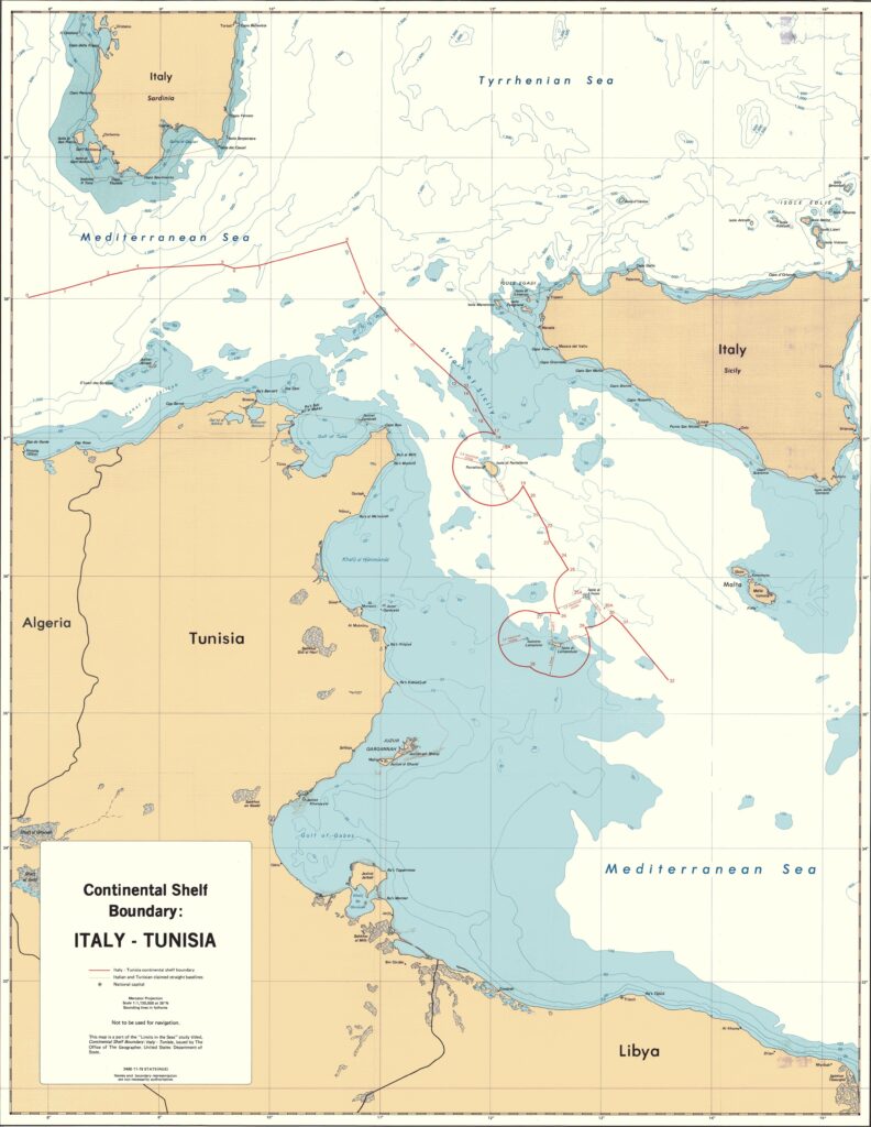
The Italy-Tunisia continental shelf boundary has been depicted on the attached map, which is based on United States DMAHTC charts 52020 and 53020. The straight lines drawn on the map are rhumb lines. According to the treaty annex, however, the boundary is comprised of segments of great circles as well as arcs developed around the relevant islands. For this analysis, geodesic distances have been calculated by computer on a spheroid different from the one utilized by the two countries. Slight discrepancies may, therefore, appear in any comparison.
The continental shelf boundary extends for a total distance of 443.36 miles. In the north it runs in an east-west direction and is situated between Tunisia’s north coast and the Italian island of Sardinia. The boundary then turns southeasterly and runs through the Strait of Sicily between the northeast coast of Tunisia and Sicily. Farther to the south the boundary arcs around and to the west of four Italian islands to terminate at a point approximately 50 miles east of the nearest Italian basepoint on Lampedusa, 114 miles east of Tunisia’s nearest basepoint, 101 miles south of Sicily’s, 51miles southwest of Malta’s, and approximately 135 miles north of Libya’s.
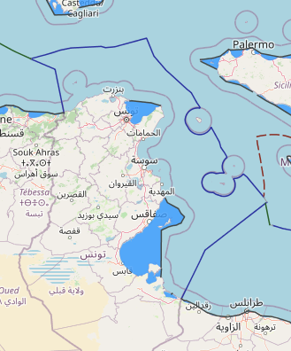
The boundary, according to the treaty, is to follow, with noted exceptions, a median line. Italy and Tunisia have agreed that the Italian islands of Pantelleria, Linosa, Lampedusa, and Lampione, all situated near the Tunisian mainland, constitute a special circumstance. This causes a true equidistant line, developed from all Tunisian and Italian basepoints, to follow a course much to Tunisia’s disadvantage. An equidistant line developed between Tunisia and Pantelleria, for example, would deflect the boundary to within 20 miles of the Tunisian mainland. Therefore, in the equidistant line calculation the two states agreed to disregard these four Italian islands. In the area of the islands the boundary deviates from equidistance, as developed from basepoints on Sicily and the Tunisian mainland, and follows the outer limits of maritime zones drawn around each of the four islands.
In effect, each of the islands has been given a territorial sea and contiguous zones, which Italy at the time claimed to be 12 miles in breadth. In addition, Pantelleria, Lampedusa, and Linosa have been given a 1-mile-wide continental shelf zone beyond the 12-mile zone.
This boundary is an example of two states, by agreement, having acknowledged the presence of special circumstances. The location of relatively small islands would have created an inequitable boundary under the equidistance method. Through negotiation, the states agreed to allow the islands to have limited maritime zones.
Both states have published laws relating to their baseline. Where applicable, these baselines, including coordinates, have been used in the present analysis. Although the Ecueil des Sorelles (small rocks situated off Tunisia’s north coast) have been used as basepoints for Tunisia’s territorial sea, it is questionable whether they have been used in this boundary delimitation. Whereas turning points 0 and 1 are basically equidistant from other Italian and Tunisia basepoints, they are 6 miles nearer to the Ecueil des Sorelles. Turning point 2 is almost 2 miles closer to these small rocks than to the other basepoints.
Although the boundary from point 0 to 13 is generally equidistant from the two coasts, it appears that it does deviate from a “true” equidistant line. In a “true” equidistant calculation the line must be equidistant at all times from one point on each coast. At the turning points, a “true” equidistant line must be equidistant from three basepoints–one on one coast and two on the other coast. There are several turning points in this boundary that appear to be equidistant from two basepoints, but not three.
Turning point 3, for example, calculates to be equidistant from the Tunisian Galitons de l’Est and Sardinia, but the Italian Isolatto il Toro is approximately 2.5 miles farther from the boundary at this point. Similarly, turning points 4, 5, 6, and 7 do not appear to be trijunctions.
From turning point 13 to turning point 18, the island of Pantelleria has been disregarded in the development of the equidistant line. Point 18 represents the intersection of the equidistant line with an arc drawn 13 miles from the baseline of Pantelleria; segment 18-19 has been developed by drawing 13-mile arcs from its baseline. From turning points 19 to 23, the boundary follows an equidistant line developed from the Tunisian mainland and the baseline of Sicily while disregarding the presence of Pantelleria.
At turning point 23, Linosa is closer to the median line than any other territory, but it also has been ignored in the development of the equidistant line. Boundary segments 25 to 27 follow the 13-mile arcs drawn from the baselines of Linosa and Lampedusa; segment 2728 follows the 12-mile arcs developed from the baseline of Lampione; segments 28-30 again follow the 13-mile arcs drawn from Lampedusa, and Linosa. While the final segments of the boundary–the lines connecting points 30-32–are again, according to the treaty, supposed to be equidistant from Sicily and Tunisia, it is evident from the calculation that this part of the boundary does not quite meet the requirements of a “true” equidistant line. At terminal point 32, the boundary is generally half the distance, and basically equidistant, from Lampedusa and Malta, than it is from Sicily and Tunisia. Malta and Italy have yet to delimit their maritime boundary.