Spain has a number of undelimited maritime boundaries with its neighboring States, including the States mentioned above, as well as Morocco and Algeria. The Morocco–Spain border consists of three non-contiguous lines totalling 18.5 km (11.5 m) around the Spanish territories of Ceuta (8 km), Peñón de Vélez de la Gomera (75 metres) and Melilla (10.5 km). These three exclaves form part of Spain’s plazas de soberanía, which also includes a number of small islands off the Moroccan coast.
Morocco does not recognize Spain’s claim to several Spanish enclaves on the Mediterranean coast of Africa, principally Ceuta and Melilla. Morocco claims Western Sahara and, since 1979, has administered the territory as its own, although the International Court of Justice ruled in 1975 that Morocco has no legitimate claim to Western Sahara. Having explored Spain’s position on the drawing of an equidistance line, we now need to consider Morocco’s understanding before addressing the State practice of these two countries. Morocco disagrees with the equidistance line, largely arguing that ‘the respective configuration of the Moroccan coasts lying opposite the coasts of the Canary Islands, constitutes a relevant circumstance of the geographic type established in Morocco’s legislation that allows Morocco to refuse the application of the equidistance method.
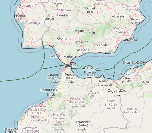
Morocco and Spain also share a maritime border in the Canary Islands area and along the Strait of Gibraltar and the Alboran Sea. The shortest distance between land along the Strait of Gibraltar is 14.3 kilometres (8.9 mi; 7.7 nmi). The British territory of Gibraltar (claimed by Spain) is located on the northern coast of this strait.
The pending maritime delimitations between Spain and Morocco are highly complex and noteworthy due to the existence of diverse factors, namely the particularity that the delimitations shall be conducted in two different seas: the Alboran Sea and the Atlantic Ocean. Moreover, various sovereignty issues must be addressed, such as the Spanish enclaves in North Africa, which are claimed by Morocco generating maritime entitlements, and the Western Sahara dispute and Morocco’s intention to include the Western Sahara maritime areas under its jurisdiction. In terms of the latter issue, this article studies the fisheries agreements concluded between the European Union and Morocco and the recent decisions given by the Court of Justice of the European Union, declaring those agreements prohibited under international law in respect of Western Sahara waters. Other significant matters analyzed are the views of both countries, the existence of several overlapping maritime claims with third States and the negotiations that have been carried out thus far to reach an agreement delimiting the maritime boundaries. On this subject, it is crucial to determine whether a tacit agreement exists – on the basis of the hydrocarbon activities licensed by Spain and Morocco – establishing the maritime boundary between the Canary Islands and Morocco’s Atlantic coast.
The maritime delimitation between Spain and Morocco in the Alboran Sea is particularly complex due to the existence of Morocco’s sovereignty claims over five Spanish territories in North Africa. Moreover, both States have argued for a different method of delimitation, namely the equidistance line (on the part of Spain) and the equitable principles (on the part of Morocco). This section will address the sovereignty issues, the repercussions of those issues for maritime delimitation, the situation in the Strait of Gibraltar, and the delimitation negotiations and some considerations about the potential alternatives .
The Strait of Gibraltar legal situation
In order to get to know the legal status applicable to the region and understand the controversies that its application may cause, we must analyze the physical features of the strait. For that purpose, we will draw a picture of the geographical framework of the marine spaces where both States exercise sovereignty and have jurisdictional rights. Thus, we must explain the meaning of the word “strait” from both geographical and legal points of view.
A strait is a natural channel of water between two coastlines; it is the result of a contraction of the sea, which separates two portions of land and connects two maritime areas. The Strait of Gibraltar is a narrow area of water that runs alongside 33 NM, separating the Southwestern extreme of Europe and the Northwestern extreme of Africa, where the Mediterranean Sea and the Atlantic Ocean meet. Its northern coast (between the Cape of Trafalgar and Europa Point – Rock of Gibraltar) has a length of 55 NM and its southern coast (between Cape Spartel and Santa Catalina Point – Ceuta) is 42 NM long. According to the Spanish Instituto Hidrográfico de la Marina, the western mouth of the Strait (between the Cape of Trafalgar and Cape Spartel) is 24.2 NM long, whereas the eastern part of the Strait (between Europa Point and Ceuta) is 12.5 NM; the narrowest part of the Strait, with a length of 7.45 NM, is the area located between Point Cires, in the South, and the median line between Tarifa and Guadalmesí river, in the North.
However, from the legal point of view, the concept of the Strait is more complex and it is defined by four concurrent factors: a) the existence of a strait, from the geographical point of view; b) its use as a navigation channel, which highlights the fact that it is a strait; c) the legal status of its waters; d) the regime of navigation it sets. In this sense, the United Nations Convention on the Law of the Sea of 1982 (UNCLOS) establishes a variety of legal status that can be applied to straits according to their waters and their legal nature. It establishes a difference between those with a broad regime of freedom of navigation (regime of transit passage) and those with a more limited regime of navigation (regime of innocent passage). The first regime is applied to the straits connecting “a high seas area or an area within an Exclusive Economic Zone (EEZ) with another high seas area or another area within an EEZ (such as the Strait of Malacca, or the Strait of Hormuz)”. This regime is applied to “those straits that are part of a high seas route or a route that goes through an EEZ”. The second regime is applied only to waters forming a strait between an island of a State and the mainland of that State, on one side, and a high seas route or a route through an EEZ, on the other side, and it can also be applied to straits between a high seas area or an EEZ and the territorial sea of another State, like the Strait of Corfu and the Strait of Tiran.
Regarding the Strait of Gibraltar, we could say that all its waters are under state sovereignty and/or state jurisdiction, which does not hinder navigation. The main characteristic of the legal status of its waters, as we will see later, is the freedom of navigation. This statement is based on the internal and international rules currently applicable in the zone. According to the Spanish Ley 10/77 de 4 de enero (BOE de 8 de enero de 1977) and Dahir portant Loi n.º 1-73-211 du Moharrem 1393 (2 mars 1973), the area of territorial sea corresponding to Spain and Morocco is 12 NM long from the coastlines of both countries. Moreover, the United Kingdom claims since 1878 a territorial sea of 3 NM around its colony in virtue of the Territorial Waters Jurisdictional Act. Morocco, on the other hand, has established EEZ in all its coasts, including the ones located in the Strait and in the rest of its Mediterranean shore by means of Dahir du 8 avril 1981). If we take all these data into account, there is no doubt that, from the geographical point of view, the waters of the Strait of Gibraltar are located in an area of waters under the sovereignty or under the jurisdiction of the coastal States.
Due to the factors mentioned, the Strait has the first legal status established by the UNCLOS that we have already explained: it connects a high seas area or an area within an EEZ with another high seas area or another area within an EEZ; in this kind of straits, the regime of transit passage is applied. The Strait of Gibraltar connects an area of the Atlantic Ocean where Morocco, Spain and Portugal have established EEZs that overlap, with Mediterranean waters, specifically the Alboran Sea, where only Morocco has established an EEZ.
POINTS WHOSE SOVEREIGNTY IS CONTROVERSIAL AND DELIMITATION OF SEA FRONTIERS
One of the most remarkable aspects in the study of this topic is the fact that there have been claims over small territories located in both sides of Strait for centuries. These claims have been affecting the relations between Spain, Morocco and the United Kingdom in an intermittent way; it is the case of Morocco, regarding the Spanish territory located in Ceuta and Perejil Island, and the case of Spain regarding the waters that surround the British colony of Gibraltar. We will now move on to the points whose sovereignty is controversial and their titles.
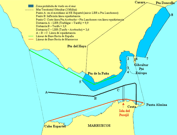
Perejil Island
Perejil Island, also known as Leïla Island or Toura Island, is a rocky islet that was originally part of the Yebel Musa Mountain. It is located 200 meters away from the Moroccan coast and less than 8 kilometers from Ceuta, between Almanza Point and Leona Point (one of the narrowest parts of the Strait of Gibraltar). There are two small inlets on its shore: the one on the north is called “Cala del Rey” and the one on the south is called “Cala de la Reina”, near which there still remain the ruins of a tower built during the Portuguese occupation. Historically, Perejil Island has been part of Spain; however, it has been inhabited since 1960’s. Due to its physical features (it cannot be inhabited by humans) and the lack of economic activity, this islet can be considered as a “rock” and not as an “island”, according to the Article 121 of the UNCLOS; this means that it does not belong to any continental platform or EEZ, but it does belong to a territorial sea of up to 12 NM and an adjacent area of up to 24 NM.
The legal status of Perejil Island is perhaps one of the most controversial ones in the Mediterranean Sea, and it is still a potential focus of conflict. The control of this territory has caused many confrontations throughout history; however, the most international one was the conflict that took place on July 11th 2002, when a group of Moroccan military men took control over the islet, clearly claiming sovereignty over the territory. That action led to an official complaint by the Diplomatic Information Office of the Spanish Ministry of Foreign Affairs; in addition, Spanish military men were sent there in order to move them away. That situation caused a bilateral crisis, the so-called Perejil crisis, which threatened to spread throughout the Mediterranean Sea. This crisis ended after the intervention of the US Secretary, Colin Powell, who sent letters to the Ministers of Foreign Affairs of Spain and Morocco, bringing about the compromise to restore and maintain the statu quo existing before July 2002 and taking both parts back to their initial position.
Bearing in mind all the circumstances mentioned, it is obvious that Spanish and Moroccan waters overlap. In practice, there is a situation of uncertainty and even potential conflict: according to Spain, this island is within its jurisdictional waters, whereas according to Morocco, the island is located in Moroccan waters and is considered to be part of the territory of the country. There is not a delimitation agreement; there are only confronted positions: each part recognizes itself to have rights over the waters that surround the island and ignores the claims of the other part. Anyway, according to the international rules, the limits of this geographic feature are determined by the imaginary, equidistant line between the Spanish territory and the Moroccan territory; Perejil’s territorial waters are thus connected with the waters projected by the Peninsula through a corridor of waters belonging to Spain.
The Spanish city of Ceuta
The city of Ceuta has an extension of 19 square kilometers. It has been part of the Spanish Crown since the 15th century; Portugal handed it over to Spain by the Treaty of Alcaçovas (1479-1480) and this transfer was reassured some years later with the Treaties of Tordesillas (1494) and the Convention of Sintra (1509). The Moroccan Government has been claiming this portion of the Spanish territory located in the African coast, in the middle of the Strait of Gibraltar has been, as well as the city of Melilla, the Rock of Vélez de la Gomera, the Rock of Alhucemas and the Chafarinas Islands, since 1956. Even though the territories mentioned are not in the United Nations’ list of non-self-governing territories, Morocco has pursued a policy of territorial claims since it became independent, which has been expressed not only through international declarations but also through its intern legislation and its policy of delimitation and exploitation of the marine spaces. An example of this is that Morocco has established baselines according to which Ceuta and some other Spanish territories are surrounded by Moroccan waters.
Leaving aside this legal-politic controversy, it is evident that Spain has sovereignty titles over the city of Ceuta, which is part of the Spanish territory and thus, like any other territory, it has rights to have a territorial sea, a contiguous zone, an EEZ and a continental platform. All the spaces mentioned overlap with the ones established by Morocco. Currently, Spain and Morocco have not reached an agreement. Given the situation, according to the Spanish legislation and the UNCLOS, it can be understood that the maritime frontiers of Ceuta are determined by the equidistant line between the coasts of Ceuta and the Moroccan coasts, which means that the territory of Ceuta is encapsulated inside Moroccan jurisdictional waters.
The British colony of Gibraltar
The legal regime of the waters of Algeciras Bay and particularly its delimitation is highly conditioned by the Spanish-British controversy regarding the colony of Gibraltar and the interpretation of the article 10 in the Treaty of Utrecht (1713), by which Spain handed over the full property of the city and the castle of Gibraltar, as well as its port and its fortress to the British Crown.
Gibraltar was occupied by the Castillian troops of Ferdinand IV in 1309. The Nazaries of Granada recovered it in 1333 and Gibraltar remained under Muslim sovereignty until 1462, when it was conquered by the Duke of Medina Sidonia. Since that moment and until 1704, it belonged to the Kingdom of Spain. In 1704, it came under British sovereignty, as it was conquered by the troops of Archiduke Charles during the secession war, which confronted the ones who supported the House of Bourbon and those who supported the House of Austria to occupy the Crown. This situation became formal in 1713, thanks to the Treaty of Utrecht.
One of the problems posed by the Colony of Gibraltar is, among others, the different interpretations that Spain and the United Kingdom make of the Article 10 of the Treaty of Utrecht and the controversial progressive occupation by the English of spaces that were not originally handed over and that affect the waters of the Strait. According to the British Government, “the fact that only the harbor of Gibraltar was handed over, without mentioning the territorial waters, is irrelevant, because it is widely accepted since some time ago that handing over a territory entails handing over its territorial waters as well, unless it has been specifically established the contrary”. Hence, the United Kingdom has extended its jurisdictional waters up to 3 NM around the Rock of Gibraltar and up to 2 NM in the Algeciras Bay, arguing that a maritime zone cannot be handed over without also handing over the rights of the neighboring maritime spaces.
Under this expansion policy, the United Kingdom delimitated unilaterally in the 19th century the waters of its colony, and it established the limits of the harbor of Gibraltar and marked them with buoys that connected San Felipe with the Old Harbor of Gibraltar. However, according to Spain, that action by the British is against International Law, as Spain believes that the controversy must be considered according to the 6th paragraph of the United Nations Resolution 1512 (XV), which reads: “Any attempt aimed at the partial or total disruption of the national unity and the territorial integrity of a country is incompatible with the purposes and principles of the Charter of the United Nations”. In addition, the Spanish Government has always been firm and has interpreted literally the Article 10 of the Treaty of Utrecht of 1713, recognizing the British sovereignty only over the waters of the harbor of Gibraltar. Spain has expressed this in many international protests and in the first clause of the final provisions of the Act of 4 January 1977, according to which “the present legal text cannot be interpreted as a recognition of any rights or situations whatsoever related to the maritime spaces of Gibraltar which are not included in the Article 10 of the Treaty of Utrecht of July 13th 1977, between the Crowns of Spain and Great Britain” (BOE de 8 de enero de 1977), as well as the act of ratification that the UNCLOS carried out in 1997.
LACK OF DEFINITION OF THE MARINE FRONTIERS AND DIFFICULTIES OF DELIMITATION IN THE STRAIT
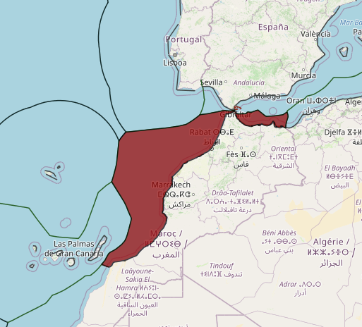
After having explained what the situation is, it is easier to understand the behavior of both the United Kingdom and the coastal States of the Strait. Each State acts according to its own interests and its own interpretation of its rights in the area, which makes it impossible to reach an agreement regarding the definition of marine frontiers. Hence, Morocco establishes unilaterally its jurisdictional limits in the sea as if Ceuta and Perejil Island were part of the Moroccan territory, so that the interior limits of its marine spaces (straight baselines and closing lines for the delimitation of bays) are within waters that are under Spanish sovereignty; Morocco considers those waters are Moroccan interior waters, whereas Spain considers they are Spanish territorial waters (see the red lines in the picture below). There is no doubt that the Dahir of 21st July 1975 in which Morocco draws these straight baselines (and thus, the interior limits of its marine spaces) is unenforceable to Spain, which presented a written diplomatic claim on 7th February 1976.
Something similar happens to Gibraltar, though both parts have more respect to the positions that the other part defends. The United Kingdom has fixed a strip of territorial waters of 3 NM around the Rock of Gibraltar, which is beyond the limits established in the Treaty of Utrecht; Spain, on the other hand, has not given up its position in the area and fixed the limits of the Algeciras-La Línea harbor in 1967 (Decreto 2671 de 19 de octubre, published in Diario Oficial de la Marina on 14th November 1967) but no delimitation agreement has been reached.
Taking into account all the facts mentioned, it can be stated that there is a paradoxical situation: three States with different points of view claim different territorial waters in that area, which causes a jurisdictional chaos in practice. The United Kingdom, on the one hand, defends its sovereignty in the north-eastern part; Spain, on the other hand, considers that there are only two coastal States in the Strait of Gibraltar; Morocco, in turn, also considers that there are two areas of sovereignty, but “in equal measure”, which implies not taking into account neither the Spanish sovereignty over Ceuta and Perejil Island nor the British presence in Gibraltar. This situation has resulted in an overlapping and a juxtaposition of the territorial waters of these States and thus, it has caused various types of conflicts (though not very serious): fishing conflicts (Morocco arrests Spanish fishermen who fish near Ceuta and Spain does the same with Moroccan fishermen, because both countries consider those waters are under their own jurisdiction); environmental conflicts, contraband and security conflicts, especially in the Algeciras Bay, where contrabandists escape the Spanish Guardia Civil by entering the jurisdictional waters of the colony. In addition, the recognition and delimitation of the marine spaces of Morocco has a great impact in bilateral relations, as in many occasions Morocco has used them to put pressure on some certain questions, such as the self-determination policy of the Sahara or the immigration and security agreements.
Given this situation, it is worth wondering where the limits of the Spanish territorial sea in the Strait are. From the Spanish point of view, the limits of the marine spaces in this area are determined by an equidistant line between the Spanish coast, the Moroccan coast and the British shore (in the colony). The result is a highly fragmented space in which the different sovereignties interrupt each other. If we apply the Ley 10/77 de 4 de enero del mar territorial (BOE de 8 de enero de 1977), we could state that the waters of Ceuta are connected to the waters that surround the Spanish continental territory. Furthermore, it is important to highlight that, as Perejil Island is surrounded by Spanish jurisdictional waters and it is very near the Moroccan coast, this creates a corridor of jurisdiction that connects vertically the Peninsula’s territorial sea with the island’s one.
THE LEGAL REGIME OF NAVIGATION IN THE STRAIT OF GIBRALTAR
Nowadays there are approximately 120 straits in the world; according to the extension of their territorial sea, 100 of them are within the jurisdiction of the international waters of coastal States. The Strait of Gibraltar is one of the Straits with the busiest international marine traffic in the world, with 250 ships crossing it each day. As we have already said at the beginning of this document, the Strait of Gibraltar is an area of exchange between the Mediterranean Sea and the Atlantic Ocean, which connects offshore areas and/or EEZ, just like the Straits of Ormuz, Bab el Mandeb, Bering or Malacca do. The UNCLOS establishes the regime of transit passage (part III, section 2, articles 37-44) for this type of straits, as we have already mentioned. According to this regime, the exercise of freedom of navigation and flight is allowed exclusively for purposes of quick and uninterrupted transit by those straits. However, this requirement does not impede the transit of ships to enter a coastal State of the Strait, or to go out of that State or go back to it, in conformity with the conditions that regulate the entry to that State (article 38.2).
Regarding transit passage of ships, these must comply with the international regulations, proceedings and practices that are widely accepted for security in the sea, which are aimed at preventing boardings and also reducing and controlling pollution (article 39.2 a and b). Regarding aircrafts, the article obliges civil aircrafts to comply with the regulations of the Air established by the International Civil Aviation Organisation (ICAO); State aircrafts must comply with those safety measures and shall always operate taking care of the security of navigation (article 39.3 a).
The Western Sahara Case
Western Sahara, known as “Spanish Sahara” until 1975, is the last colonial territory in Africa. Occupied
by Morocco and Mauritania that year after Spain’s withdrawal, its people have been unable to exercise
their right of self-determination under a United Nations sponsored process. The development of
Western Sahara’s natural resources has complicated matters. The nearby waters of the Atlantic Ocean
have a rich fishery and oil exploration in the seabed has begun. Does the exploitation of natural
resources prolong the Western Sahara conflict? Will such resources be available to the people of
Western Sahara at independence? the GIS application of current international
law to divide ocean areas by the drawing of maritime boundaries. The boundaries demarcate the 12
nautical mile (NM) territorial sea and a 200 NM exclusive economic zone (EEZ) for Western Sahara in
the Atlantic Ocean. In doing so, they illustrate the area that must be preserved from exploitation
pending the Saharan people’s self-determination.
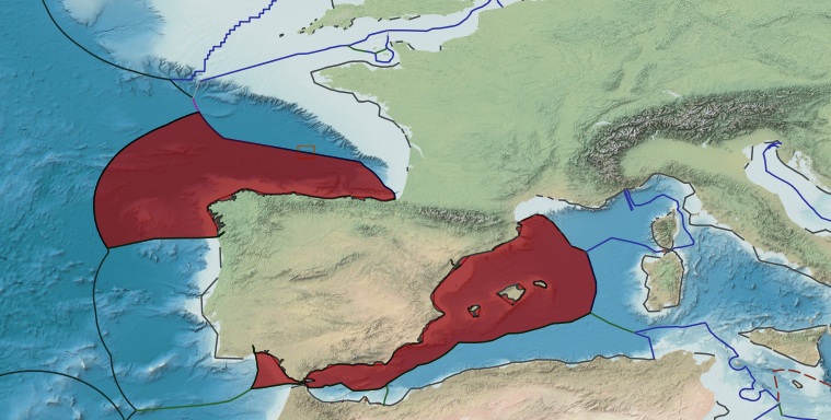
EEZ Claims in the Western Sahara Region
The 1982 UN Law of the Sea Convention – a multilateral “constitution” for use of the world’s oceans with 160
States having signed on – created the 200 NM EEZ. In the EEZ, a State has the exclusive right to explore and
exploit ocean resources, including fisheries, seabed petroleum and mineral deposits. There are four States which
claim 200 NM EEZs in the area of Western Sahara. maps shows how the four claims overlap, which are
complicated by the presence and archipelagic nature of Spain’s Canary Islands. Unless boundaries are
established to apportion these overlapping EEZ areas, each State can legitimately claim the natural resources of
its entire EEZ. This can lead to conflict, excessive exploitation resources, and no clear accountability for the
resources of Western Sahara, a territory that remains under occupation and whose people have not yet exercised
their right of self-determination.
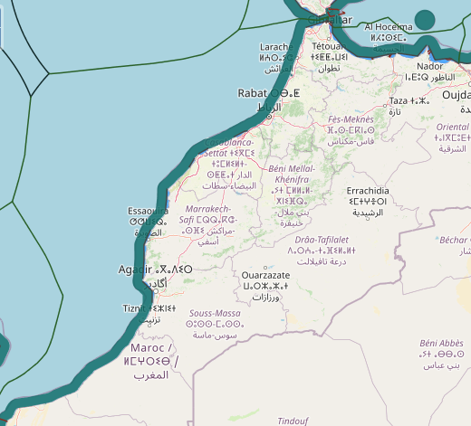
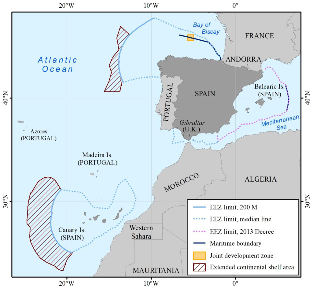
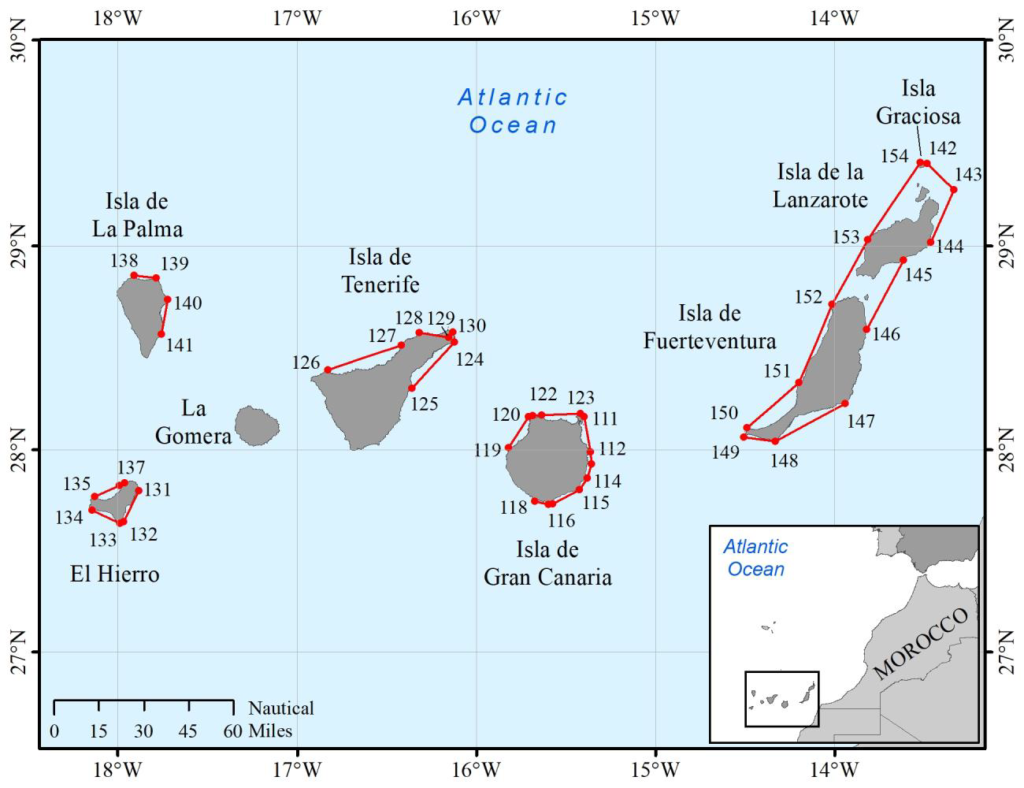
The Canary Islands constitute an archipelago in the Atlantic Ocean located approximately 560 M (1037 km) southwest of Spain’s mainland and 52 M (96 km) from the coast of Morocco. The Canary Islands consist of eight main islands (from northeast to southwest): Isla Graciosa (La Graciosa), Isla de la Lanzarote, Isla de Fuerteventura, Isla de Gran Canaria, Isla de Tenerife, La Gomera, Isla de la Palma, and El Hierro. Some smaller islands lie offshore these main islands. The archipelago spans an east-west extent of approximately 270 M and a north-south extent of about 100 M.
Spain’s baselines for the Canary Islands promulgated in 1977 appear to remain in effect for purposes of measuring the breadth of Spain’s maritime zones under international law. The 2010 legislation appears to have only domestic legal effect. Spain’s Law 44/2010 indicates that the perimeter delimits “Canarian waters” which “constitute the special maritime zone of the Canarian Autonomous Community.” In doing so, the perimeter helps clarify the “distribution of jurisdictional powers” between the Spanish State and this autonomous community.
The law further provides that the perimeter established around the Canary Islands “shall not alter the delimitation of Canarian maritime spaces as established by Spanish law pursuant to current international law.”
Spain’s 2014 partial submission to the Commission on the Limits of the Continental Shelf concerning the Canary Islands also relies on Royal Decree 2510/1977; it neither depicts nor utilizes the “archipelagic” perimeter of the Canary Islands described in Law No. 44/2010 as the baseline for measuring the breadth of Spain’s maritime zones.
Moreover, in 2015, Spain’s Permanent Mission to the United Nations communicated a note verbale to the UN Secretariat clarifying as follows:
The Government of Spain would like to note that the baselines used to measure the breadth of the continental shelf in the partial submission on the limits of the continental shelf of Spain west of the Canary Islands are set out in Royal Decree No. 2510/1977…. Law No. 44/2010 does not define baselines ….
Because the 2010 perimeter around the Canary Islands was established for the sole purpose of internal distribution of authority within Spain, and because Spain does not purport to use it to measure the breadth of its maritime zones, they need not be evaluated with reference to the international law of the sea.
Had Spain sought to give international effect to the line segments making up the perimeter described in Law No. 44/2010, they would neither meet the requirements of Article 7 for straight baselines nor could they be considered archipelagic baselines under Part IV of the Convention. As provided in Article 47, only “[a]n archipelagic State may draw straight archipelagic baselines.” Article 46 defines an archipelagic State as “a State constituted wholly by one or more archipelagos and may include other islands” (emphasis added). Continental States with offshore archipelagos, such as Spain, are not archipelagic States and therefore may not draw archipelagic baselines. Proposals were made during the Third U.N.