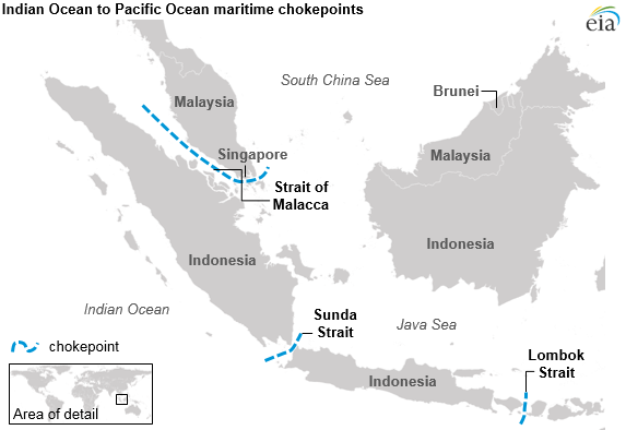
Sunda Strait, located between the Indonesian islands of Sumatra and Java, provides the major sea link between the Indian Ocean and the Java Sea and into East Asian waters. (See Map 25 above.) It is approximately 50 miles long, and at its narrowest point is 13.8 miles wide. Sangian Island separates the 2.4-milewide western channel and the 3.7-mile-wide eastern channel. Sunda’s governing depth is about 100 feet but is not considered suitable for submerged passage given the hydrographic characteristics of its northern exit and the extent of its commercial use.
Lombok Strait is located between the islands of Bali and Lombok. It is the main alternate route for ships travelling between the Indian Ocean and the East Asian Sea. Its navigational width is 11 miles; the length of the passage from the entrance to the Lombok Strait to the exit of the Strait of Malacca is 620 miles. Its depth provides the most suitable alternate route for deep draught vessels to the Malacca and Singapore Straits. The Lombok Strait (Indonesian: Selat Lombok), is a strait connecting the Java Sea to the Indian Ocean, and is located between the islands of Bali and Lombok in Indonesia. The Gili Islands are on the Lombok side.
In 1988, Indonesia reportedly closed these straits for a period of time. The U.S. reaction was described in a letter to a lecturer at the Faculty of Law, University of Sydney, Australia, in part as follows:
The United States was not notified by Indonesia of the closure of the Straits of Lombok and Sunda but, on learning that Indonesia may have ordered its Navy to close those straits for naval exercises and might be conducting naval exercises in a manner that hampered international transit rights, expressed its concern to the appropriate Indonesian governmental officials.
The United States is of the view that interference with the right of straits transit passage or archipelagic sea lanes passage would violate international law as reflected in the 1982 Law of the Sea Convention and the commitments Indonesia made that its practice regarding the archipelagic claim was now fully consistent therewith, on which basis the United States was able in 1986 to be the first maritime nation to recognize Indonesia’s archipelagic claim.
Indonesian archipelagic sea lanes and air routes have not been proposed by Indonesia, acted upon by the competent international organizations or designated by Indonesia in accordance with procedures described in article 53 of the LOS Convention. All normal international passage routes through the archipelago are subject to the regime of archipelagic sea lanes passage in any event. The fundamental rules for archipelagic sea lanes passage and transit passage are the same. No nation may, consistent with international law, prohibit passage of foreign vessels or aircraft or act in a manner that interferes with straits transit or archipelagic sea lanes passage. See articles 44 and 54 of the 1982 Law of the Sea Convention which reflect the customary international law on point.
Applying the objective criteria set forth in Parts III and IV of the LOS Convention, it is clear that Lombok, Sunda and Malacca are unquestionably “straits used for international navigation” and, therefore, are subject to the straits transit regime, while Lombok and Sunda also qualify as “normal passage routes used for international navigation or overflight” and thus are subject to the regime of archipelagic sea lanes passage.
The United States cannot accept either express closure of the straits or conduct that has the effect of denying navigation and overflight rights. While it is perfectly reasonable for an archipelagic state to conduct naval exercises in its straits, it may not carry out those exercises in a way that closes the straits, either expressly or constructively, that creates a threat to the safety of users of the straits, or that hampers the right of navigation and overflight through the straits or archipelagic sea lanes.
Why is the Sunda Strait important?
Presently, the Sunda Strait is the most important link between the Java Sea and the Indian Ocean as it transports warm, low-salinity Java Sea water into the eastern tropical Indian Ocean [Putri, 2005].
How did the Sunda Strait tsunami form?
The cause of the Sunda Strait tsunami was a massive landslide on the southwestern flank of Anak Krakatau, a volcanic island in the Sunda Strait. This failed to trigger the tsunami warning system designed to detect earthquakes capable of producing tsunamis, not underwater landslides.