
The land
Geology
The Arctic lands have developed geologically around four nuclei of ancient crystalline rocks. The largest of these, the Canadian Shield, underlies all the Canadian Arctic except for part of the Queen Elizabeth Islands. It is separated by Baffin Bay from a similar shield area that underlies most of Greenland. The Baltic (or Scandinavian) Shield, centred on Finland, includes all of northern Scandinavia (except the Norwegian coast) and the northwestern corner of Russia. The two other blocks are smaller. The Angaran Shield is exposed between the Khatanga and Lena rivers in north-central Siberia and the Aldan Shield is exposed in eastern Siberia.
In the sectors between the shields, there have been long periods of marine sedimentation, and consequently the shields are partly buried. In some areas thick sediments were subsequently folded, thus producing mountains, many of which have since been destroyed by erosion. Two main orogenies (mountain-building periods) have been recognized in the Arctic. In Paleozoic times (about 542 million to 251 million years ago) there developed a complex mountain system that includes both Caledonian and Hercynian elements. It extends from the Queen Elizabeth Islands through Peary Land and along the east coast of Greenland. Mountain building occurred during the same period in Svalbard, Novaya Zemlya, the northern Urals, the Taymyr Peninsula, and Severnaya Zemlya. There is considerable speculation as to how these mountains are linked beneath the sea. The second orogeny occurred during the Mesozoic (251 million to 65.5 million years ago) and Cenozoic (the past 65.5 million years) eras. These mountains survive in northeastern Siberia and Alaska. Horizontal or lightly warped sedimentary rocks cover part of the shield in northern Canada, where they are preserved in basins and troughs. Sedimentary rocks are even more extensive in northern Russia and in western and central Siberia, where they range in age from early Paleozoic to Quaternary (the past 2.6 million years).
It is evident that the polar landmasses have been transported on lithospheric plates through geologic time and that their positions relative to each other and to the North Pole have changed, with significant modification to ocean circulation and to climate. Motion of plates in the Paleogene and Neogene periods (about 65.5 million to 2.6 million years ago) led to igneous activity in two regions. One was associated with mountain building around the North Pacific, and active volcanoes are still found in Kamchatka, the Aleutian Islands, and Alaska. The other area of igneous activity extended across the North Atlantic and included the whole of Iceland, Jan Mayen Island, and east Greenland south of Scoresby Sound; it was probably connected to west Greenland north of Disko Bay and to east Baffin Island. Volcanism continues in Iceland and on Jan Mayen, and hot springs are found in Greenland.
Continental ice sheets of the past
Little is known about the climate of the northern lands in early Cenozoic times; it is possible that the tree line was at least 1,000 miles farther north than at present. During the Cenozoic, however, the polar lands became cooler and permanent land ice formed, first in the Alaskan mountain ranges and subsequently, by the end of the Pliocene (2.6 million years ago), in Greenland. By the onset of the Quaternary Period, glaciers were widespread in northern latitudes. Throughout the Quaternary, continental-scale ice sheets expanded and decayed on at least eight occasions in response to major climatic oscillations in high latitudes. Detailed information available for the final glaciation (80,000 to 10,000 years ago) indicates that in North America the main ice sheet developed on Baffin Island and swept south and west across Canada, amalgamating with smaller glaciers to form the Laurentide Ice Sheet, covering much of the continent between the Atlantic Ocean and the Rocky Mountains and between the Arctic Ocean and the Ohio and Missouri river valleys. A smaller ice cap formed in the Western Cordillera. The northern margin of the ice lay along the Brooks Range (excluding the Yukon Basin) and across the southern islands of the Canadian Archipelago. To the north the Queen Elizabeth Islands supported small, probably thin, ice caps. Glacier ice from Greenland crossed Nares Strait to reach Ellesmere Island during maximum glaciation.
The Atlantic Arctic islands were covered with ice except where isolated mountain peaks (nunataks) projected through the ice. In Europe the Scandinavian Ice Sheet covered most of northern Europe between Severnaya Zemlya in Russia and the British Isles. Northeastern Siberia escaped heavy glaciation, although, as in northern Canada, the ice sheet had been more extensive in an earlier glaciation.
As the ice sheets melted, unique landforms developed by the ice were revealed. Although not restricted to the present Arctic, they are often prominent there and, in the absence of forests, are clearly visible. In areas of crystalline rocks, including large parts of the northern Canadian Shield and Finland, the ice left disarranged drainage and innumerable lakes. In the lowlands deep glacial deposits filled eroded surfaces and produced a smoother landscape, often broken by low ridges and hills of glacial material, drumlins, rogen (ribbed) moraines, and eskers. In the uplands the characteristic glacial landforms are U-shaped valleys. Near the polar coasts these have been submerged to produce fjords, which are well developed in southern Alaska, along the east coast of Canada, around Greenland, in east and west Iceland, along the coast of Norway, and on many of the Arctic islands.
Because of their enormous weight, continental ice sheets depress the Earth’s crust. As the ice sheets melted at the close of the Pleistocene Epoch (11,700 years ago), the land slowly recovered its former altitude, but before this was completed the sea flooded the coastal areas. Subsequent emergence has elevated marine beaches and sediments to considerable heights in many parts of the Arctic, where their origin is easily recognized from the presence of marine shells, the skeletons of sea mammals, and driftwood. The highest strandlines are found 500 to 900 feet above contemporary sea level in many parts of the western and central Canadian Arctic and somewhat lower along the Baffin Bay and Labrador coasts. Comparable emergence is found on Svalbard, Greenland, the northern Urals, and on the Franz Josef Archipelago, where it reaches more than 1,500 feet. In many emerged lowlands, such as those south and west of Hudson Bay, the raised beaches are the most conspicuous features in the landscape, forming hundreds of low, dry, gravel ridges in the otherwise ill-drained plains. Emergence is still continuing, and in parts of northern Canada and northern Sweden uplift of two to three feet a century has occurred during the historical period. In contrast, a few Arctic coasts, notably around the Beaufort Sea, are experiencing submergence at the present time.
Polar continental shelves in areas that escaped glaciation during the ice ages were exposed during periods of low sea level, especially in the Bering Strait and Sea (Beringia), which facilitated migration of people to North America from Asia, and in the Laptev and East Siberian seas.
What are the differences between the Arctic and Antarctica?
The primary difference between the Arctic and Antarctica is geographical. The Arctic is an ocean, covered by a thin layer of perennial sea ice and surrounded by land. … Antarctica, on the other hand, is a continent, covered by a very thick ice cap and surrounded by a rim of sea ice and the Southern Ocean.
Which is bigger the Arctic or Antarctica?
The Arctic region includes the Arctic Ocean, parts of Greenland, Alaska, Canada, Norway and Russia, and covers about 5.5 million square miles. The Antarctic covers nearly the same area, 5.4 million square miles. … The Arctic Ocean accounts for more than five million square miles of the Arctic region.
What are the countries in the Arctic?
The Arctic region covers parts of eight countries: Canada, Greenland, Iceland, Norway, Sweden, Finland, Russia, and the United States.
What is the symbol of the Arctic?
The Polar BearThe Polar Bear as National Symbol and Emblem of Conservation. Polar bears are prized for very different reasons across cultures, as Michael Engelhard explains in this excerpt from his new book, “Ice Bear: The Cultural History of an Arctic Icon.”
What is Arctic habitat?
The Arctic habitat is a very cold place at the top of the world where some plants and animals live and that is made up of the Arctic Ocean, icy glaciers, and tundra, or flat plains with no trees.
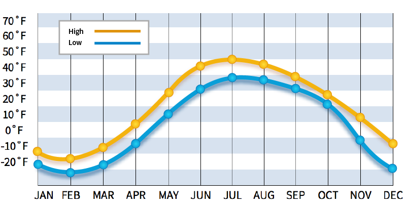
What are the temperatures in the Arctic?
Does the North Pole have rain?
North Pole gets some kind of precipitation, on average, 90 days per year. Precipitation is rain, snow, sleet, or hail that falls to the ground. In order for precipitation to be counted you have to get at least . 01 inches on the ground to measure.