Background
Australia and Indonesia have settled their boundary delimitation stage by
stage. In 1971 the two countries delimited their continental shelf boundaries
in part of the Arafura Sea (Point A1-Point A12). Subsequently in 1972,
the two countries agreed on the boundary of the remaining part of the continental
shelf in the Arafura Sea (Point A13-Point A16) and in the offshore
areas of West Timor (Point A17-Point A25). However, the area off East
Timor, which was then a colony of Portugal, was left undelimited and was
called the “Timor Gap”. After East Timor was annexed by Indonesia in
1975, various rounds of negotiation have been held for delimitation in the
area of the Timor Gap. Australia argued in favour of, and Indonesia argued
against, the principle of natural prolongation for the purpose of the delimitation
in this area. In 1985 when the ICJ adopted the distance criterion as
the basis of title to the continental shelf in the Libya/Malta Continental
Shelf Case, Australia’s position was weakened.
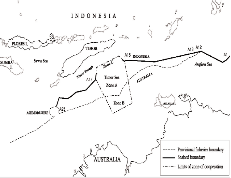
Method of Shaping the Joint Development Zone
In shaping the zone of co-operation, the Australian position for a natural
prolongation line along the Timor Trough and the Indonesian position for
a median line were both accommodated. The zone is divided into three
areas; Area C, Area A and Area B from north to south. The northern limit
of the zone is drawn along the bathymetric axis of the Timor Trough and
its southern boundary is drawn along the 200 N.M. line from the Island of
Timor. The median line is adopted to divide Area A and Area B in the zone.
Area A and Area C is divided by a modified line of 1,500 metres isobath.
Forms and Provisions
The provisional arrangement was signed in December 1989 in the form of
a formal Treaty. It is entitled “Treaty on the Zone of Co-operation in an
Area between the Indonesian Province of East Timor and Northern Australia”.
The treaty provides that, “Nothing contained in this Treaty and no acts or
activities taking place while this Treaty is in force, shall be interpreted as
prejudicing the position of either Contracting States on a permanent continental
shelf delimitation in the Zone of Co-operation nor shall anything
contained in it be considered as affecting the respective sovereign rights
claimed by each Contracting State in the Zone of Co-operation”.
The treaty also stipulates that “the Contracting States shall continue
their efforts to reach agreement on a permanent continental shelf delimitation
in the Zone of Co-operation”. This treaty is valid for a period of 40
years, after which it will continue to be valid for successive terms of 20
years unless the two States agree on a permanent boundary by the end of
each term, including the initial term of 40 years. As East Timor voted for
independence from Indonesia in 1999, East Timor and Australia began to
negotiate a joint development regime in the Timor Gap and are close to
agreeing on the basic tenets of a new treaty.
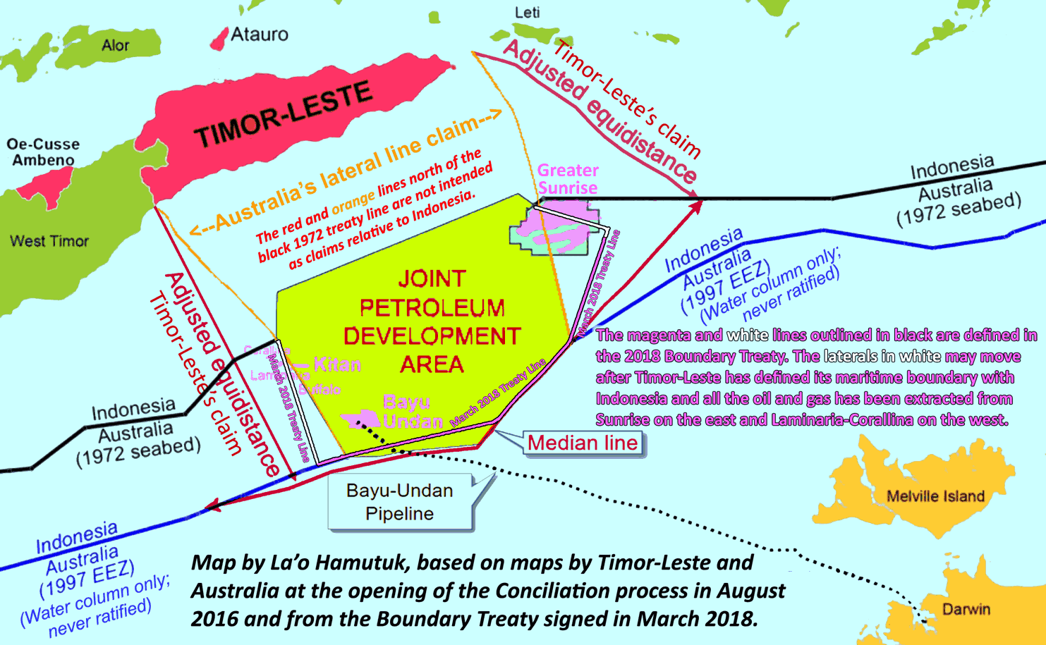
Operational Mechanism and the Effectiveness of the Arrangement
In Area A, which measures 9,375 square N.M. in area, exploitation and
exploration are to be supervised and controlled by a ministerial council and
a joint authority. In Area B, which measures 5,178 square N.M. in area, an
Australian offshore regime is to be applied. In Area C, which covers 1,576
square N.M. in area, an Indonesian legal regime is to be applied. Even if
Area C and B are under the jurisdiction of Indonesia and Australia respectively,
each country is to pay the other country certain tax revenues derived
from exploitation taking place in those areas. On 14 March 1997 the two
countries signed the Treaty Establishing an Exclusive Economic Zone
Boundary and Certain Seabed Boundary. However, the 1997 Treaty does
not affect the legal regime of the Treaty in the Zone of Co-operation.