ARTICLE 121 OF THE 1982 CONVENTION ON THE LAW OF THE SEA
Article 121 of the 1982 Convention deals with the regime of islands.
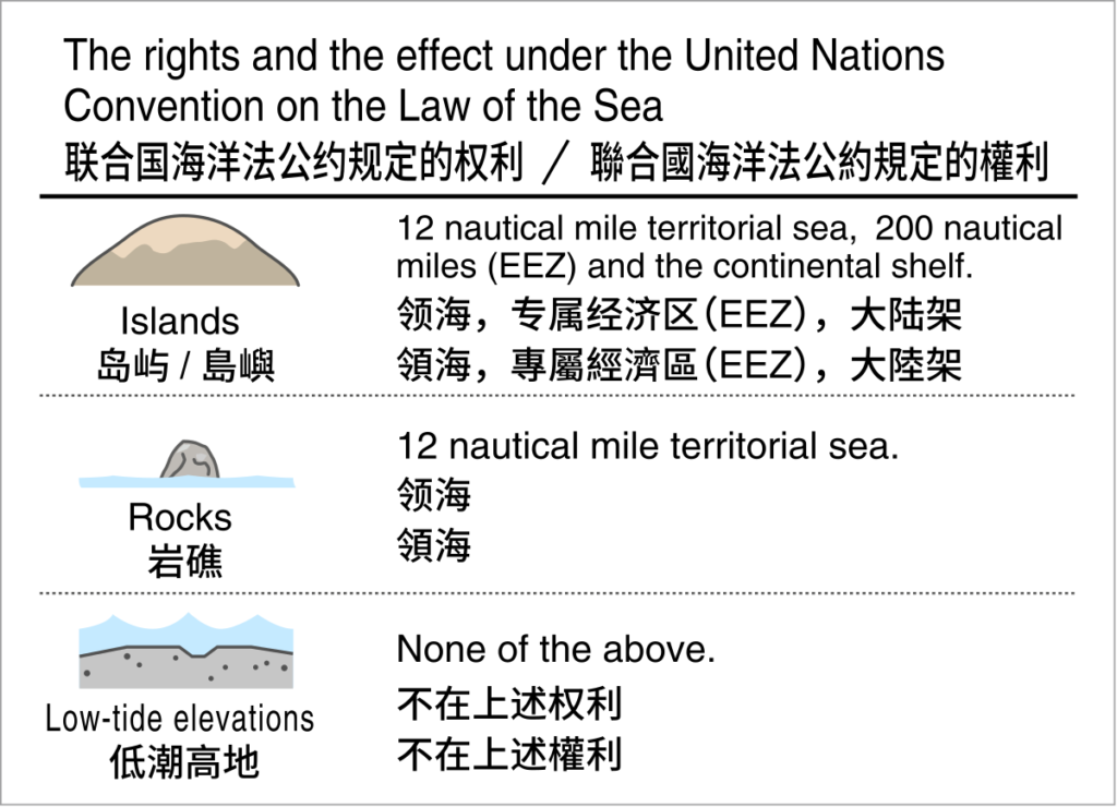
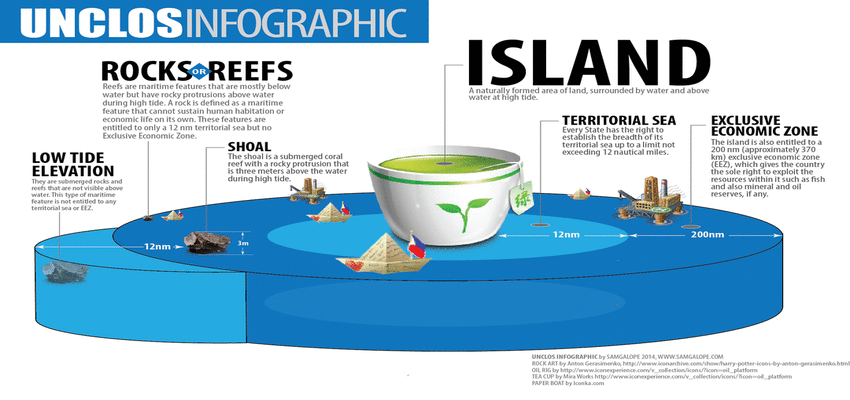
- An island is a naturally formed area of land, surrounded by water, which is above water at high tide.
- Except as provided for in paragraph 3, the territorial sea, the contiguous zone, the exclusive economic zone and the continental shelf of an island are determined in accordance with the provisions of this Convention applicable to other land territory.
- Rocks which cannot sustain human habitation or economic life of their own shall have no exclusive economic zone or continental shelf.
WHAT CONSTITUTES AN ISLAND
The first two paragraphs of Article 121 of UNCLOS have not caused any significant disagreement between academic commentators. Paragraph 1 of Article 121 of UNCLOS represents a direct repetition of Article 10, paragraph 1 of the 1958 Convention on the Territorial Sea and Contiguous Zone. Four requirements are identified by these Articles which a feature must fulfill if it is to legally qualify as an island. These criteria are that an island must be ‘naturally formed’, be an ‘area of land’, be ‘surrounded by water’ and, critically, must be ‘above water at high tide.’ The first requirement, that an island be ‘naturally formed’ serves to disqualify artificial “islands” such as platforms constructed on submerged shoals, lowtide elevations or reefs. Such artificial islands are not considered to be legal islands as is made explicit by Article 60, paragraph 8 of UNCLOS:
Artificial islands, installations and structures do not posses the status of islands. They have no territorial sea of their own, and their presence does not affect the delimitation of the territorial sea, the exclusive economic zone or the continental shelf. Nevertheless, several states have sought to protect certain insular features which, although naturally formed, are unstable and susceptible to erosion and in danger of losing their status as islands through falling below the ‘above water at high tide’ criterion.
Perhaps the most striking example of efforts to preserve the insular character of vulnerable formations is Japan’s maintenance of its southernmost islet of Okintorishima above high tide. This feature generates approximately 160,000 sq.nm of exclusive economic zone for Japan despite consisting merely of two small peaks sitting atop an otherwise submerged reef. One of these peaks is no more than three feet above high-tide. The Japanese authorities have built artificial sea defences surrounding the islet. Although these artificial structures are higher than the natural formations themselves, it is the latter which generate an extended maritime zone.
Nunn (1994), has characterised cays as being impermanent accumulations of sand and shingle which, with the accumulation of beach rock, may develop into more stable features termed motu. This gives the impression that cays may be subject to evolution and decay over time. It is, however, reasonable to assume that on those cays which are occupied measures have been taken by the occupants to prevent erosion and there may even have been attempts to promote island-building. As a result such features may well qualify as ‘rocks’ or even ‘islands’ (Hancox and Prescott, 1995).
The ‘surrounded by water’ requirement is an uncontroversial rule.
Attention has been drawn to one possible uncertainty which is the unqualified reference to high tide in paragraph one of Article 121. The question of an island being ‘above water at high-tide’ is fundamental as the preceding sections relating to the other requirements of Article 121 (1) demonstrate. A feature’s relationship to the tidal level distinguishes between islands (above high-tide), low-tide elevations (above low-tide but submerged at high-tide) and non-insular features (submerged at low-tide). This uncertainty relates to the choice of vertical tidal datum used to determine what represents the high and low tidal levels. No universally accepted vertical tidal datum is in use.
Just as there are a number of low-tides there are an equivalent number of high tides. Maling (1989: 239-41) identifies five high tides within any single 19 year lunar cycle; they are mean high water neaps, mean high water, mean higher high water, mean high water spring tides and highest astronomical tide. He also notes the highest observed high water which would be associated with abnormal meteorological conditions such as a storm surge. The absence of a specific high tide poses the question of whether an island can ever be covered by the sea. Symmons notes that the preparatory documents for the deliberations that produced the 1958 Convention on the Territorial Sea and Contiguous Zone contained a definition which included the phrase ‘. . . an area of land, surrounded by water, which in normal circumstances is permanently above high water’. It was included reluctantly because some delegates thought the concept of normal circumstances was implied. This proposal was discarded in favour of the sentence that was also used in the first paragraph of Article 121. It was discarded at the urging of the United States delegates for the following reasons. The requirements of the I.L.C.’s definition of an island that it shall be above the high-water mark “in normal circumstances” and “permanently” are conflicting, and since there is no established state practice regarding the effect of subnormal or abnormal or seasonal tidal action on the status of islands, these terms should be omitted.
While Symmons accepts the commonsense of allowing features to be classed as islands even though they are over-topped by exceptional or freak tides he appears to have concerns about states that have adopted particular tidal levels other than the highest spring tides.
On the other hand, it does not seem right that a feature should have insular status merely because it is submerged only at highest spring tides, but is generally above the surface at neap tides.
He then shows that the United Kingdom and New Zealand have adopted the mean high water spring tide and relates this to the Franco-British Arbitration case in the Western Approaches when the status of the Eddystone Rocks was a consideration. Alas, the Court decided that the status of Eddystone Rocks was not relevant to the determination of basepoints There can be no question that the understanding of those who negotiated the definition considered that the submergence of an island should be an unusual event. However, the decisive American intervention included reference to seasonal tidal action as well as tidal action that was subnormal or abnormal.
Beazley (1987, 8) assumes the term ‘high tide’ must refer to the high-tide line marked as the coastline on charts officially recognised by the country concerned. This seems sensible since the reference in Article 5 of the 1982 Convention, to the normal baseline refers to it being ‘. . . the low-water line along the coast as marked on large scale charts officially recognised by the coastal state’. Beazley’s suggestion would not preclude the sea flooding over an island in exceptional circumstances.
An example of this situation has been reported by Grant Boyes. Sometimes waves break across the cay called Theva-I-Ra in the South Pacific which has a height of 1.8 metres and length about 1,000 metres according to the British Pilot (The Hydrographer, 1984: 133).
In 1984 the cay was reported to have vegetation but in 1969 it was reported to be bare leading the author of the 1984 Pilot to speculate that the vegetation might not be able to survive tropical storms. Nevertheless, it was used as a basepoint by Fiji and France when they agreed on a maritime boundary separating the exclusive economic zone between Fiji and New Caledonia.