the list of geographical coordinates of points, using the geodetic system ITRF-96, which are specified in the Agreement between the Socialist Republic of Viet Nam and the People’s Republic of China on the Delimitation of the Territorial Sea, the Exclusive Economic Zone and Continental Shelf in the Gulf of Tonkin, which was signed by the two countries on 25 December 2000, and took officially effect on 30 June 2004.
Legal basis for maritime claims of Vietnam
Declaration of the Government of the R.S. of Vietnam on the Territorial Sea, the Contiguous Zone, the Exclusive Economic Zone and the Continental Shelf of 12 May 1977
Declaration of the Government of the R.S. of Vietnam on the baselines from which the breadth of the territorial sea is measured of 12 November 1982
National Assembly’s Resolution of the ratification of the 1982 UNCLOS of 23 June 1994
Results of the resolution of the delimitation of maritime overlapping areas with neighboring countries
Vietnam – Cambodia agreement on historic waters:
- Vietnam and its neighbor Cambodia has adjacent sea areas. Two countries
used to have historic dispute regarding their sovereignty and claims over
some coastal islands and regarding the overlapped territorial seas, exclusive
economic zones and continental shelf, which remain to be resolved. - The two countries sign an agreement on 7 July 1982 placing an area of
over 8000 km2 in the maritime overlapping between the two countries in the
Gulf of Thailand under the status of historic internal waters. - Under this agreement, the two countries agreed to use the Brévie Line, a
line adopted by Governor Brevie in 1939 as the dividing line of sovereignty
over islands between the two countries. In other words, by this agreement,
the dispute over sovereignty of islands between the two countries have
been settled. - It was also agreed that the two countries would determine their maritime
overlapping area at a suitable time.
B. With Thailand
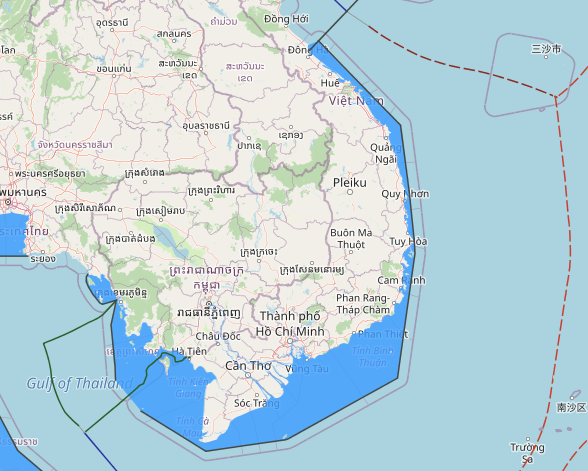
A- Delimitation of Vietnam and Thailand marine area in the Gulf of Thailand:
the overlapping area totaling 6074 km2 in the Gulf of Thailand is resulted from respective claims of Vietnam and Thailand. The two countries officially entered into negotiations in 1992 to determine the area. Agreement was reached after 9 rounds held in 7 years, which grants Vietnam with 32.5% of the area. The agreement was officially signed on 9 August 1997 and came into force on 27 February 1998.
The maritime agreement with Thailand is the first of such agreement Vietnam concluded with neighboring countries in
settling their maritime boundaries. It also constitutes the first pact regarding the Gulf of Thailand and in South East Asia since the coming into force of 1982 UNCLOS. Accordingly, the boundary is the straight line from defined point K to point C. The line also constitutes the single boundary of the overlapped continental shelf and of the EEZ between Thailand and Vietnam.
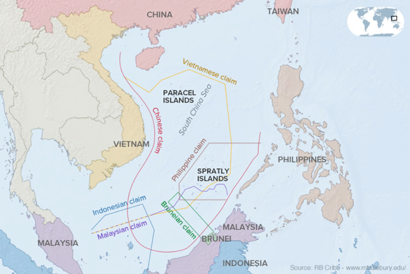
C. With China
1. Geographical description:
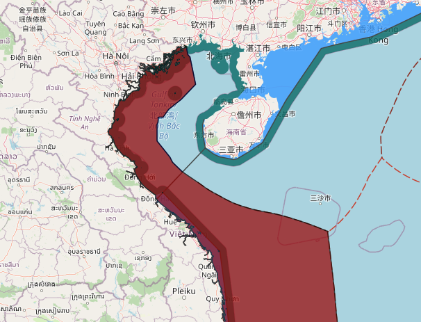
The Tonkin Gulf is one of the world’s largest gulfs with the total area of 126,250 square kilometers (36,000 square nautical miles). Its width, at the maximum, is around 310 kilometers (176 nautical miles) and the narrowest breadth, at its mouth, is around 207.4 kilometers (112 nautical miles).
The Tonkin Gulf are engulfed by 10 provinces and cities of Viet Nam with the total length of 763 kilometers and 2 provinces of China namely Guangxi and Hainan, with the total length of 695 kilometers. The Gulf consists of two mouths, one on the Northwest, namely Qiong Zhou strait, and one on the South which is the main entrance extending 207.4 kilometers in width (112 nautical miles) from Con Co island (of Viet Nam) to Hainan island (of China).
The Gulf on the Vietnamese side contains 2300 islands and coastal rocks, noticeably Bach Long Vi island, which is 110 km away from Viet Nam’s mainland and 130 kilometers away from Hainan island of China. China possesses a few small islands in the Northeast of the Gulf including Wei Zhou and Xie Yang.
- Process of negotiations led to the Agreement:
The process of negotiations on delimitation of the Tonkin Gulf between Viet Nam and China started in 1974 and lasted for 27 years with three stages: the first one, 1974; the second one: 1977-1978 and the last stage: 1992-2000 periods. The first and second stages though were held at governmental level in 1974 (August 1974-November 1974) and in the 1977-1978 period (October 1977-June 1978) did not produce any outcome due to discrepancies in the position of the two countries. It was the fact that, from 1978 to 1991, the political situation between Vietnam and China was not suitable for negotiation on this pending issues.
In 1991, after the normalization of bilateral relations, Viet Nam and China agreed to conduct negotiations to settle all pending border and territorial issues including the delimitation of the Tonkin Gulf. Within nine years period from 1992 to 2000, Vietnam and China held seven rounds of negotiation at governmental level, three meetings between the Heads of governmental-level negotiating teams, 18 rounds of negotiation at working level and many other meetings of the Joint Working Team and Mapping Team (there are 49 meetings in total, and, on average, five meetings each year).
On 25th December 2000, the Agreement on Delimitation of the Tonkin Gulf was signed by the Foreign Ministers of Viet Nam and China in Beijing, marking the successful conclusion of process of negotiations between the two countries on this issue and this Agreement came into force on 30 June 2004.
- Guiding principles applied in the process of negotiations:
In 1992, at the 2nd Governmental-level negotiations on Vietnam-China border and territorial issues, Vietnam and China signed the MOU on the guiding principles applied to the resolution of all border and territorial issues in which, with regard to the delimitation of the Tonkin Gulf, Vietnam and China agreed:
– to apply International Law of the Sea and practice;
– in order to achieve a fair and equitable solution for the delimitation of Tonkin Gulf, Vietnam and China will uphold the equitable principle and take into consideration all relevant circumstances in the Tonkin Gulf.
– to form a Joint Working Team whose tasks were to discuss on the methodology, legal basis, relevant circumstances, area and scope of delimitation to work out a delimited line submitting to the both countries for consideration and approval.
- Main contents of the Agreement:
The conclusion of the Agreement on the Delimitation of the Tonkin Gulf was the result of enduring negotiations which reflected the endeavors and goodwill of both Viet Nam and China. In the process of negotiations, the two parties not only paid due attention to meeting their respective interests but also based its delimitation on international law, especially the 1982 UNCLOS as well as taking into account the specific circumstances of the Gulf.
The Agreement on the Delimitation of the Tonkin Gulf is the second of the three agreements Viet Nam has signed with its neighboring countries (with Thailand in 1997 and Indonesia in 2003), but is the first, most comprehensive of its kind. The Agreement clearly delimits the territorial waters, the exclusive economic zones and continental shelves between Viet Nam and China in the Gulf.
The two parties agreed on a delimited line comprising 21 points, from the Bei Lun river mouth to the Southern mouth of the Gulf. The line connecting point 1 to point 9 is the boundary of the territorial waters, and point 9 to point 21 is the delimitation line of the exclusive economic zones and continental shelves. According to the Agreement, Viet Nam is entitled to 53.23% of the Gulf’s total area and China 46.77%.
On the Vietnamese side, two islands were given partial effects in delimitation, namely Bach Long Vi island which was located in the center of the Tonkin Gulf (about 110 km off the coast of Viet Nam and some 130 kilometers off the coast of Hainan-China (25% effect) and Con Co island (50% effect) which was 13 nautical miles from Vietnamese shore.
In the Agreement, the two parties pledge to respect each other’s sovereignty, sovereign rights and jurisdiction over their respective territorial water, exclusive economic zone and continental shelf in the Tonkin Gulf. Accordingly, each party can independently carry out exploration and exploitation of mineral resources on their respective continental shelf. As for single oil, natural gas reservoirs or other mineral reserves overlying the line of delimitation, the two parties will conduct friendly consultations to reach agreement on the most effective way of exploitation and on the equitable sharing of benefits from the exploitation. In addition, the Agreement embodies provisions on the rational utilization and sustainable development of living resources in the Tonkin Gulf, and on the cooperation between the two countries in the preservation, management and utilization of living resources in their exclusive economic zones.
D. With Indonesia
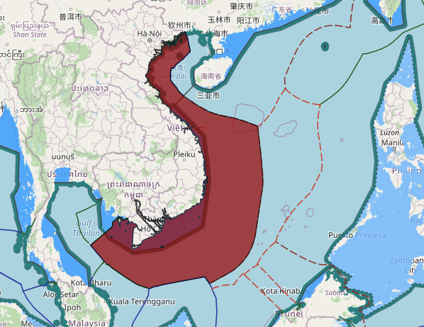
– Determination of Vietnam -Indonesia overlapped continental shelf
The overlap was created by South Vietnam’s 1971 claim and Indonesia’s 1968 claim. The area totals almost 37,000 km2 to the South-East of China Sea. Rounds of negotiations were initiated in 1972, yet rendered any settlement.
After national re-unification, Vietnam officially opened the floor for negotiations. During the process, two sides gradually merged their differences and figured out an appropriate and reasonable settlement to their overlapping claims.
By 26 June 2003, an agreement on continental shelf delimitation was signed. Entering into force on 29 May 2007, it identifies a boundary line which is a defined dotted line. The two countries agreed to enter into negotiations on a settlement of their EEZ in the near future.
Joint development agreement
1-With Malaysia
– Joint exploitation arrangement between Vietnam and Malaysia
There is an overlap of 2800 km2 in the Gulf of Thailand created by the claims of South Vietnam government in 1971 and Malaysia in 1979, respectively.
Based on their leaders’ agreement, Vietnam and Malaysia carried out negotiations in 1992 on settling the overlap. In the first round the two sides arranged to apply a joint development model in a partial area. According to the 5 June 1992 arrangement, two sides nominated their national petroleum company, namely Petrovietnam and Petronas
respectively, to hold talks on a commercial arrangement on joint exploitation of petroleum resources in the area in the principle of equality in rights and obligations. On 29 July 1997 the first barrel was extracted on a commercial basis. Joint development activities in the area are being carried out successfully contributing to enhanced
economic development as well as their bilateral relations.
Besides, there is an overlap of 875km2 created by Vietnam’s 1971 claims, Thailand’s 1973 claims and Malaysia’s 1979 claims. Negotiations were undertaken in 1997 to define the overlapping area. Three sides agreed on the principle of joint development in the area. They have now come to technical discussion regarding details of a joint development arrangement.
Fishing cooperation between Vietnam and China in the Tonkin Gulf
During the process of negotiations on the delimitation of the Tonkin Gulf, the question of fishing cooperation between had been proposed by the Chinese side on the account that in the 1950s and 1960s, Viet Nam and China had signed a number of agreements on fishing cooperation in the Tonkin Gulf (the 1957 Agreement on Sailboat Fishing, the 1961 Protocol to the 1957 Agreement on Sailboat Fishing, the 1963 Agreement on Fishing Cooperation in the Tonkin Gulf).
After careful consideration of the provisions of the 1982 Convention on the cooperation among states concerned in the exclusive economic zone and the closed and semi-closed water areas, the exploration and exploitation of the Tonkin Gulf and the natural conditions of the fishery resources, with the aim of meeting the legitimate interests of fishermen of both countries, Viet Nam and China agreed to start negotiations to conclude an Agreement on Fishing Cooperation in parallel with the negotiations on the Agreement on the Delimitation of the Tonkin Gulf.
On 25 December 2000, the Agreement on Fishing Cooperation in the Tonkin Gulf was signed together with the Agreement on the Delimitation of the Tonkin Gulf in which Vietnam and China agreed on fishing cooperation in certain defined areas inside the Tonkin Gulf with concrete time limits.