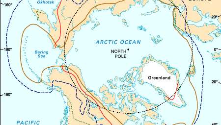
in britanica we read, Although the detail of the terrain in many parts of the Arctic is directly attributable to the Pleistocene glaciations, the major physiographic divisions reveal close correlation with geologic structure. The two largest shield areas, the Canadian and the Baltic, have developed similar landscapes. West of Hudson Bay, in southwestern Baffin Island, and in Karelia the land is low and rocky with countless lakes and disjointed drainage. Uplands, generally 1,000 to 2,000 feet above sea level and partially covered with glacial deposits, are more widely distributed. They form the interior of Quebec-Labrador and parts of the Northwest Territories in Canada, and the Lapland Plateau in northern Scandinavia. The eastern rim of the Canadian Shield in Canada from Labrador to Ellesmere Island has been raised by crustal changes and then dissected by glaciers to produce fjords that separate mountain peaks more than 6,000 feet high. The surface of the shield in Greenland has the shape of an elongated basin, with the central part, which is below sea level, buried beneath the Greenland ice cap. Around the margins, on the east and west coasts, the mountainous rim is penetrated by deep troughs through which local and inland-ice glaciers flow to the sea. The mountains are highest in the east, where they exceed 10,000 feet.
In shield areas where sedimentary rocks mantle the crystalline variety, as in north-central Siberia, the southern sector of the Canadian archipelago, and Peary Land, the topography varies from plains to plateaus, with the latter deeply dissected by narrow valleys. Far beyond the margins of the shields, extensive plains have evolved on soft sedimentary rocks. In North America these form the Mackenzie Lowlands, Banks and Prince Patrick islands, and the Arctic Plains section of northern Alaska; in northern Europe they form the Severnaya Dvina and Pechora Plains. In Siberia the Ob delta, its northeastern extension to the Laptev Sea, the North Siberian Lowland, the West Siberian Plain, and farther east the Lena-Kolyma plains (including the New Siberian Islands) have also developed on sedimentary rocks. Although there are differences in degree, these terrains are essentially flat, occasionally broken by low rock scarps, and covered with numerous shallow lakes. The plains are crossed by large rivers that have laid down deep alluvial deposits.
The strongly folded rocks associated with the two orogenic periods in the Arctic form separate physiographic regions. The original mountains of the older, Paleozoic folding were long ago destroyed by erosion, but the rocks have been elevated in recent geologic time, and renewed erosion, often by ice, has produced a landscape of plateaus, hills, and mountains very similar to the higher parts of the shields. In Ellesmere Island the mountains are nearly 10,000 feet high. In Peary Land and Spitsbergen maximum elevations are about 6,000 feet, while in eastern Svalbard and on Novaya Zemlya and Severnaya Zemlya the uplands rarely exceed 2,000 feet. The younger groups of fold mountains of northeast Siberia and Alaska are generally higher. Peaks of 10,000 feet are found in the Chersky Mountains, 15,000 feet in Kamchatka, and even higher in southern Alaska. Characteristic of this physiographic division are wide intermontane basins drained by large rivers, including the Yukon and Kolyma.
Throughout the Arctic, excluding a few maritime areas, the winter cold is so intense that the ground remains permanently frozen except for a shallow upper zone, called the active layer, which thaws during the brief summer. Permanently frozen ground (permafrost) covers nearly one-quarter of the Earth’s surface. In northern Alaska and Canada scattered observations suggest that permafrost is 800 to 1,500 feet deep; it is generally deeper in northern Siberia. The deepest known permafrost is in northern Siberia, where it exceeds 2,000 feet. The depth of the permafrost depends on the site, climate, vegetation, and recent history of the area, particularly whether it was covered by sea or glacier ice. Very deep permafrost was probably formed in unglaciated areas during the extreme cold of the ice ages. To the south in the subarctic, the permafrost thins and eventually becomes discontinuous, although locally it may still be 200 to 400 feet thick; along its southern boundary, permafrost survives under peat and in muskeg. In areas of continuous permafrost the active layer may be many feet thick in sandy well-drained soils with little vegetation but is usually less than six inches thick beneath peat.
Permafrost occurs in both bedrock and surface deposits. It has little effect in most rocks, but in fine-grained, unconsolidated sediments, particularly silts, lenses of ice, called ground ice, grow by migration of moisture, and in extreme cases half the volume of Arctic silts may be ice. Ground ice is often exposed in riverbanks and sea cliffs, where it may be 20 to 30 feet thick. In northern Siberia fossil ice has been reported up to 200 feet thick, although it may be glacier or lake ice that has subsequently been buried under river deposits. If ground ice melts, owing to a change in climate, hollows develop on the surface and quickly fill with water to form lakes and ponds. When frozen the silts have considerable strength, but if they thaw they change in volume, lose their strength, and may turn to mud. Variations in volume and bearing capacity of the ground due to changes in the permafrost constitute one of the major problems in Arctic construction.