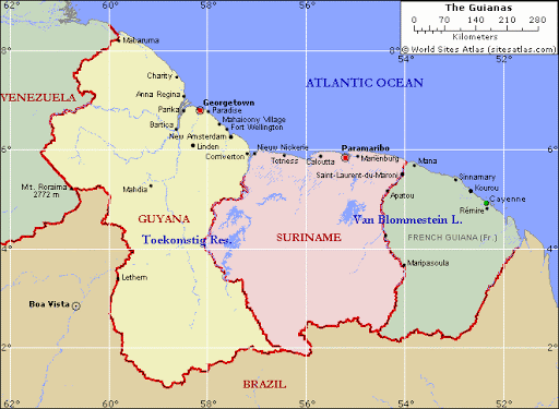
The Court of Arbitration was requested to delimitate both the land
border and the maritime boundary of the homogeneous continental shelf
of the two federate states. The case involved the analysis of complex
historical facts and conduct of the parties. With respect to the land
boundary in particular, delimitation was necessary to allocate the
formerly nomadic, borderless territory for the purpose of oil extraction.
While the land boundary is not of interest in the present context, the
arguments and decisions with regard to the maritime boundary are an
important contribution to the emerging case law on our subject.
Category: Arbitration
Arbitration, a form of alternative dispute resolution, is a way to resolve disputes outside the judiciary courts. The dispute will be decided by one or more persons, which renders the ‘arbitration award’.
The 1977/78 Anglo-French Channel arbitration
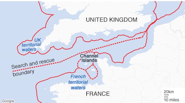
The delimitation of the continental shelf in the English Channel and its
western approaches in the Atlantic area posed problems during negotiations
preceding this landmark arbitration for two reasons. Firstly, the
English Channel Islands, under British sovereignty for purposes of foreign
relations, consist of an archipelagic formation of four main groups
with the principle islands of Alderney, Guernsey, Jersey, Sark, Herm and
Jethon. The islands are situated off the coast of France, the closest, the
island of Ecrehos, being only 6.6 miles from the continent. Geologically,
the islands are both linked to the English mainland by a basic continuity
of the shelf, and also separated from it by a the trough of Hurd Deep, a
trench of some 100 metres running a few miles north of the islands in
south-westerly direction for some 80 miles. Secondly, in the western part
(or the western approaches or Atlantic area), both states show atypical
coastal configurations in the sense that they are neither in a clearly
opposite nor in a clearly adjacent constellation. Moreover, both parties
have islands: the Scilly Isles off the Cornish coast and the island of Ushant
(Quessant) off the Brest peninsula. As possible base points, both groups
of islands could strongly influence the direction of the western boundary
extending into the Atlantic Ocean.
Maritime boundaries between Norway and Sweden
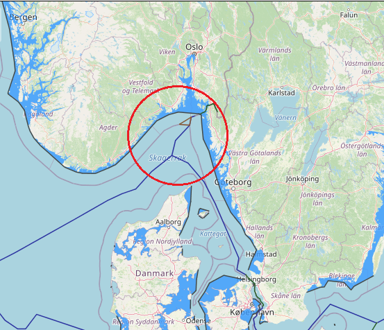
The territorial sea boundary between Norway and Sweden also has a long history having been delimited through an arbitral award of 23 October 1909 following earlier agreements in 1661, 1897 and 1904. By virtue of a compromise signed on March 14, 1908, Norway and Sweden decided to submit to arbitration the question of the maritime boundary between the two countries, insofar as it was not settled by the Resolution royal of March 15, 1904 . The Tribunal constituted for the purposes of this arbitration was called upon to decide whether the frontier line had been fixed either entirely or in part by the Treaty of 1661, and if not, to fix this line taking into account the circumstances of fact and principles of international law. It was composed as follows: Mr. JA Loeff, from the Netherlands; MFVN Beichmann, from Norway, and MK Hj. L. Hammarskjôld, from Sweden. Alone, the latter was a member of the Permanent Court of Arbitration in The Hague. The Tribunal sat from August 28 to October 18, 1909, and meanwhile visited the disputed area. He rendered his award dated October 23, 1909. By this award, the Tribunal determined the maritime boundary between Norway and Sweden, in application of the principles in force in the two countries at the time of the conclusion of the original delimitation treaty. and in view of several long-standing factual circumstances. Settlement of the question of the maritime boundary between Norway and Sweden – Competence of the Tribunal determined by the interpretation of the Compromis – Maritime territory as essential appurtenance of land territory a fundamental principle of International Law – Median line – Thalweg – Historic title. Sweden established an EEZ in 1993 which in the North Sea follows the previously agreed continental shelf boundary with Norway.
View More Maritime boundaries between Norway and SwedenThe Grisbådarna Case
The Grisbådarna Case, Norway v Sweden, Award, (1909) XI RIAA 155, (1910) XVII RGDIP 177, ICGJ 404 (PCA 1909), 23rd October 1909, Permanent Court of Arbitration [PCA]; Ad Hoc – Geneva, Grisbådarna Case, Norway v Sweden, Permanent Court of Arbitration
View More The Grisbådarna CaseThe North Atlantic Coast Fisheries Case (Great Britain / United States of America), fact and decision
The North Atlantic Coast Fisheries Case (Great Britain / United States of America), fact and decision, Great Britain / United States of America, North Atlantic Coast Fisheries case, tribunal
View More The North Atlantic Coast Fisheries Case (Great Britain / United States of America), fact and decisionGuyana v. Suriname case about maritime boundary
Guyana v. Suriname case about maritime boundary, Guyana, maritime boundary, Suriname
View More Guyana v. Suriname case about maritime boundary


