Impacts of Global Warming on Marine Boundaries: An Analytical Overview
View More Impacts of Global Warming on Marine Boundaries: An Analytical OverviewCategory: maritime delimitation claim
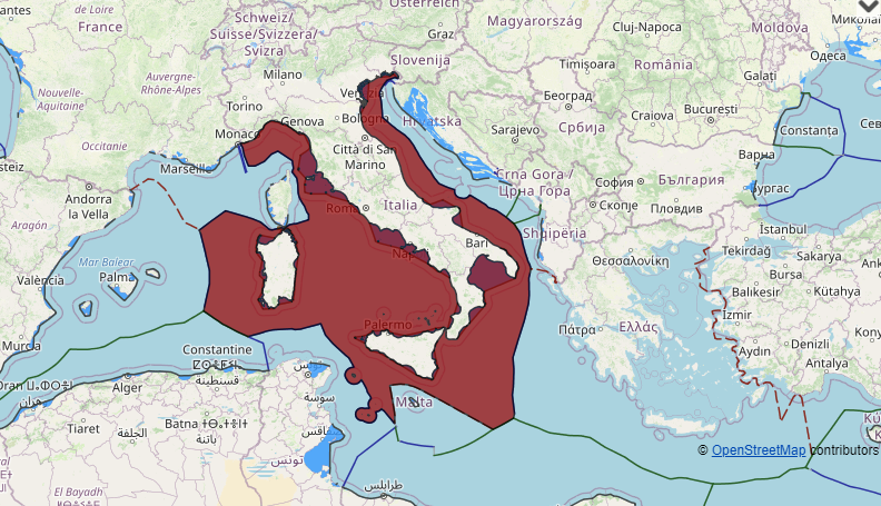
Italy maritime claims about baselines, internal waters, territorial waters, exclusive economic zone and continental shelf(between former Yugoslavia, Tunisia, Greece, Albania and in Mediterranean sea, Adriatic sea, Ionian sea, tyrrhenian sea and Sardinia)
Italy maritime claims about baselines, internal waters, territorial waters, exclusive economic zone and continental shelf(between former Yugoslavia, Tunisia, Greece, Albania and in Mediterranean sea, Adriatic sea, Ionian sea, tyrrhenian sea and Sardinia), italy, Italy and greece maritime delimitation, Italy continental shelf map, Italy internal waters, Italy marine zone, Italy maritime boundaries, Italy maritime claims, Italy territorial waters map, Maritime Claims, maritime delimitation
View More Italy maritime claims about baselines, internal waters, territorial waters, exclusive economic zone and continental shelf(between former Yugoslavia, Tunisia, Greece, Albania and in Mediterranean sea, Adriatic sea, Ionian sea, tyrrhenian sea and Sardinia)Ghana maritime claims about delimitation of the territorial sea, the exclusive economic zone and the continental shelf between Ghana and Côte d’Ivoire
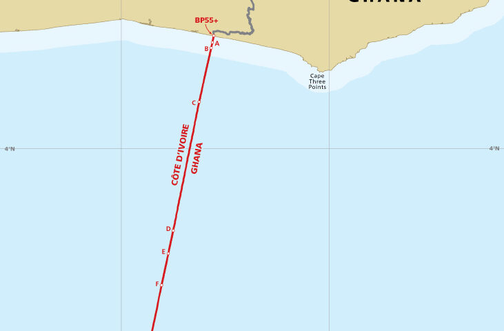
a list of geographical coordinates of points concerning the lines of delimitation of the territorial sea, the exclusive economic zone and the continental shelf between…
View More Ghana maritime claims about delimitation of the territorial sea, the exclusive economic zone and the continental shelf between Ghana and Côte d’IvoireFrance maritime claims about French Polynesia, La Réunion Island, Metropolitan territory of France, Wallis and Futuna Islands, Maritime delimitation between France and the Republic of Suriname and Maritime delimitation between France and Antigua and Barbuda
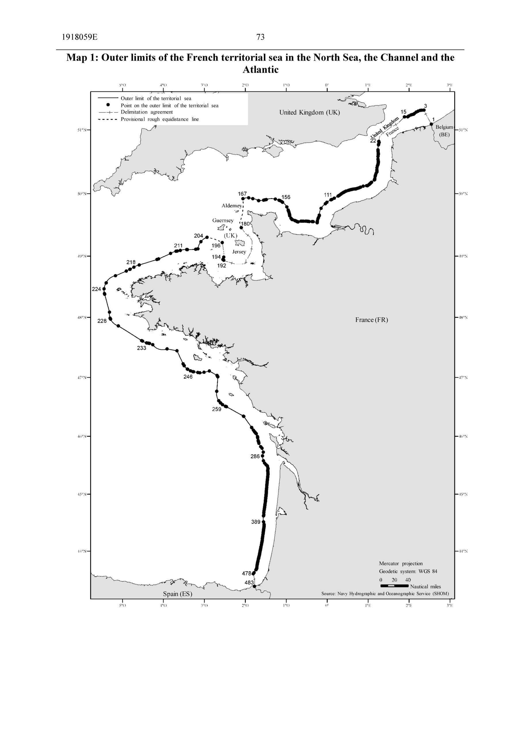
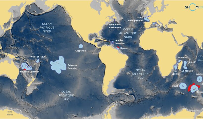
France maritime claims about French Polynesia, La Réunion Island, Metropolitan territory of France, Wallis and Futuna Islands, Maritime delimitation between France and the Republic of Suriname and Maritime delimitation between France and Antigua and Barbuda, Antigua and Barbuda, Areas of France’s maritime spaces of sovereignty, france, France maritime claims, French Polynesia maritime boundary, La Réunion Island maritime boundary, Maritime Claims, Maritime delimitation between France and Antigua and Barbuda, Maritime delimitation between France and the Republic of Suriname, Metropolitan territory of France maritime boundary, Suriname, Wallis and Futuna Islands maritime boundary
View More France maritime claims about French Polynesia, La Réunion Island, Metropolitan territory of France, Wallis and Futuna Islands, Maritime delimitation between France and the Republic of Suriname and Maritime delimitation between France and Antigua and BarbudaFrance maritime claims with Jersey, United Kingdom, Crozet archipelago, Saint Paul Island and Amsterdam Island, Kerguelen Islands and Netherlands
France maritime claims with Jersey, United Kingdom, Crozet archipelago, Saint Paul Island and Amsterdam Island, Kerguelen Islands and Netherlands, Amsterdam Island, Amsterdam Island maritime boundary, Areas of France’s maritime spaces of sovereignty, Crozet archipelago, Crozet archipelago maritime boundary, france, France maritime claims, Kerguelen Islands, Kerguelen Islands maritime boundary, Maritime Claims, netherlands, Saint Paul Island, United kingdom
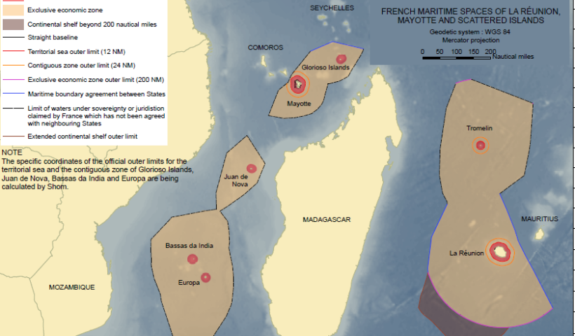
View More France maritime claims with Jersey, United Kingdom, Crozet archipelago, Saint Paul Island and Amsterdam Island, Kerguelen Islands and NetherlandsFrance maritime claims about outer limits of the exclusive economic zone of the Éparses Islands, Mayotte, Reunion Island and Tromelin Island, including lines of delimitation
France maritime claims about outer limits of the exclusive economic zone of the Éparses Islands, Mayotte, Reunion Island and Tromelin Island, including lines of delimitation, Éparses Islands, Éparses Islands maritime boundary, Éparses Islands maritime claims, france, France maritime claims, Mayotte island, outer limits of the exclusive economic zone of Tromelin Island, Reunion Island, Reunion Island maritime boundary, Reunion Island maritime claims, Tromelin Island, Tromelin Island maritime boundary, Tromelin Island maritime claims
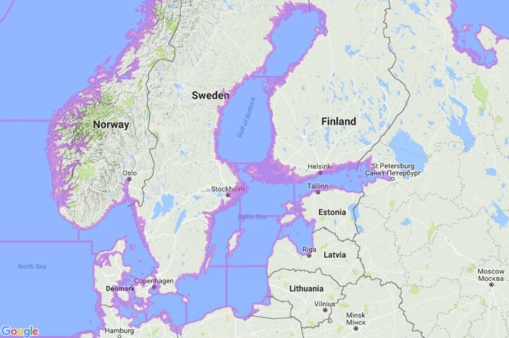
View More France maritime claims about outer limits of the exclusive economic zone of the Éparses Islands, Mayotte, Reunion Island and Tromelin Island, including lines of delimitationFinland claims about straight baselines and the median line separating the continental shelf and fishery zones of Finland from the continental shelves and exclusive economic zones of Estonia and Sweden
Finland claims about straight baselines and the median line separating the continental shelf and fishery zones of Finland from the continental shelves and exclusive economic zones of Estonia and Sweden, Estonia, Estonia maritime boundaries, Finland, Finland continental shelf map, Finland EEZ map, Finland maritime boundaries, Finland maritime claims, Finland straight baselines, Finland territorial sea map, Maritime Claims, Sweden, The Gulf of Finland
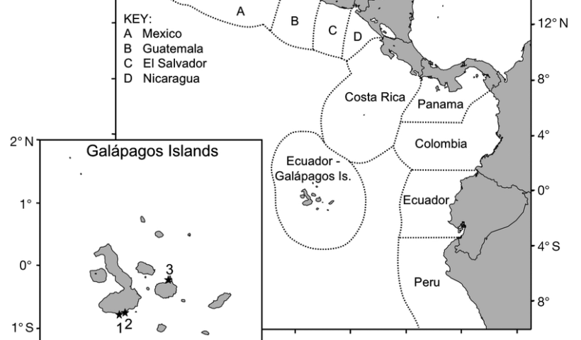
View More Finland claims about straight baselines and the median line separating the continental shelf and fishery zones of Finland from the continental shelves and exclusive economic zones of Estonia and SwedenEcuador claim on the geographical coordinates of points describing the maritime boundaries of its exclusive economic zone and continental shelf with Costa Rica
Ecuador claim on the geographical coordinates of points describing the maritime boundaries of its exclusive economic zone and continental shelf with Costa Rica, costa rica, Costa Rica claim on the exclusive economic zone, Costa Rica Maritime claims, Ecuador, Ecuador continental shelf, Ecuador continental shelf map, Ecuador EEZ map, Ecuador maritime boundaries, Ecuador maritime claims, Ecuador territorial sea map, Map of Ecuador with its Exclusive Economic Zone (EEZ), Maritime Claims
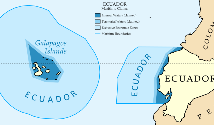
View More Ecuador claim on the geographical coordinates of points describing the maritime boundaries of its exclusive economic zone and continental shelf with Costa RicaEcuador claim on the delimitation of its territorial sea and the exclusive economic zone with Colombia
a chart showing the lines of delimitation of its territorial sea and the exclusive economic zone with Colombia Ecuador is a coastal State located in…
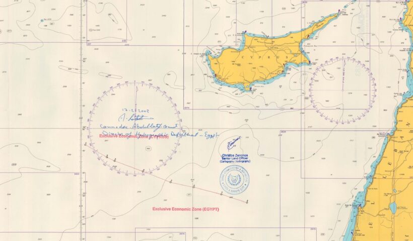
View More Ecuador claim on the delimitation of its territorial sea and the exclusive economic zone with ColombiaCyprus claim about delimitation of the exclusive economic zone Republic of Cyprus and the Arab Republic of Egypt
Cyprus claim about delimitation of the exclusive economic zone Republic of Cyprus and the Arab Republic of Egypt, Cyprus continental shelf map, Cyprus EEZ, Cyprus exclusive economic zone map, Cyprus maritime boundaries, Cyprus maritime claim, Cyprus maritime claims, Egypt, Maritime Claims
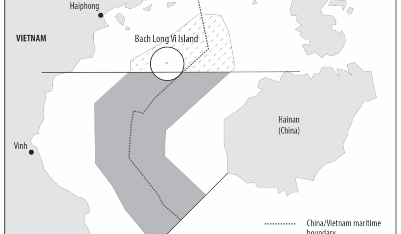
View More Cyprus claim about delimitation of the exclusive economic zone Republic of Cyprus and the Arab Republic of EgyptDelimitation of the Territorial Sea, the Exclusive Economic Zone and Continental Shelf in Beibu Bay between China and Vietnam
Delimitation of the Territorial Sea, the Exclusive Economic Zone and Continental Shelf in Beibu Bay between China and Vietnam, Beibu Bay, China, delimitation, Maritime Boundary Delimitation and SinoVietnamese Cooperation in the Gulf of Tonkin (1994-2016), Maritime Claims, specified in the Agreement between the People’s Republic of China and the Socialist Republic of Viet Nam, Vietnam
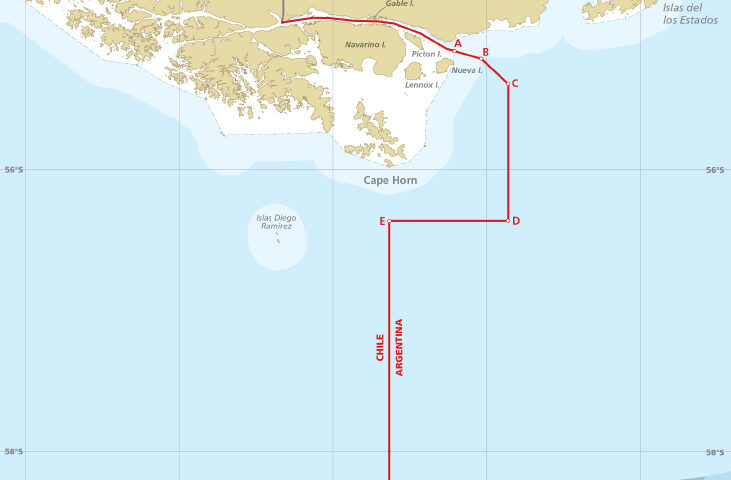
View More Delimitation of the Territorial Sea, the Exclusive Economic Zone and Continental Shelf in Beibu Bay between China and Vietnamchart showing the maritime boundary between Argentina and Chile, with the list of geographical coordinates of points
chart showing the maritime boundary between Argentina and Chile, with the list of geographical coordinates of points, argentina, chile, exclusive economic zone, maritime boundary between Argentina and Chile, Maritime Claims
View More chart showing the maritime boundary between Argentina and Chile, with the list of geographical coordinates of points
