Four conventions opened for signature in 1958 at the First United Nations Conference on the Law of the Sea (UNCLOS I) are among provisions of international law taking effect in the South China Sea: the Convention on the Territorial Sea and the Contiguous Zone, the Convention on the High Seas, the Convention on Fishing and Conservation of the Living Resources of the High Seas as well as the Convention on the Continental Shelf. Of particular interest, however, is the 1982 United Nations Convention on the Law of the Sea, since it supersedes some of the older treaties and incorporates integral components of the 1958 conventions partly verbatim.
Soon after the United Nations Conference on the Law of the Sea (UNCLOS I), technological developments as well as undecided issues (“leftovers”) called for new regulations concerning maritime law. A second conference (UNCLOS II, 1960), however, ended without any formal agreement. Thus, in 1967, then-Maltese Ambassador to the United Nations Arvid Pardo, taking into account technological developments relating to deep-sea explorations of resources, growing pollution, and particularly the rising potential for conflict stemming from unsolved questions of maritime legal claims in the age of Cold War confrontation called for “an effective international regime over the seabed and the ocean floor beyond a clearly defined national jurisdiction” in his address to the General Assembly. When in 1982 the Third Conference on the Law of the Sea (UNCLOS III) presented its final document for signature after nine years of extensive negotiations, participating states had devised one of the most comprehensive agreements throughout international law which—upon its signing in 1982—has been labeled a “Constitution for the Oceans.”
Among the most fundamental provisions of the Convention, which entered into force in 1994, are the legal fixation of different maritime zones, their calculation, and states’ respective rights within them. The Convention, however, provides no provisions as to sovereignty rights and (conflicting) claims of sovereignty. Thus, while it remains “silent on sovereignty over legally defined features,” it contains many provisions as to how certain features are to be characterized and which maritime claims go along with them. On this account UNCLOS is “critically important” for the South China Sea dispute since, as Robert Beckman argues, four questions which are addressed in UNCLOS are among the central topics of relevance for the dispute:
- Which maritime zones may be claimed deriving from the territory of adjacent states and which rights do states enjoy in them?
- Which offshore features may be subject to sovereignty claims?
- Which maritime zones may be claimed deriving from offshore features and which rights go along with them?
- How can claims be harmonized in instances where they overlap or conflict with claims from other states? With its formal recognition by Brunei in November 1996, all claimant states in the South China Sea have become part of UNCLOS and in 2002 the parties reaffirmed their commitment to the Convention with regard to the South China Sea dispute in the Declaration on the Code of Conduct of Parties in the South China Sea.
Measuring the Seas
As argued above, among the central aspects of UNCLOS is its stipulation of different maritime zones to costal states, i.e., states that are adjacent to seas and have a coastline. According to UNCLOS, zones include (1) internal waters, the (2) territorial sea, the (3) contiguous zone, the (4) exclusive economic zone, the (5) continental shelf, the (6) high seas, and the (7) Area. In addition to these zones, the role of offshore features such as islands, rocks, and reefs shall be considered in the following since it is of central importance in the South China Sea dispute. The baseline plays a crucial role in determining the starting point for the delamination of different maritime zones. In principle, the baseline is defined as “the low-water line along the coast as marked on large-scale charts officially recognized by the coastal State.” While ambiguity regarding the determination of the baseline has repeatedly been subject to litigation, UNCLOS stipulates further provisions as to the repercussions of reefs, mouths of rivers, bays, and other geographical features for the calculation of baselines, including the option to draw straight baselines in “localities where the coastline is deeply indented and cut into, or if there is a fringe of islands along the coast in its immediate vicinity.”
- Waters stretching from the landward side on the baseline (including bays, rivers, and lakes) form the internal waters over which the state exerts complete sovereignty and in which the right to innocent passage does not apply. Archipelagic waters of such island states as Indonesia or the Philippines (“archipelagic States”) also fall in this category of internal waters with the distinction that innocent passage must be ensured within archipelagic waters.
- The territorial sea stretches seawards from the baseline. International (customary) law has historically known different methods for delimiting the breadth of territorial sea, which according to the Convention may be claimed “to a limit not exceeding 12 nautical miles.” In their territorial sea the state may exert full ASEAN sovereignty which “extends to the air space over the territorial sea as well as to its bed and subsoil” and thus also includes the exploration of resources within this area. Regarding the territorial sea, Article 17 UNCLOS establishes the right of innocent passage through these waters.
- States have the right to declare a contiguous zone adjoining to the territorial sea. In this zone, which is not permitted to extend beyond a breadth of 24 nm from the baseline, the state enjoys jurisdiction to “prevent infringement of its customs, fiscal, immigration or sanitary laws and regulations within its territory or territorial sea.”
- A maritime zone with particular interest is the exclusive economic zone (EEZ) which stretches up to “200 nautical miles from the baseline from which the breadth of the territorial sea is measured.” In the EEZ the coastal state enjoys sovereign rights for the purpose of exploring and exploiting, conserving and managing the natural resources, whether living or non-living, of the waters superjacent to the seabed and of the seabed and its subsoil, and with regard to other activities for the economic exploitation and exploration of the zone, such as the production of energy from the water, currents and winds.
Additionally, the state has the right to establish artificial islands and structures for economic or scientific purposes and enjoys exclusive jurisdiction over them. In cases in which exclusive economic zones of two or more states overlap, Article 74 (1) UNCLOS obligates states “to achieve an equitable solution.” Article 74 (2) stipulates that if no agreement could be reached bi- or multilaterally, claimant states shall refer to the mechanisms of dispute settlement under Part XV UNCLOS. - An area of particular interest with regard to the exploration of offshore resources is the continental shelf in which huge amounts of oil and gas resources as well as fishery resources are situated. Article 76 (1) UNCLOS, taking into account elder provisions as well as customary law, defines the continental shelf as encompassing the seabed and subsoil of the submarine areas that extend beyond its territorial sea throughout the natural prolongation of its land territory to the outer edge of the continental margin, or to a distance of 200 nautical miles from the baselines from which the breadth of the territorial sea is measured where the outer edge of the continental margin does not extend up to that distance.
As evident in this provision, UNCLOS seeks to compensate states disadvantaged by geological features of their coastlines by allowing them to legally claim a continental shelf to a distance up to 200 nautical miles even if—in a geological sense—the continental shelf does not reach that far. However, this procedure requires “sophisticated studies of the seabed undertaken by the claimant state.”
Additionally, Article 76 (1) also allows the state to claim a prolonged continental shelf extending the 200 nm limit in cases in which geological features permit and under limitations of Article 76 (4) and (5) UNCLOS. If the state seeks to claim a continental shelf extending the 200 nm boundaries, it shall submit this intention to the Commission on the Limits of the Continental Shelf (CLCS). Originally, a deadline setting in with the entry into force of UNCLOS in 1994 and lasting for 10 years had been intended. However, the deadline has subsequently been extended to May 13, 2009, which in part contributed to the flaring up of tensions in the South China Sea that year. Regarding the exploitation of resources, both mineral and living, Article 77 (1) UNCLOS stipulates sovereign rights for the coastal state which, however, “do not affect the legal status of the superjacent waters or of the air space above those waters.” As with the EEZ, a plethora of cases exist in which questions of delimitation between continental shelves of adjacent or opposing states have come up, particularly against the backdrop of the shelf’s huge economic significance and increasing capacities for exploitation. In principle, UNCLOS provides for bi- or multilateral settlement calling for an equitable solution. However, such questions regularly involve great complexity and have frequently had to be decided before international courts such as the International Court of Justice or the International Tribunal for the Law of the Sea.
- All parts of the sea that neither fall under the internal or territorial waters nor under the contiguous or exclusive economic zone are subsumed as the high sea. The legal character of the high sea has been subject to disputes among international law theorists for centuries. According to UNCLOS, the freedom of the sea includes the freedom of navigation, the freedom of overflight, and the freedom to lay submarine cables, among others permissions.
Finally, the Area encompasses “the seabed and ocean floor and subsoil thereof, beyond the limits of national jurisdiction.” According to UNCLOS, the Area and its resources are regarded as “the common heritage of mankind” over which no state may claim sovereignty and in which all activities shall “be carried out for the benefit of mankind as a whole.” Part XI of UNCLOS dealing with the Area thus breaks with the tradition of the freedom of the sea and formulates a special legal status for the ocean floor.
The Role of Offshore Features
Following a basic principle in maritime law after which ‘the land dominates the sea,’ offshore features are of great influence in determining the creation and delamination of maritime zones. Robert Beckman thus argues that against the backdrop of UNCLOS five different categories of offshore features have to be considered regarding differences in their respective ramifications on maritime zones states may derive from them. He thus distinguishes between (1) islands, (2) rocks, (3) low-tide elevations, (4) artificial islands, installations, and structures, and (5) submerged features. Questions concerning the attribution of offshore features under these categories, as shall be demonstrated below, are of particular interest for the dispute in the South China Sea with its hundreds of different offshore features.
According to Article 121 (2) UNCLOS, islands are capable of creating their own territorial sea, contiguous zone, exclusive economic zone, and continental shelf. In a sense, they are therefore treated as representing land territory. For that purpose, Article 121 (1) defines what constitutes an island, “An island is a naturally formed area of land, surrounded by water, which is above water at high tide.” Some offshore features, however, are not capable of inducing the creation of an EEZ or continental shelf. Article 121 (3) thus stipulates, “Rocks which cannot sustain human habitation or economic life of their own shall have no exclusive economic zone or continental shelf.” On first sight, the provisions of Article 121 UNCLOS may seem reasonably clear-cut: An offshore feature, regardless of geographic size or human population, is regarded as an island when (a) it “is a naturally formed area of land” and (b) it “is above water at high tide.” Permanently submerged features thus do not count as islands. Article 121 (3), however, complicates matters greatly. Following its wording, the capability to sustain human habitation or economic life is the decisive criteria for separating a feature capable of creating an EEZ and a continental shelf from features classified as a rock incapable of creating such zones. However, as James Crawford has demonstrated, the wording is unclear; particularly the qualifying phrase: Is past or future existence of human habitation or economic life sufficient to meet these criteria? Is both economic life and human habitation required, and the “or” thus to be understood cumulatively, or either one of them? Thus, while both islands under Article 121 (1) and rocks are undisputedly capable of creating a territorial sea, the question whether or not offshore features whose classification is contested create an EEZ or a continental shelf is highly controversial.
Another variety of offshore features of relevance are low-tide elevations. A lowtide elevation is defined by UNCLOS as “a naturally formed area of land which is surrounded by and above water at low tide but submerged at high tide.” As such it is not entitled to a territorial sea or other maritime zones of its own. However, in situations in which low-tide elevations lie within a “distance not exceeding the breadth of the territorial sea from the mainland or an island, the low-water line on that elevation may be used as the baseline for measuring the breadth of the territorial sea.” Therefore, low-tide elevations, though not able to evoke maritime zones of their own, may well influence the calculation of baselines and subsequently the calculation of maritime zones.
With the exception of the creation of certain safety zones around them, artificial islands, installations, and structures, which do not qualify as islands, do not have a territorial sea of their own and neither do they effect the delimitation of maritime zones. However, as argued above, states enjoy exclusive jurisdiction over artificial islands, installations, and structures in the EEZ under UNCLOS.
Finally, submerged features such as reefs perpetually under sea level at high and low tide do not qualify as an island under Article 121 (1) UNCLOS. Therefore, they do not enable states to derive any separate maritime zones from them.
The Actors’ Claims with Respect to International Law
How can actors’ respective claims in the South China Sea be assessed from the perspective of international law? Over the years, all claimant states in the South China Sea have claimed a baseline, a territorial sea, an exclusive economic zone, and a continental shelf through respective domestic legislation. Among claimant states, claims by China and Taiwan, which ostensibly make congruent claims, are by far the most expensive in the South China Sea and shall therefore receive particular attention. One of the key problems in determining different claims and assessing its compatibility with UNCLOS, however, is inadequate information, particularly with regard to Chinese claims. For these reasons, claims have to be inferred from state practice and declarations in cases in which statements are absent or equivocal.
At first, not least because of their significance for the calculation of adjacent maritime zones, the baselines claimed by states in the South China Sea have to be considered. China, Taiwan, and Vietnam have each declared straight baselines under the provisions of Article 7 UNCLOS. While maps submitted to the CLCS seem to indicate a similar course of action by Malaysia, it still has not officially published declarations to that effect, causing the legality of its baselines to be intentions to act in accordance with international law in the measurement of territorial waters. Since no contrary statement has been published by Brunei, as it is required under Article 16 (2) UNCLOS, it may be assumed that the state applies the normal baseline under Article 5 UNCLOS.106 The Philippines, an “archipelagic State” under Article 46 UNCLOS, has declared archipelagic baselines
in accordance with Article 47 UNCLOS. All things considered, questions regarding the legality of baselines claimed by some of the states remain. However, although among claimant states no one has officially protested against the baselines of its neighbors, persistent obscurities regarding the legality of some of the baselines and the connected rights of innocent passage are likely to bring the United States and other (naval) powers to the scene.
Regarding maritime zones claimed from (regular, straight, or archipelagic) baselines, precise delimitations still appear unclear in a number of cases. Albeit, claims of some states, for example those of the Philippines, have been “improving in clarity.” Additionally, the Philippines have indicated their intentions to make a submission to CLCS regarding the outer limits of its continental shelf. Thus, while China is likely to object to any future claims submitted by the Philippines, prospective Philippine declarations should clarify the situation. Further unilateral declarations, including one of Brunei in 1988, added clarity. Additionally, Malaysia and Vietnam undertook joint action in 2009 in order to identify thei claims before the end of the May deadline and thus presented a joint submission to the CLCS in accordance with Article 76 (8) UNCLOS. In their submission they provided “information on the limits of the continental shelf beyond 200 nautical miles from the baselines from which the breadth of the territorial sea is measured in respect of the southern part of the South China Sea.” Additionally, Vietnam submitted a separate declaration to CLCS in 2009, further clarifying its claims concerning the limits of its continental shelf in the northern part of the South China Sea. Notes verbales submitted by China and the Philippines in immediate reaction to these submissions objected to the Vietnamese and Malaysian claims and thus the CLCS—according to its rules of procedure —is unlikely to consider the submissions, albeit they have contributed to greater clarity with regard to maritime claims.
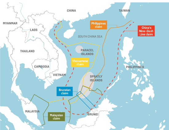
The note verbale submitted by China the day following the joint submission by Malaysia and Vietnam in May 2009 is important from another perspective as well. For attached to the formal objection to the Malaysian and Vietnamese claims, China submitted for the first time a map in diplomatic documents showing the infamous nine-dashed line, which for long has been a point of contention regarding Chinese claims in the South China Sea. First drawn in the 1930s as internal governmental documents, maps showing Chinese maritime boundaries by a number of dashes or lines began to be published by the Republic of China and were later adopted by the People’s Republic of China as well. Nearly the entire South China Sea falls within the u-shaped area outlined by the dashes that later have been reduced to nine. Although by now the line appears on official Chinese maps and passports, its legal status remains contested and largely undefined. China, however, insists on the compatibility of the nine-dashed line with international law in general and UNCLOS in particular. And although—from the perspective of international law—the line may be of little relevance, its psychological and political impact may be incomparably greater.
Regarding China’s maritime claims in the South China Sea great ambiguity prevails. A Chinese “policy of ‘strategic ambiguity’” may very well be in the interest of Beijing which avoids taking a clear position. However, it complicates matters regarding the assessment of Chinese claims and compels observers to interpret ambiguous statements. Thus, some observers argue that any “reasonable reading” of the map could only mean “that China claims all islands inside the ushaped line and the waters and continental shelf that can be generated by those islands on the basis of the principles laid down in the law of the sea.” China therefore seems to claim about 80 % of the South China Sea by drawing on historic rights predating UNCLOS and other provisions of modern international law. The 1998 Exclusive Economic Zone and Continental Shelf Act thus explicitly states that provisions set down therein “shall not affect the rights that the People’s Republic of China has been enjoying ever since the days of the past.” This conundrum concerning the reconcilableness of international law with Chinese concepts of sovereignty is a further factor complicating the South China Sea dispute and may be regarded a litmus test for China’s approach to international law with its predominantly Western character in general and the law of the sea in particular.
As the overview over maritime claims by adjacent states in the South China Sea has shown, several points of contention exist between claimants that would require a number of bi- or multilateral agreements in order to reconcile claims. The situation, however, is even further complicated by the role of offshore features. In the following, the role of the Spratly and Paracel Islands shall be considered in particular against this backdrop.
As argued above, there are some clear-cut cases regarding the classification of offshore features. Itu Aba, largest of the Spratly Islands, for example, undisputedly constitutes an island and is therefore entitled to a continental shelf and an EEZ of its own. The same holds true with regard to Woody Island, largest islands of the Paracels. At the same time, certain perpetually submerged features are agreed upon to not justify any maritime claims. However, there are countless cases lying in between these two positions. The first problem regarding these cases of dispute is that the number of offshore features in the South China Sea itself remains ambiguous.
Gregory B. Poling, however, offers an essay in counting features and holds that in total 50 features in the South China Sea can by defined as islands under UNCLOS. Furthermore, he presents a concise list of islands to be found in the island groups of the Spratlys and the Paracels. Poling thus classifies “to the best of the author’s [Poling’s] knowledge” nine features attributed to the Paracels and thirty features attributed to the Spratlys as islands under UNCLOS.
Besides difficulties in identifying the number of offshore features in the South China Sea, matters are further complicated by the fact that none of the claimant states have conclusively indicated which of the features they consider to constitute islands under UNCLOS. Any researcher has therefore to resort to public statements and declarations as well as draw inferences from state practice from the perspective of a reasonable observer. Table 2.1 introduced above may serve as a point of reference in this regard. Brunei thus has not made any claims with regard to both the Spratly and the Paracel Islands. China and Taiwan, on the other hand, state the most extensive claims, which seem to be based rather on historic rights than on UNCLOS. Besides claiming the islands due to century-old traditions, they particularly refer to naval expeditions in the late 1940s under Chiang Kai-shek to the Spratly and Paracel Islands as well as to their permanent presence on the largest islands of these groups. In the context of negations for the 1951 Treaty of San Francisco, ending U.S. occupation of Japan and settling various territorial disputes, Premier of the People’s Republic of China Zhou Enlai issued a statement which claimed sovereignty over the Spratlys and Paracels for China and which reaffirmed in later years—still represents the basis for Chinese claims today. In the 2009 note verbale already mentioned above, China thus holds that it has indisputable sovereignty over the islands in the South China Sea and the adjacent waters, and enjoys sovereign rights and jurisdiction over the relevant waters as well as the seabed and subsoil thereof (see attached map). The above position is consistently held by the Chinese Government, and is widely known by the international community.
As argued above, the attached map contained the nine-dashed (or u-shaped) line, which is of particular importance concerning an identification of Chinese claims regarding offshore features in the South China Sea, particularly the Spratlys and Paracels. As to the understanding and interpretation of the 2009 note verbale in this regard, different approaches exist. On the one hand, the first part of the sentence quoted from the note (“indisputable sovereignty over the islands in the South China Sea and the adjacent waters”) may very well be read as referring to the territorial sea created by islands and thus be in accordance with the respective provisions in UNCLOS. On the other hand, the second part of the sentence (“enjoys sovereign rights and jurisdiction over the relevant waters as well as the seabed and subsoil thereof”) is evocative of terms applied by UNCLOS with regard to rights enjoyed in the EEZ and continental shelf. While the term “relevant waters” remains ambiguous, a reading of this second part would allow for the assumption that China was claiming rights of sovereignty and jurisdiction within the total area marked by the nine-dashed line. Understandingly, protests with regard to the ambiguous note were not long in coming. China, however, reaffirmed its position in a 2011 note verbale arguing that China has indisputable sovereignty over the islands in the South China Sea and the adjacent
waters, and enjoys sovereign rights and jurisdiction over the relevant waters as well as the seabed and subsoil thereof. China’s sovereignty and related rights and jurisdiction in the South China Sea are supported by abundant historical and legal evidence.
Instead of referring to the nine-dashed line and its undefined legal status, China in its 2011 note claimed “abundant historical and legal evidence.” Again, as already mentioned above, history and historic rights are evoked in particular with regard to the Spratly and Paracel Islands. The role of history or historic claims in international law, however, has been a matter of controversy and litigation for decades in other instances as well.
Nevertheless, while under UNCLOS historic claims or rights are not recognized, China insists on these rights in the South China Sea, as statements from Chinese officials indicate. Some Chinese commentaries thus argue “that their historical notions of sovereignty predate Western international law and should be recognizes as valid ab initio” and accordingly UNCLOS cannot be applied. To this end, China, upon its ratification of UNCLOS in 1996, exercised its right after Article 310 UNCLOS to make declarations or statements regarding the application of the Convention. In the statement China refers to Article 2 of its Law on the Territorial Sea and the Contiguous Zone (1992) already cited above and lists the Spratlys and the Paracels (as well as islands in the East China Sea) as Chinese land territory. While China is entitled to make declarations under Article 310 UNCLOS, the same article also states that any statements made “do not purport to exclude or to modify the legal effect of the provisions of this Convention.” Such, however, is the case with regard to the provisions set down in the declaration made by China in 1996 and invoking these rights, therefore, stands in contrast to the provisions of UNCLOS. While UNCLOS only briefly mentions the concept of historic waters, customary laws accepts it with regard to bays and allows states extended jurisdiction in cases in which claims have been open, long-standing, exclusive, and widely accepted by other states. These criteria, however, are hardly met in regard to the South China Sea, particularly since ancient Chinese records mention the Paracel Islands but are silent on the Spratlys.
Therefore, while the first part of the 2011 note verbale may be in line with UNCLOS, the reference to historic rights is not covered by the Convention. Leaving room for varied interpretation once more underlines China’s “policy of ‘strategic ambiguity.’” However, although ambiguity remains, recent years have seen slight changes towards formulating claims in accordance with international law and particularly UNCLOS rather than clinging to historical claims. As indicated by their recent actions and submissions to the CLCS, Malaysia and Vietnam endeavor to formulate their positions, which are more precise, in conformance with international law. Vietnam, as already indicated in Table 2.1, however, makes extensive claims with regard to the Spratlys and Paracels as well. In a 2009 note verbale to the CLCS in response to China’s claims Vietnam thus argues,
The Hoang Sa (Paracels) and Truong Sa (Spratlys) archipelagos are parts of Viet Nam’s territory. Viet Nam has indisputable sovereignty over these archipelagos. China’s claim over the islands and adjacent waters in the Eastern Sea (South China Sea) . . . has no legal, historical or factual basis, therefore is null and void.
In view of recent actions, statements, and legislation of said states, however, Robert Beckman holds that Vietnam, Malaysia, and the Philippines seek to bring their positions in line with UNCLOS and “view the South China sea through the lens of international law, particularly UNCLOS.”
I’d like to ask your view on US economic narrative in the South China Sea. Where do you think it stands now? On the security side, Ashton Carter and others are quite proactive in escalating their rhetoric. But on the economic side, the American narrative, TPP, now stands in jeopardy. Whether or not it will be ratified either before or after the change in presidency is very much up in the air. China’s successful narrative in Southeast Asia has been primarily economic. Do you see the change in the presidency as working toward China’s continuing successful conversation with Southeast Asia?