Analyzing Argentina and Chile’s Maritime Disputes: Law of the Seas
View More Analyzing Argentina and Chile’s Maritime Disputes: Law of the Seas
Analyzing Argentina and Chile’s Maritime Disputes: Law of the Seas
View More Analyzing Argentina and Chile’s Maritime Disputes: Law of the SeasThe maritime disputes between Argentina and Uruguay have been a long-standing issue, originating from conflicting territorial claims and exclusive economic zone (EEZ) boundaries. These disputes revolve around the shared waters of the Rio de la Plata and the South Atlantic Ocean, and have significant implications for the countries’ bilateral relations, regional stability, and economic development. In this article, we will analyze the legal framework surrounding these disputes, examine the key issues at hand, explore historical precedents of resolution attempts, discuss the role of diplomacy, evaluate the viability of arbitration and the International Court of Justice, address environmental concerns, and assess the potential implications of these disputes on the marine ecosystem and economic development in the region.
View More Analyzing Argentina-Uruguay Maritime Disputes: Navigating the Law of the SeasArgentina, located in the southernmost region of South America, possesses a vast coastline that stretches over 4,800 kilometers. This extensive maritime territory presents Argentina with significant challenges and opportunities in the realm of international law. From disputes over maritime borders to concerns regarding maritime security and environmental conservation, Argentina faces a complex set of issues that require careful analysis and consideration. This article aims to delve into Argentina’s maritime challenges, examining its current legal framework, disputes and claims, security concerns, environmental impact, and future prospects.
View More Analyzing Argentina’s Maritime Challenges in International Law: Seas, Security, and Beyond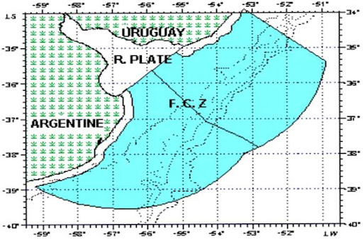
In 1973 Argentina and Uruguay concluded an agreement (1973 Agreement) concerning overlapping claims to the Río de la Plata and maritime zones seaward of a closing line at the mouth of the river. Seaward of the closing line, the 1973 Agreement establishes a ‘lateral maritime boundary’ and boundary of the continental shelf, which are both defined by a single equidistance line. The closing line and lateral maritime boundary are depicted in Figure. The lateral maritime boundary delimits several jurisdictional competencies recognized in the Agreement, which relate to: the exploration, conservation, and exploitation of resources; control and supervision of fishing activities; protection and preservation of the environment; scientific research; and construction and emplacement of installations. Viewing this delimitation of competencies in light of LOSC Part V, it is reasonable to regard the lateral maritime boundary as a delimitation of the EEZ and associated coastal state jurisdiction.
View More Argentina–Uruguay overlapping claims concerning boundary delimitation and the Río de la Plata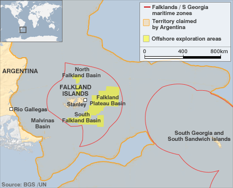
Argentina and the United Kingdom both claim sovereignty over the Falkland/Malvinas Islands, South Georgia and the South Sandwich Islands, and assert a variety of overlapping maritime claims appertaining to these South Atlantic features. Several features currently occupied and administered by the United Kingdom and were the focus of an armed conflict between the two States in 1982. In the immediate aftermath of the conflict the United Kingdom declared a 150 nautical mile ‘Falkland Island Protection Zone’ (FIPZ) designed to restrict and control the navigation of Argentinean vessels in waters surrounding the Islands. In 1986 the United Kingdom supplemented its 3 nautical mile territorial sea claim around the Falkland Islands by (1) declaring an ‘Interim Conservation and Management Zone’ (FICZ) projected 150 nautical miles from a fixed point located in the center of the Islands, and (2) reiterating its claim to the continental shelf surrounding the Islands.The limits of the FIPZ and FICZ are illustrated in Figure. The primary concern influencing the declaration of the FICZ was the rapid and unsustainable escalation of commercial fishing in waters surrounding the Islands between 1982 and 1986. The declaration of the FICZ and reiterated continental shelf claim prompted Argentina to issue a protest note reaffirming its sovereignty claim to the Islands and ‘its rights of sovereignty and jurisdiction over the surrounding maritime waters, sea-bed and marine sub-soil, rights which it will continue to exercise in its capacity as a coastal State in accordance with international law.’ In 1989 both States entered into negotiations with a view to normalizing diplomatic relations after they were broken off during the 1982 conflict. Design features of provisional joint management frameworks:
View More Argentina–United Kingdom: overlapping claims in the South Atlantic and Southern Oceans(Falkland/Malvinas Islands)
chart showing the maritime boundary between Argentina and Chile, with the list of geographical coordinates of points, argentina, chile, exclusive economic zone, maritime boundary between Argentina and Chile, Maritime Claims
View More chart showing the maritime boundary between Argentina and Chile, with the list of geographical coordinates of points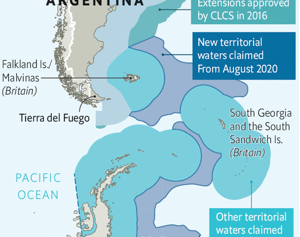
charts (straight baselines and outer limits of the EEZ) and lists of geographical coordinates (straight baselines)of Argentina, argentina, argentina coastline, Argentina continental shelf, argentina maritime claims, Argentine Sea, Argentine Sea map, De Faro Punta Mogotes a Faro Claromecó, De Faro Punta Norte a Faro San José, De Faro San Antonio a Faro Miramar, De Faro Segunda Barranca a Faro Punta Bajos, El Rincón, Estrecho de Magallanes – De Cabo Vírgenes a Bahía San Sebastián, Image of Argentine Sea map Argentine Sea map, Islas Malvinas, Islas Sandwich del Sur, Maritime Claims, Río de la Plata exterior
View More charts (straight baselines and outer limits of the EEZ) and lists of geographical coordinates (straight baselines)of Argentina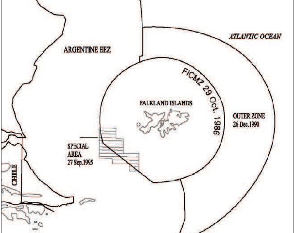
Practice on Provisional Arrangements in maritime Disputed Areas, JOINT DEVELOPMENT ZONES, United Kingdom-Argentina in the South West Atlantic case, argentina, continental shelf, Falkland Islands, JOINT DEVELOPMENT ZONES, Madrid Formula, South West Atlantic, United kingdom
View More Practice on Provisional Arrangements in maritime Disputed Areas, JOINT DEVELOPMENT ZONES, United Kingdom-Argentina in the South West Atlantic case
On 14 November 2012, Argentina filed with the Tribunal a request for the prescription of provisional measures under article 290, paragraph 5, of the Convention in a dispute concerning “the detention by Ghana […] of the warship ‘ARA Fragata Libertad’”. The case was entered into the Tribunal’s list of cases as Case No. 20.
View More The “ARA Libertad” Case (Argentina v. Ghana)