Maritime Matters of Bangladesh: Law of the Seas and Security

Bangladesh is a maritime nation with a coastline of over 580 kilometers. It is home to deep, diverse, and invaluable marine resources, and its geography and climate make it vulnerable to natural disasters and extreme weather events. Maritime matters, including the law of the seas, sea security, and maritime resource management, are of great importance to Bangladesh. This article will explore how Bangladesh is addressing these maritime matters to ensure the safety and security of its people, resources, and environment.

View More Maritime Matters of Bangladesh: Law of the Seas and Security
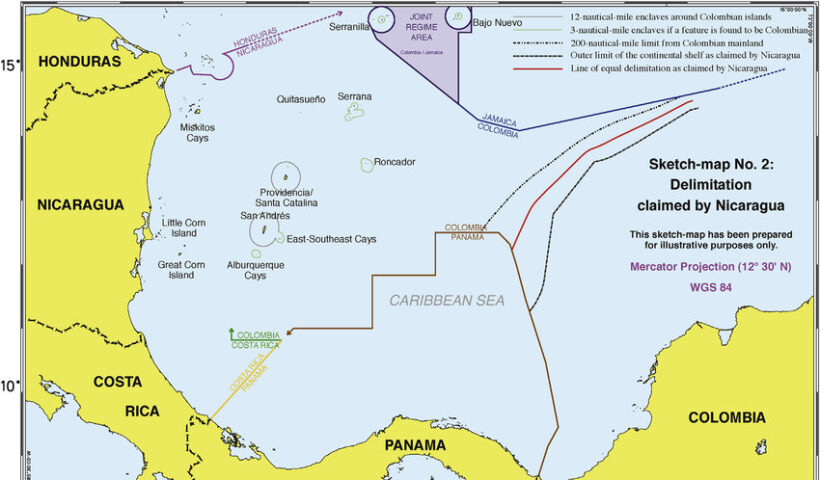
Map Showing Overlap Of ECS Claim Nicaragua And 200 Nm Delimitation Line Columbia 820x480

Delimitation of the Continental Shelf Beyond 200 Nautical Miles in law of the sea and customary international law

The delimitation of the continental shelf beyond 200 nautical miles is a comparatively new subject in the law of maritime delimitation. In this regard, three issues need further consideration: (i) entitlements to the continental shelf beyond 200 nautical miles, (ii) the relationship between the CLCS and an international court or tribunal, and (iii) the methodology.. Delimitation of the Continental Shelf Beyond 200 Nautical Miles in law of the sea and customary international law, Bangladesh/India case, Bangladesh/Myanmar case, continental shelf, Delimitation of the Continental Shelf, Delimitation of the Continental Shelf Beyond 200 Nautical Miles, Ghana/Côte d’Ivoire cases, LOSC, maritime delimitation, What are the characteristics of the continental shelf?, What does continental slope mean?, What extended continental shelf?, What is continental shelf limit?, What is the importance of continental shelf?, What is the largest continental shelf?, Where is the continental shelf?

View More Delimitation of the Continental Shelf Beyond 200 Nautical Miles in law of the sea and customary international law
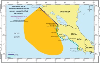
49739fig3 8

Configuration of Coasts as a RELEVANT CIRCUMSTANCES in delimitation process in law of the sea and customary international law

Configuration of Coasts as a RELEVANT CIRCUMSTANCES in delimitation process in law of the sea and customary international law, Bangladesh/India Arbitration, Bangladesh/Myanmar case, Configuration of Coasts, delimitation process, equidistance line, equidistance method, geographical factors, Guinea/ Guinea-Bissau case, ITLOS, Libya/Malta judgment, line grosso modo, macrogeography, manifestly concave, maritime delimitation, North Sea Continental Shelf cases, opposite and adjacent coasts, provisional equidistance line, relevant circumstances

View More Configuration of Coasts as a RELEVANT CIRCUMSTANCES in delimitation process in law of the sea and customary international law
Home 820x480

DEVELOPMENT OF CASE LAW RELATING TO MARITIME DELIMITATION

DEVELOPMENT OF CASE LAW RELATING TO MARITIME DELIMITATION, 1977 Anglo-French Continental Shelf case, an equitable result, Bangladesh/India Arbitration, Bangladesh/Myanmar case, Black Sea case, Cameroon/Nigeria case, continental shelf, corrective-equity approach, EEZ, equidistance method, equidistance/relevant circumstances method, equitable criteria, Equitable Principles, equitable result, Eritrea/Yemen Arbitration, Ghana/Côte d’Ivoire case, Greenland/Jan Mayen case, Gulf of Maine case, Guyana/Suriname Arbitration, maritime delimitation, Nicaragua/Honduras case, North Sea Continental Shelf judgment, Pierre and Miquelon Arbitration, provisional delimitation line, Qatar/Bahrain case, relevant circumstances, resultorientated equity approach, single combined equidistance–special circumstances rule, special circumstances, test of disproportionality, three-stage approach to maritime delimitations, Tunisia/Libya case, What are the stages of maritime boundary?, What is a single maritime boundary?, What is delimited boundary?, What is maritime space?, What is median line principle?, What is the difference between demarcation and delimitation?, Which law delimits world seas?

View More DEVELOPMENT OF CASE LAW RELATING TO MARITIME DELIMITATION