Navigational Regimes of Particular Straits, Torres Strait case study

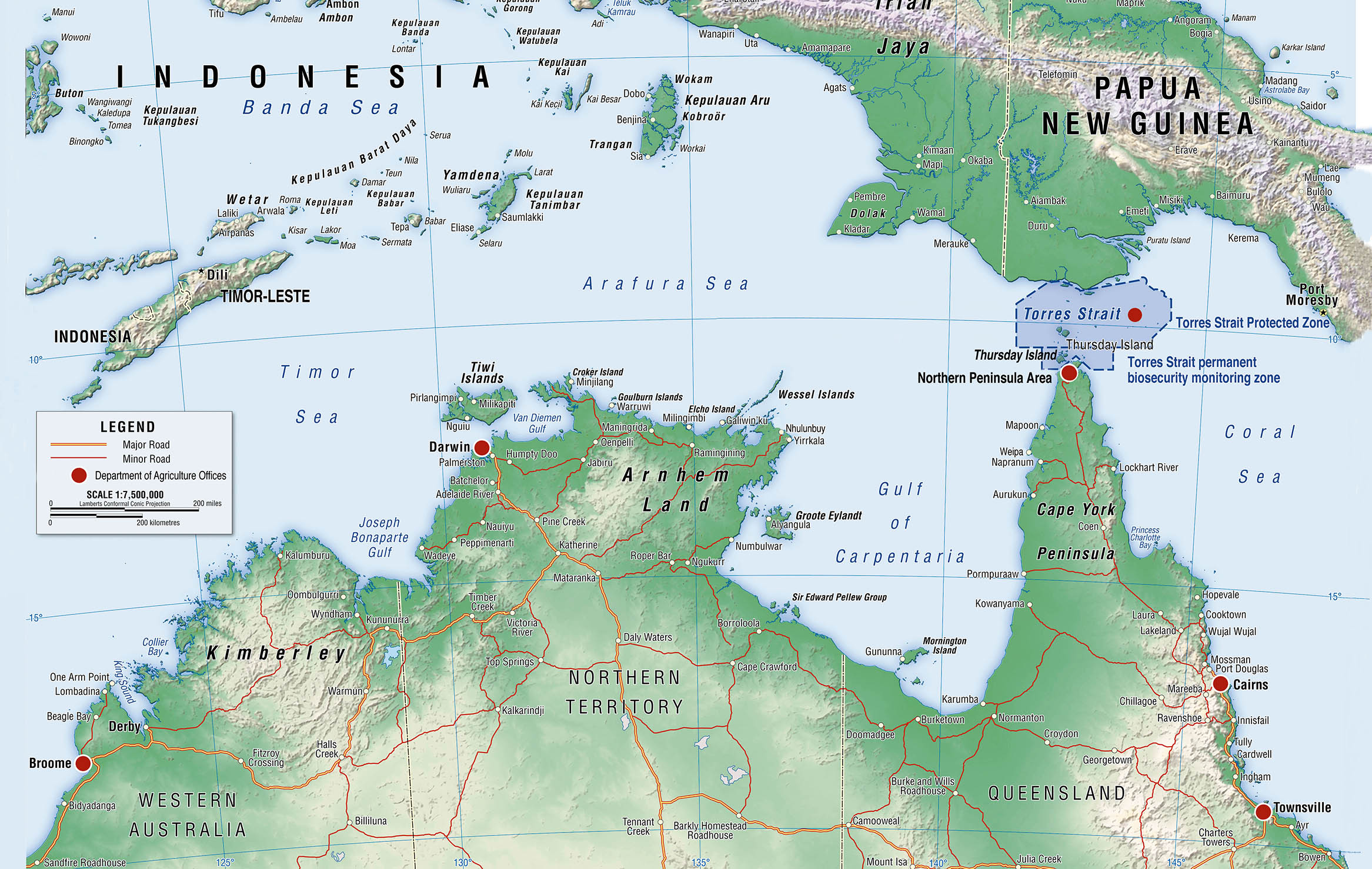
The Torres Strait has been defined as the area of water between Cape York Peninsula in Australia’s extreme north coastline and the islands of New Guinea. It is bounded in the west by the Arafura Sea and in the east by the Great Barrier Reef and the Coral Sea. The strait is about 81 miles (150 km) wide and almost 108 miles (200 km) long between the islands at its eastern and western ends. The strait is, however, shallow and contains reefs and many small islands.

View More Navigational Regimes of Particular Straits, Torres Strait case study

Navigational Regimes of Particular Straits, Tiran case study

Navigational Regimes of Particular Straits, Tiran case study, 1979 Treaty of Peace between Egypt and Israel, Gulf of Aqaba, Navigational Regimes of Particular Straits, Strait of Tiran, the Gulf of Aqaba, The Strait of Tiran, The strategic importance of the strait of Tiran, What is the body of water between the Red Sea and the Arabian Sea?, What is the importance of the Straits of Tiran?, What is the meaning of strait?, What separates Saudi Arabia from Egypt and Israel?, Who owns Tiran Island?

View More Navigational Regimes of Particular Straits, Tiran case study

Navigational Regimes of Particular Straits, Sunda and Lombok case study

Sunda Strait, located between the Indonesian islands of Sumatra and Java, provides the major sea link between the Indian Ocean and the Java Sea and into East Asian waters. (See Map 25 above.) It is approximately 50 miles long, and at its narrowest point is 13.8 miles wide. Sangian Island separates the 2.4-milewide western channel and the 3.7-mile-wide eastern channel. Sunda’s governing depth is about 100 feet but is not considered suitable for submerged passage given the hydrographic characteristics of its northern exit and the extent of its commercial use.. Navigational Regimes of Particular Straits, Sunda and Lombok case study, How deep is the Lombok Strait?, How did Sunda Strait tsunami happen?, How many straits are there in the world?, Lombok Strait, Navigational Regimes of Particular Straits, Sunda and Lombok, Sunda Strait, The Indo-Pacific’s maritime choke points, What is the meaning of strait?, Where is Sunda Strait?, Which strait connects Java Sea to Indian Ocean?

View More Navigational Regimes of Particular Straits, Sunda and Lombok case study

Navigational Regimes of Particular Straits, Baltic Straits(The Oresund and the Belts) case study

Navigational Regimes of Particular Straits, Baltic Straits(The Oresund and the Belts) case study, Baltic Straits, Danish straits, Danish Straits maritime chokepoints, Great Belt, Little Belt, Navigational Regimes of Particular Straits, Sound (Oresund), The Oresund and the Belts, What is the strait between Denmark and Sweden?, What separates the North Sea from the Baltic Sea?, What strait is between Denmark and Norway?, Where is the Baltic Strait?, Where is the Kattegat Strait?

View More Navigational Regimes of Particular Straits, Baltic Straits(The Oresund and the Belts) case study

Navigational Regimes of Particular Straits, Bonifacio case study

Navigational Regimes of Particular Straits, Bonifacio case study, Bonifacio case study, French island of Corsica, Italian island of Sardinia, Messina Strait, navigation in the Strait of Bonifacio, Navigational Regimes of Particular Straits, Particular Straits, Particularly Sensitive Sea Area, ResearchGate The Bonifacio Strait area, transit of the Strait of Bonifacio

View More Navigational Regimes of Particular Straits, Bonifacio case study