Approaches to delimitation of maritime boundaries

The establishment of continental shelf zones and exclusive economic zones
(EEZs) considerably increased the number and length of the maritime
boundaries between coastal states. A 1983 survey identified some 376
international maritime boundaries between 137 coastal states around the
globe. In 1988, the US Department of State gave a figure of 412 demarcations
required. Eventually, additional boundaries arose due to the advent
of new states and the breaking-up of the Soviet Union. Yet another
generation of boundaries will result from climate change and accessibility
to resources in the Arctic waters.

View More Approaches to delimitation of maritime boundaries

Development of the Studies on Maritime Delimitation

Since 1945, in particular, many studies have been written in the field of maritime delimitation. Most of them have focused on the case law. In fact, as is shown in the bibliography, there are many articles relating to international judgments in this field. Since it has been argued that the law of maritime delimitation has developed through international jurisprudence, it was only natural that writers turned to the analysis of case law in this field.

View More Development of the Studies on Maritime Delimitation

Importance of Maritime Delimitation in International Law of the Sea

MARITIME SPACES IN international law of the sea are, in essence, defined in relation to the coastal State jurisdiction over each maritime space. Thus, coastal State jurisdiction is the primary criterion in characterising maritime spaces. The ambit of coastal State jurisdiction is in principle defined spatially, based on distance from the coast. According to the 1982 UN Convention on the Law of the Sea, the territorial sea in which a coastal State exercises territorial sovereignty shall not exceed 12 nautical miles measured from the relevant baseline (Article 3). The contiguous zone over which a limited jurisdiction is exercised by the coastal State may not extend beyond 24 nautical miles from that line (Article 33). The Exclusive Economic Zone (EEZ), where the coastal State may exercise sovereign rights regarding the exploration and exploitation of natural resources, shall not extend beyond 200 nautical miles (Article 57). The same is in principle true for continental shelves of less than 200 nautical miles (Article 76(1)). It would seem safe to say that these rules have now become customary law. Hence, the definition of the spatial extent of coastal State jurisdiction is at the heart of the international law of the sea.

View More Importance of Maritime Delimitation in International Law of the Sea

Denmark(Faroe Islands)–United Kingdom maritime boundary and Special Area

In May 1999 Denmark and the United Kingdom concluded an agreement (1999 Agreement) concerning their overlapping claims to fisheries zones and continental shelf in North Atlantic waters located between the Faroe Islands and Scotland. The 1999 Agreement designates continental shelf and fisheries zone boundaries in addition to a ‘Special Area’ of water column that remains subject to the overlapping jurisdictional claims both States.

View More Denmark(Faroe Islands)–United Kingdom maritime boundary and Special Area

Colombia–Jamaica maritime boundary and the Joint Regime Area

In 1993 Colombia and Jamaica concluded a treaty (1993 Treaty) concerning their overlapping claims to a continental shelf and EEZ in the Caribbean Sea. Article 1 of the 1993 Treaty establishes a maritime boundary between the two States. Immediately to the west of the boundary, the 1993 Treaty also establishes a ‘Joint Regime Area’ in which, ‘pending the determination of the jurisdictional limits of each Party …, the Parties agree to establish … a zone of joint management, control, exploration and exploitation of living and non-living resources’. Article 3(1), sub-paragraphs (b) and (c) of the 1993 Treaty exclude two circular areas of 12 nautical miles radius from the Joint Regime Area. One circular area surrounds the cays of the Seranilla Bank and the other surrounds the cays of Bajo Nuevo. Both of these groups of features are claimed by Colombia – a claim that has been disputed on various occasions by Honduras, Jamaica, Nicaragua and the United States.

View More Colombia–Jamaica maritime boundary and the Joint Regime Area

Canada–United States overlapping claims in North Atlantic and surrounding Machias Seal Island and North Rock

In 1979 the Canada and the United States agreed to empower a Chamber of the ICJ to designate a single seabed and water-column boundary in the Gulf of Maine. The Chamber’s 1984 Judgment establishes a segmented boundary that commences at an offshore point mutually agreed by both States (Point A) and terminates at the point of intersection with the United States’ 200 nautical mile limit. McDorman notes that, prior to the conclusion of the 1979 agreement, Canadian and US negotiators had proposed several options concerning provisional joint management of overlapping claims in the Gulf of Maine. These proposals did not gain traction because delimitation issues proved difficult to set aside. In particular, the location of competing boundary claims influenced political views concerning the fair division of fisheries and potential hydrocarbon resources.

View More Canada–United States overlapping claims in North Atlantic and surrounding Machias Seal Island and North Rock

The Development of the Case Law of Maritime Delimitation: From Equity to Normativity

In parallel with the codification process in the 1958 Geneva Conventions and the 1982 UNCLOS, the law of maritime delimitation was subject to a progressive development through litigation and arbitration. Both processes were at the same time independent and interrelated. The scope of this part is to provide a broad historical background of the evolution of the case law of maritime delimitation in order to better analyze in the following section the conditions, under which the Equidistance/Relevant Circumstances principle had emerged and developed.

View More The Development of the Case Law of Maritime Delimitation: From Equity to Normativity

Codification of Maritime Delimitation

The first attempt at codification of the customary law of maritime delimitation started with the 1930 Hague Conference under the auspices of the League of Nations. The Hague Conference failed to reach its purpose and the following World War II period was not an appropriate period to deal with issues of maritime delimitation. In the aftermath of World War II, the creation of the United Nations Organization (UN) and the multiple individual claims of States over maritime spaces, such as the Truman Proclamation and the Santiago Declaration raised the need of re-starting the process of codification of the law of maritime delimitation. The adoption of the 1958 Geneva Conventions which followed was a successful initiative, at least to some extent.

View More Codification of Maritime Delimitation

what is the meaning of Thalweg Line

The thalweg line is a concept of river law, defined under customary law either as “the mid-line of the main navigation channel” or as the deepest water line. The purpose of the thalweg line in matters of delimitation is to ensure an equal share of the navigable channel between two sovereign States taking into account the navigation interests. As compared to the median-line, the thalweg line as single rule was less used for maritime delimitation in State practice; one example is the Alaska Boundary Arbitration between Great Britain and the United States in 1903.

View More what is the meaning of Thalweg Line

what is the meaning of single maritime boundaries line (single line with dual purpose or all-purpose line)

In theory, the delimitation of the exclusive economic zone could follow a different line than the continental shelf. For practical reasons, however, states seem to have wanted to have their maritime zones delimited by a single maritime boundary for all purposes. The reason for this lies first of all in the shared overlap of natural resources between the two zones.

View More what is the meaning of single maritime boundaries line (single line with dual purpose or all-purpose line)

Three-stage Approach of Maritime Delimitation in law of the sea (customary international law and court decisions)

Three-stage Approach of Maritime Delimitation that the International Court of Justice (ICJ) “has developed a settled jurisprudence relating to the interpretation of those provisions”, while quoting the Court’s description of the three-stage approach of first drawing a provisional delimitation line, then assessing that line in the light of the relevant circumstances of the case and finally applying the disproportionality test to determine whether the proposed boundary results in an equitable solution, which has been developed in the context of the delimitation of the continental shelf and the exclusive economic zone. “international law thus calls for the application of an equidistance line, unless another line is required by special circumstances”. However, the assertion that the ICJ’s three-stage approach is settled jurisprudence in relation to article 15 is not borne out by a reading of the judgments. The quotation in paragraph 999 of the Award is from the judgment of the Court in Peru v. Chile. As the Award indicates, the Court in this connection makes reference to its earlier decisions in Black Sea and Territorial and Maritime Dispute (Nicaragua v. Colombia). All three decisions discuss the three-stage approach in relation to the delimitation of the exclusive economic zone and the continental shelf and there is nothing in these judgments suggesting that the Court considered that the three-stage approach applies equally to the delimitation of the territorial sea under article 15 of the Convention.

View More Three-stage Approach of Maritime Delimitation in law of the sea (customary international law and court decisions)

what is the meaning of Special Circumstances and Relevant Circumstances in delimitation process at law of the sea

Special circumstances are those circumstances which might modify the results produced by an unqualified application of the equidistance principles. Small islands and maritime features are arguably the archetypical special circumstances as much in the delimitation of the territorial sea as in the delimitation of the continental shelf/EEZ. The Court has recognized in numerous cases, including the North Sea Continental Shelf, Tunisia/Libya, Libya/Malta and Qatar v. Bahrain cases that the equitableness of an equidistance line depends on whether the precaution is taken of eliminating the disproportionate effect of certain islets, rocks and minor coastal projections.

View More what is the meaning of Special Circumstances and Relevant Circumstances in delimitation process at law of the sea

equitable result in maritime delimitation and most acceptable law for delimitation process

The notion of equity is at the heart of the delimitation of the CS(continental shelf) and entered into the delimitation process with the 1945 proclamation of US President Truman, concerning the delimitation of the CS between the Unites States and adjacent States. The Truman proclamation inspired the Court during the 1969 North Sea case, when the Court stated that “delimitation is to be effected by agreement in accordance with equitable principles, and taking into account all the relevant circumstances.” This idea became doctrine and was reiterated and confirmed by the ICJ and arbitral tribunals in subsequent cases. Articles 74 and 83 of the 1982 LOS Convention concerning the delimitation of the EEZ and the CS provides for effecting the delimitation by agreement, in accordance with international law and in order to achieve an equitable result.

View More equitable result in maritime delimitation and most acceptable law for delimitation process

Delimitation of the Maritime Boundaries between the adjacent States

Delimitation of the Maritime Boundaries between the adjacent Boundaries between the adjacent States , a PDF+PPT lecture by Nugzar Dundua, United Nations United Nations, The…

View More Delimitation of the Maritime Boundaries between the adjacent States

Overlapping claims to territorial sea in law of the sea and LOSC

Delimitation of the territorial sea between States with opposite or adjacent coasts
Where the coasts of two States are opposite or adjacent to each other, neither of the two States is entitled, failing agreement between them to the contrary, to extend its territorial sea beyond the median line every point of which is equidistant from the nearest points on the baselines from which the breadth of the territorial seas of each of the two States is measured. The above provision does not apply, however, where it is necessary by reason of historic title or other special circumstances to delimit the territorial seas of the two States in a way which is at variance therewith.
This provision in a near-verbatim reproduction of the equivalent provision of the 1958 Territorial Sea Convention. It reflects a compromise reached at UNCLOS I – and again at UNCLOS III – between two general proposed methods of delimitation.

View More Overlapping claims to territorial sea in law of the sea and LOSC

Overlapping claims to internal waters in law of the sea and LOSC

Several adjacent coastal States have designated straight territorial sea baselines in a manner that generates overlapping claims to internal waters. The LOSC contains only limited references to internal waters, none of which concern delimitation or OCA management. The absence of detailed provisions in this context flows from the characterization of internal waters under customary law: Such waters appertain to the land territory of a coastal State and are subject, with limited exception, to full territorial sovereignty. The absence in the law of the sea of detailed rules concerning internal waters is a deliberate deference to the territorial rights of coastal States.

View More Overlapping claims to internal waters in law of the sea and LOSC

Regime of the islands in law of the sea

Article 121 of the 1982 Convention deals with the regime of islands.
An island is a naturally formed area of land, surrounded by water, which is above water at high tide.
Except as provided for in paragraph 3, the territorial sea, the contiguous zone, the exclusive economic zone and the continental shelf of an island are determined in accordance with the provisions of this Convention applicable to other land territory.
Rocks which cannot sustain human habitation or economic life of their own shall have no exclusive economic zone or continental shelf.

View More Regime of the islands in law of the sea

difference between islands and rocks in law of the sea

The definition and treatment of islands in maritime boundary delimitation are complex and important. This is because the 1982 United Nations Convention on the Law of the Sea (UNCLOS), which came into effect in 1994, provides that islands, along with mainland coasts, may generate a full suite of maritime zones – including a 200 nm exclusive economic zone (EEZ) and continental shelf claim as well as a 12 nm territorial sea. Thus, if no maritime neighbours were within 400 nm of the feature, an island has the potential to generate 125,664 sq. nm [431,014 km2] of territorial sea, EEZ and continental shelf rights. There is also the consideration that oceans remain an important source of living resources, with fisheries representing a major industry for many coastal states.

View More difference between islands and rocks in law of the sea

RIGHTS AND RESPONSIBILITIES IN MARITIME ZONES

Coastal states can claim five key maritime zones. Proceeding seawards from the coast they are internal waters, territorial seas, the contiguous zone, the exclusive economic zone (or, in some cases, an exclusive fishing zone) and the continental shelf. Archipelagic states may also claim archipelagic waters within their archipelagic baselines. Beyond these national zones of jurisdiction lie the international maritime zones of the high seas and the Area.
The rights of the coastal state and aliens vary in these maritime zones, and do so both spatially and functionally. Thus, the coastal state has more rights closer to shore, for example in internal waters and the territorial sea. Aliens retain considerable rights within a coastal state’s claimed maritime zones concerned with communication issues such as navigation, overflight and the laying of submarine cables and pipelines. The coastal state, in contrast, boasts significant resource related rights, particularly concerning fishing and mineral extraction from the seabed.

View More RIGHTS AND RESPONSIBILITIES IN MARITIME ZONES

Delimitation of the Continental Shelf Beyond 200 Nautical Miles in law of the sea and customary international law

The delimitation of the continental shelf beyond 200 nautical miles is a comparatively new subject in the law of maritime delimitation. In this regard, three issues need further consideration: (i) entitlements to the continental shelf beyond 200 nautical miles, (ii) the relationship between the CLCS and an international court or tribunal, and (iii) the methodology.. Delimitation of the Continental Shelf Beyond 200 Nautical Miles in law of the sea and customary international law, Bangladesh/India case, Bangladesh/Myanmar case, continental shelf, Delimitation of the Continental Shelf, Delimitation of the Continental Shelf Beyond 200 Nautical Miles, Ghana/Côte d’Ivoire cases, LOSC, maritime delimitation, What are the characteristics of the continental shelf?, What does continental slope mean?, What extended continental shelf?, What is continental shelf limit?, What is the importance of continental shelf?, What is the largest continental shelf?, Where is the continental shelf?

View More Delimitation of the Continental Shelf Beyond 200 Nautical Miles in law of the sea and customary international law

Judicial Creativity in the Law of Maritime Delimitation

Judicial Creativity in the Law of Maritime Delimitation, Anglo-French Continental Shelf Arbitration, Gulf of Maine cases, maritime delimitation, opinio juris, What are the stages of maritime boundary?, What is a single maritime boundary?, What is delimited boundary?, What is maritime space?, What is median line principle?, What is the difference between demarcation and delimitation?, Which law delimits world seas?

View More Judicial Creativity in the Law of Maritime Delimitation

Environmental Factors as a RELEVANT CIRCUMSTANCES in delimitation process in law of the sea and customary international law

While protection of the marine environment is a matter of important concern, the existing case law seems to pay little attention to environmental concern in the context of maritime delimitations. In the Gulf of Maine case, the United States relied on environmental factors to justify an equitable maritime boundary. However, the Chamber of the ICJ discarded the ecological criterion primarily because such a criterion was inconsistent with the ‘neutral criteria’ for drawing a single maritime boundary. Usually environmental considerations have played little, if any, role in agreements concerning maritime delimitations.. Environmental Factors as a RELEVANT CIRCUMSTANCES in delimitation process in law of the sea and customary international law, delimitation process, Environmental Factors, equitable maritime boundary, Gulf of Maine case, marine environment, maritime boundary, relevant circumstances

View More Environmental Factors as a RELEVANT CIRCUMSTANCES in delimitation process in law of the sea and customary international law

Navigational Factors as a RELEVANT CIRCUMSTANCES in delimitation process in law of the sea and customary international law

Navigational Factors as a RELEVANT CIRCUMSTANCES in delimitation process in law of the sea and customary international law, delimitation process, Eritrea/Yemen Arbitration, Guyana/Suriname case, LOSC, Navigational Factors, navigational interests, relevant circumstances, territorial seas

View More Navigational Factors as a RELEVANT CIRCUMSTANCES in delimitation process in law of the sea and customary international law

Security Interests as a RELEVANT CIRCUMSTANCES in delimitation process in law of the sea and customary international law

Security Interests as a RELEVANT CIRCUMSTANCES in delimitation process in law of the sea and customary international law, Black Sea cases, delimitation process, Greenland/Jan Mayen case, Libya/Malta case, relevant circumstances, security factors, Security Interests

View More Security Interests as a RELEVANT CIRCUMSTANCES in delimitation process in law of the sea and customary international law

Historic Title and Historic Rights as a RELEVANT CIRCUMSTANCES in delimitation process in law of the sea and customary international law

Historic Title and Historic Rights as a RELEVANT CIRCUMSTANCES in delimitation process in law of the sea and customary international law, continental shelf delimitation, delimitation process, EEZ, EEZ delimitation, historic rights, Historic Title, LOSC, maritime areas, maritime delimitation, relevant circumstances, South China Sea Arbitration

View More Historic Title and Historic Rights as a RELEVANT CIRCUMSTANCES in delimitation process in law of the sea and customary international law

Conduct of the Parties as a RELEVANT CIRCUMSTANCES in delimitation process in law of the sea and customary international law

Conduct of the Parties as a RELEVANT CIRCUMSTANCES in delimitation process in law of the sea and customary international law, Conduct of the Parties, delimitation process, maritime delimitation, Tunisia/ Libya judgment

View More Conduct of the Parties as a RELEVANT CIRCUMSTANCES in delimitation process in law of the sea and customary international law

Economic Factors as a RELEVANT CIRCUMSTANCES in delimitation process in law of the sea and customary international law

Economic Factors as a RELEVANT CIRCUMSTANCES in delimitation process in law of the sea and customary international law, Cameroon/Nigeria case, common deposit clause, continental shelf, Economic Factors, Eritrea/Yemen Arbitration, Greenland/Jan Mayen case, Gulf of Maine judgment, maritime delimitation, mineral deposit clause, natural resources

View More Economic Factors as a RELEVANT CIRCUMSTANCES in delimitation process in law of the sea and customary international law

Presence of Third States as a RELEVANT CIRCUMSTANCES in delimitation process in law of the sea and customary international law

Presence of Third States as a RELEVANT CIRCUMSTANCES in delimitation process in law of the sea and customary international law, Nicaragua/Colombia case, Presence of Third States, principal relevant circumstances in the law of maritime delimitation

View More Presence of Third States as a RELEVANT CIRCUMSTANCES in delimitation process in law of the sea and customary international law

Geological and Geomorphological Factors as a RELEVANT CIRCUMSTANCES in delimitation process in law of the sea and customary international law

Geological and Geomorphological Factors as a RELEVANT CIRCUMSTANCES in delimitation process in law of the sea and customary international law, continental shelf, delimitation process, Geological, Geomorphological, relevant circumstances

View More Geological and Geomorphological Factors as a RELEVANT CIRCUMSTANCES in delimitation process in law of the sea and customary international law

Presence of Islands as a RELEVANT CIRCUMSTANCES in delimitation process in law of the sea and customary international law

Presence of Islands as a RELEVANT CIRCUMSTANCES in delimitation process in law of the sea and customary international law, 12-nautical-mile, Black Sea case, continental shelf, delimitation process, geographic realities, ICJ jurisprudence, ITLOS, maritime boundary, maritime delimitation, Nicaragua/ Colombia case, Nicaragua/Honduras case, Presence of Islands, Qatar/Bahrain case, relevant circumstances

View More Presence of Islands as a RELEVANT CIRCUMSTANCES in delimitation process in law of the sea and customary international law

Baselines or basepoints as a RELEVANT CIRCUMSTANCES in delimitation process in law of the sea and customary international law

Baselines or basepoints as a RELEVANT CIRCUMSTANCES in delimitation process in law of the sea and customary international law, Baltic, baselines, basepoint, basepoints, delimitation process, equidistance method, Eritrea/Yemen case, Libya/Malta case, LOSC, Maritime Boundary Agreement between the United States and Cuba, maritime delimitations, relevant circumstances, straight-baselines system

View More Baselines or basepoints as a RELEVANT CIRCUMSTANCES in delimitation process in law of the sea and customary international law

Proportionality as a RELEVANT CIRCUMSTANCES in delimitation process in law of the sea and customary international law

Proportionality as a RELEVANT CIRCUMSTANCES in delimitation process in law of the sea and customary international law, adjacent coasts, Anglo-French Continental Shelf case, delimitation process, Equitable Principles, existence of particular coastal configurations, ITLOS, maritime delimitation, North Sea Continental Shelf cases, Proportionality, quasi-equal length of the relevant coasts, relevant circumstances

View More Proportionality as a RELEVANT CIRCUMSTANCES in delimitation process in law of the sea and customary international law

Configuration of Coasts as a RELEVANT CIRCUMSTANCES in delimitation process in law of the sea and customary international law

Configuration of Coasts as a RELEVANT CIRCUMSTANCES in delimitation process in law of the sea and customary international law, Bangladesh/India Arbitration, Bangladesh/Myanmar case, Configuration of Coasts, delimitation process, equidistance line, equidistance method, geographical factors, Guinea/ Guinea-Bissau case, ITLOS, Libya/Malta judgment, line grosso modo, macrogeography, manifestly concave, maritime delimitation, North Sea Continental Shelf cases, opposite and adjacent coasts, provisional equidistance line, relevant circumstances

View More Configuration of Coasts as a RELEVANT CIRCUMSTANCES in delimitation process in law of the sea and customary international law

DEVELOPMENT OF CASE LAW RELATING TO MARITIME DELIMITATION

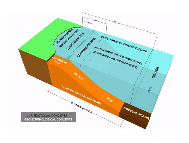
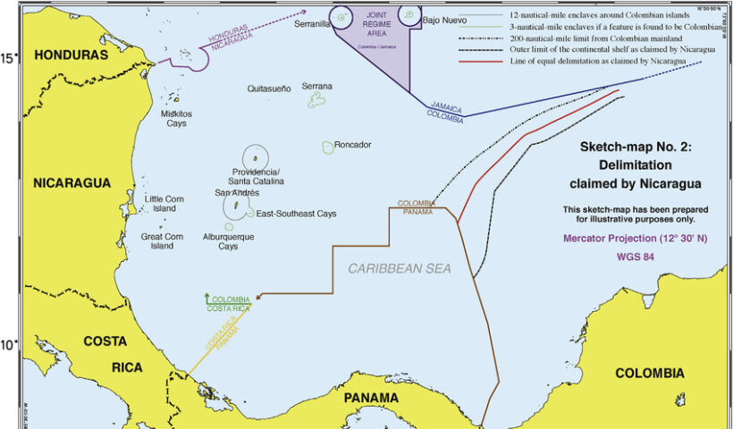
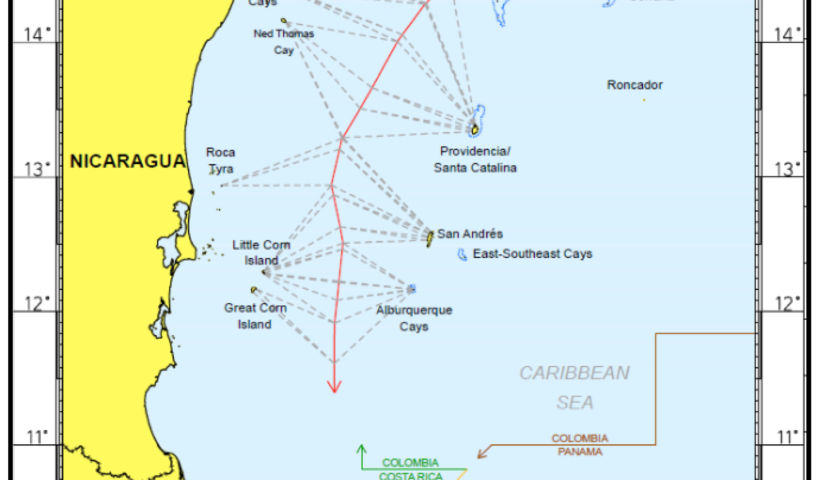
DEVELOPMENT OF CASE LAW RELATING TO MARITIME DELIMITATION, 1977 Anglo-French Continental Shelf case, an equitable result, Bangladesh/India Arbitration, Bangladesh/Myanmar case, Black Sea case, Cameroon/Nigeria case, continental shelf, corrective-equity approach, EEZ, equidistance method, equidistance/relevant circumstances method, equitable criteria, Equitable Principles, equitable result, Eritrea/Yemen Arbitration, Ghana/Côte d’Ivoire case, Greenland/Jan Mayen case, Gulf of Maine case, Guyana/Suriname Arbitration, maritime delimitation, Nicaragua/Honduras case, North Sea Continental Shelf judgment, Pierre and Miquelon Arbitration, provisional delimitation line, Qatar/Bahrain case, relevant circumstances, resultorientated equity approach, single combined equidistance–special circumstances rule, special circumstances, test of disproportionality, three-stage approach to maritime delimitations, Tunisia/Libya case, What are the stages of maritime boundary?, What is a single maritime boundary?, What is delimited boundary?, What is maritime space?, What is median line principle?, What is the difference between demarcation and delimitation?, Which law delimits world seas?

View More DEVELOPMENT OF CASE LAW RELATING TO MARITIME DELIMITATION

TREATY LAW CONCERNING MARITIME DELIMITATION

TREATY LAW CONCERNING MARITIME DELIMITATION, 1958 Convention on the Continental Shelf, 1977 Anglo-French Continental Shelf case, continental shelf, Delimitation of the contiguous zone, delimitation of the territorial seas, determining the applicable law, EEZ, equidistance (median line), Equitable Principles, equitable solution, inequitable results, LOSC, method of delimitation, special circumstances, TSC, What are the stages of maritime boundary?, What is a single maritime boundary?, What is delimited boundary?, What is maritime space?, What is median line principle?, What is the difference between demarcation and delimitation?, Which law delimits world seas?

View More TREATY LAW CONCERNING MARITIME DELIMITATION

CONCEPT OF MARITIME DELIMITATION in law of the sea and customary international law

CONCEPT OF MARITIME DELIMITATION in law of the sea and customary international law, coastal State jurisdiction over maritime space, delimitation of internal waters, Delimitation of the contiguous zone, Delimitation of the Continental Shelf, Delimitation of the EEZ, Delimitation of the territorial sea, Gulf of Maine case, maritime delimitation, maritime limits, maritime spaces, process of establishing lines, What are the stages of maritime boundary?, What is a single maritime boundary?, What is delimited boundary?, What is maritime space?, What is median line principle?, Which law delimits world seas?

View More CONCEPT OF MARITIME DELIMITATION in law of the sea and customary international law

what is the Main Issues of Maritime Delimitation in law of the sea and customary international law?

what is the Main Issues of Maritime Delimitation in law of the sea and customary international law?, advantages and disadvantages of the basic approaches to the law of maritime delimitations, approaches adopted by international courts and tribunals with regard to maritime delimitations, Main Issues of Maritime Delimitation, marine spaces, maritime delimitation, multiple jurisdictional zones, principal relevant circumstances in the law of maritime delimitation, principle applicable to maritime delimitations, role of international courts and tribunals in the development of the law of maritime delimitations, What are the stages of maritime boundary?, What is a single maritime boundary?, What is delimited boundary?, What is maritime space?, What is median line principle?, Which law delimits world seas?

View More what is the Main Issues of Maritime Delimitation in law of the sea and customary international law?

what is the meaning of Historic Bays on tle law of the sea and LOSC

The TSC and the LOSC contain no definition of historic bays. According to the Annex VII Arbitral Tribunal in the South China Sea Arbitration (Merits), a ‘historic bay’ is ‘a bay in which a State claims historic waters’. As historic bays are one of the categories of ‘historic waters’, the legal regime of historic bays should be examined in the broad context of historic waters. According to the ICJ, ‘historic waters’ usually mean ‘waters which are treated as internal waters but which would not have that character were it not for the existence of [a] historic title’.. what is the meaning of Historic Bays on tle law of the sea and LOSC, Concept of Historic Waters, geographical sense, Gulf of Sert, Historic Bays, historic rights, historic waters, ICJ, law of the sea, LOSC, Tunisia/Libya case

View More what is the meaning of Historic Bays on tle law of the sea and LOSC

Equitable Principles & the Delimitation of the Continental Shelf

Equitable Principles & the Delimitation of the Continental Shelf, Delimitation of the Continental Shelf, delimitation of the maritime boundary, Equitable Principles, International Court of the Justice, What are the characteristics of the continental shelf?, What does continental slope mean?, What extended continental shelf?, What is continental shelf limit?, What is the importance of continental shelf?, What is the largest continental shelf?, Where is the continental shelf?

View More Equitable Principles & the Delimitation of the Continental Shelf