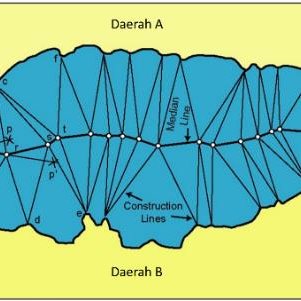
The selection of baseline or base points is fundamental to draw a provisional equidistance line. In this regard, one question to arise is whether the same baselines or base points for measuring limits of maritime zones should be used for the purpose of maritime delimitations.
Article 15 of the LOSC as well as Article 6 of the Geneva Convention on the Continental Shelf seem to suggest that when applying the equidistance method to maritime delimitations, an equidistance line should be, in principle, drawn from the baselines of the territorial sea. Nonetheless, the practice of international courts appears to demonstrate that where the use of the baseline or base points established by the Parties may produce an inequitable result, international courts and tribunals may select, within their compass, relevant base points for the purpose of maritime delimitations. Four cases merit particular attention.
First, in the Libya/Malta case, the validity of straight baselines for Malta was at issue. Under the Territorial Waters and Contiguous Zone Act, adopted on 7 December 1971, Malta established straight baselines. Although the ICJ refrained from expressing any opinion on the legality of the Maltese baselines, the Court considered it equitable not to take account of Filfla in the calculation. The Court thus pronounced that ‘the baselines as determined by coastal States are not per se identical with the points chosen on a coast to make it possible to calculate the area of the continental shelf appertaining to that State’.
Second, in the Eritrea/Yemen case (the Second Phase), the validity of Eritrea’s baseline was discussed. In Eritrean domestic law, enacted by Ethiopia in 1953, its territorial sea is defined as extending from the extremity of the seaboard at maximum annual high tide.
Nevertheless, the Arbitral Tribunal took the view that the median line boundary was to be measured from the low-water line in conformity with Article 5 of the LOSC because both Parties had agreed that the Tribunal was to take into account the provisions of that Convention. Further to this, Eritrea integrated a marine feature called the ‘Negileh Rock’ into its straight-baselines system. However, the Arbitral Tribunal did not admit the use of this marine feature as a base point and decided that the western base points to be employed on this part of the Eritrean coast should be on the low-water line of certain of the outer Dahlak islets, Mojeidi, and an unnamed islet east of Dahret Segala.
Third, in the Qatar/Bahrain case, Bahrain contended that, as a multiple-island State characterized by a cluster of islands off the coast of its main islands, it was entitled to draw a line connecting the outermost islands and low-tide elevations. Nonetheless, the Court ruled that Bahrain was not entitled to apply the method of straight baselines. Fourth, and importantly, the ICJ, in the Black Sea case, clearly distinguished the baseline for measuring the seaward breadth of marine spaces from the baseline for the purpose of maritime delimitations, by stating:
The Court observes that the issue of determining the baseline for the purpose of measuring the breadth of the continental shelf and the exclusive economic zone and the issue of identifying base points for drawing an equidistance/median line for the purpose of delimiting the continental shelf and the exclusive economic zone between adjacent/opposite States are two different issues.
The judicial examination of baselines or base points in the context of maritime delimitations may contribute to prevent an inequitable result arising from the liberal application of straight baselines.
In State practice, a question arises in cases where the validity of straight baselines established by one party is disputed by the other party. In these cases, some treaties gave only half (or partial) effect to the contested straight baselines. A case in point is the 1984 Agreement between Denmark and Sweden establishing a single maritime boundary.
Both countries established straight baselines, and, as a general rule, their straight baselines were used to compute the delimitation line. In the Baltic, however, Denmark objected to Sweden’s basepoint of Falsterborev. In the Southern Kattegat, Sweden objected to a Danish baseline connecting Hesselo with Sjoelland. In both instances, the Parties agreed to split in half the area generated by those baselines. The half-effect solution concerning straight baselines was also adopted in the 1975 Agreement between Italy and Yugoslavia and the 1977 Maritime Boundary Agreement between the United States and Cuba. The half or partial effect given to straight baselines seems to offer a solution when the validity of these baselines is disputed.

