of lists of geographical coordinates (archipelagic basepoints)
Jamaica’s Archipelagic Claim
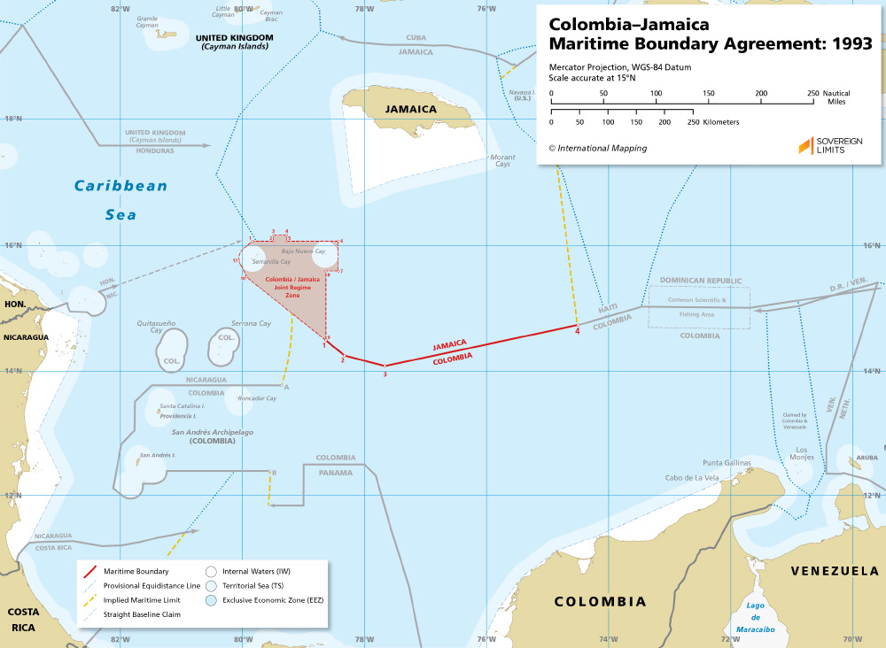
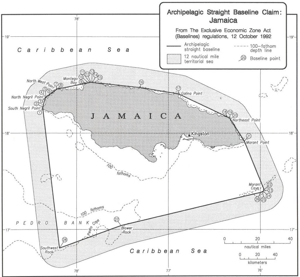
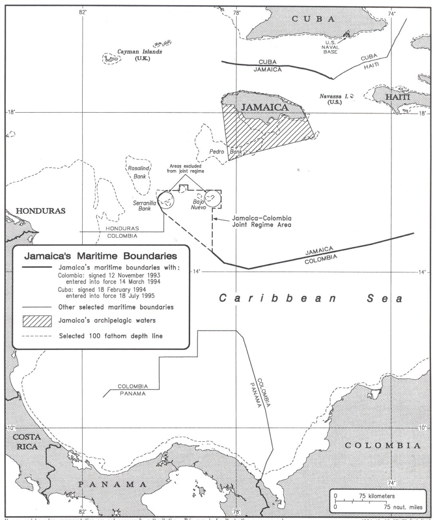
Archipelagic straight baselines: Jamaica’s archipelagic straight baselines have been plotted on, and on which this analysis is based, U.S. NGA chart 26120. The archipelagic baseline system is depicted on the attached page-sized map for illustration purposes only. Jamaica is comprised of one main island and about a half dozen small rocks, islets and cays generally situated about 60 miles south of the main island. Archipelagic straight baselines connect the main island to a rock, Southwest Rock and to a series of small cays, Morant Cays. Morant Cays and Southwest Rock are, in turn, connected by straight lines to Blower Rock. While Jamaica may not be the model archipelagic State the negotiators had in mind when they developed the archipelagic legal regime during UNCLOS III, it nevertheless meets the criteria set forth in Part IV of the Convention. The archipelagic straight baseline lengths range from 0.04 miles (segment 7-8) to 89.56 miles (segment 26-27). Nineteen of the 28 baseline segments are less than 8 miles in length. The longest segments are those that connect the main island to the small Morant Cays, Blower Rock, and Southwest Rock (see map at the end of the study). All baseline segments are within the LOS Convention permissible range. Jamaica would not qualify as an archipelagic State if they did not include the small southern rocks and cays in its archipelagic straight baseline system; in other words, the large main island of Jamaica by itself would not meet the archipelagic criteria.
Jamaica has a land area of approximately 10,990 square kilometers and the area of archipelagic waters is approximately 22,200 square kilometers. Thus, the land: water ratio created by the claimed archipelagic straight baselines is 1: 2.00, which is within the acceptable 1: 1 and 1: 9 land: water ratio cited in the LOS Convention.
An interesting issue that arises when one analyzes the Jamaican archipelagic straight baseline system is the role that rocks play in determining whether Jamaica is an archipelagic State. In the south, several of the basepoints are situated on very small features, features that could possibly qualify as Article 121 (3) “rocks”. Article 121 (3) states that;
“Rocks which cannot sustain human habitation or economic life of their own
shall have no exclusive economic zone or continental shelf.”
While no definition has been given as to what is meant by the ability to “sustain human habitation or economic life of their own”, it is quite possible the negotiators of the LOS Convention intended for this article to apply to features such as those found in the southern waters of Jamaica. However, whereas States do not enjoy the right to claim an exclusive economic zone or continental shelf from an Article 121 (3) rock, there is no provision in the LOS Convention limiting such claims if these same features form a part of the archipelagic baseline system.
Due publicity: In accordance with Article 47 (9) of the LOS Convention, the archipelagic State shall give due publicity to the charts or lists of geographical co-ordinates and shall deposit such charts or lists with the Secretary-General of the United Nations.
In 1996 Jamaica fulfilled this requirement when it deposited with the United Nations its The Exclusive Economic Zone Act (Baselines) regulations, 12 October 1992, which the United Nations has published in its Law of Sea Bulletin No. 32, 1996 (page 41). This October 1992 regulation mentions that official charts have been signed by the Minister and which shall be deposited and displayed at the Survey Department. No charts have been specified nor have any been deposited with the United Nations.
Navigation rights: Within archipelagic waters ships of all States have certain navigation rights. Subject to various provisions of the LOS Convention, ships enjoy the right of innocent passage through the archipelagic waters. The archipelagic State can, without discrimination among foreign ships, suspend temporarily in specified areas of the archipelagic waters innocent passage if such suspension is essential for the protection of its security (Article 52, LOS Convention). Within certain areas of the archipelagic waters foreign ships enjoy archipelagic sea lanes passage. According to Article 53 (1), “ an archipelagic State may designate sea lanes and air routes thereabove, suitable for the continuous and expeditious passage of foreign ships and aircraft through or over its archipelagic waters and the adjacent territorial sea.” This archipelagic sea lanes passage allows ships to transit in their “normal mode”, meaning e.g., submarines can transit submerged and naval battle groups may transit in a way that afford them the normal protection they would have in any body of water. If an archipelagic State designates archipelagic sea lanes they must abide by certain criteria set forth in Article 53, which includes referring proposals for such sea lane designation to “the competent international organization”, which would be the International Maritime Organization, based in London. If an archipelagic State does not designate archipelagic sea lanes, then archipelagic sea lanes passage “may be exercised through the routes normally used for international navigation.” (Article 43(12)).