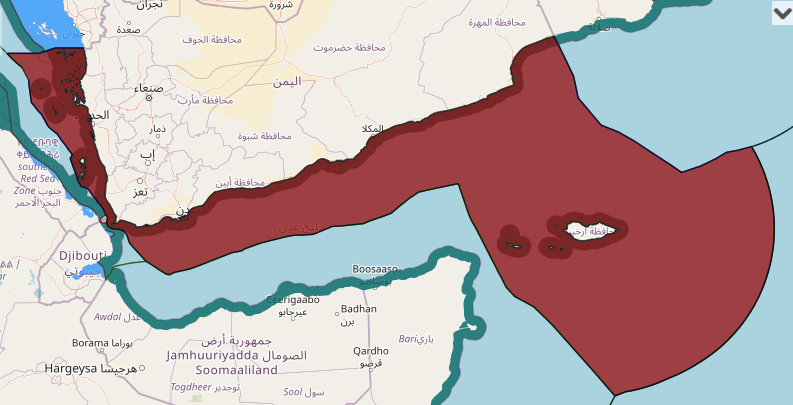
a list of geographical coordinates of points concerning the baselines for measuring the breadth of the territorial sea of the Republic of Yemen.


Post Views: 5,105
Related posts:
- Bangladesh claims for straight baselines in measuring the breadth of the territorial sea
- Republic of Korea maritime claims about baselines for measuring the breadth of the territorial sea
- Romania maritime claim about drawing of straight baselines and the outer limit of its territorial sea
- Norway maritime claims about drawing the baselines for measuring the width of the territorial sea around Svalbard
- Brazil claims on the Baselines for measuring the breadth of the territorial sea and Outer limit of the Exclusive Economic Zone
- Republic of Congo claims on baselines for measuring the breadth of the territorial sea, contiguous zone and exclusive economic zone
- Madagascar maritime claims about baselines(Straight) from which the breadth of the territorial sea
- New Zealand maritime claims about baselines from which the breadth of the territorial sea and maritime boundary delimited between New Zealand and Australia
- Australia territorial sea claims(baselines for measuring the breadth of the territorial sea)
- Nicaragua maritime claims about points concerning the baselines from which the breadth of the territorial sea
- Myanmar maritime claims about straight baselines for the Preparis and CoCo Islands, as contained in the Law Amending the Territorial Sea and Maritime Zones Law
- Iraq maritime claim about baseline of the territorial sea
- Cyprus claim about straight baselines
- Gabon maritime claim about straight baselines
- Honduras maritime claim about straight baselines
- India claim about points defining the baselines of India (straight baseline)
- Japan maritime claims about straight baselines and outer limits of the territorial sea
- charts (straight baselines and outer limits of the EEZ) and lists of geographical coordinates (straight baselines)of Argentina
- Finland claims about straight baselines and outer limits of the territorial sea
- Nicaragua maritime claims about straight baselines
- Pakistan maritime claims for the drawing of the straight baselines
- Uruguay maritime claims about straight baselines and the outer limit of the territorial sea, the contiguous zone and the exclusive economic zone
- Panama maritime claim about baselines
- Tanzania maritime claims about straight baselines
- Lithuania maritime claims about straight baselines as well as the outer limits of the territorial sea, the contiguous zone, the exclusive economic zone and the continental shelf
- Norway maritime claims about outer limits of the territorial sea around Bouvet island
- Tunisia maritime claims about drawing of straight baselines
- charts showing normal and straight baselines, the territorial sea, the contiguous zone, the exclusive economic zone and the continental shelf of Chile
- Ireland maritime claim about outer limits of the exclusive economic zone and outer limits of its continental shelf beyond 200 nautical miles from the baselines of territorial sea
- Sudan maritime claims about straight baseline in the Red Sea
- Norway maritime claims about outer limits of the territorial sea around mainland Norway, Svalbard and Jan Mayen and extent of the territorial sea around mainland Norway(2003)
- Kuwait maritime claims about baseline, territorial sea, exclusive economic zone and continental shelf
- Kenya maritime claims about straight baselines and outer limits of the exclusive economic zone
- Italy maritime claims about baselines, internal waters, territorial waters, exclusive economic zone and continental shelf(between former Yugoslavia, Tunisia, Greece, Albania and in Mediterranean sea, Adriatic sea, Ionian sea, tyrrhenian sea and Sardinia)
- Indonesia maritime claim about Archipelagic Baselines
- Myanmar maritime claims about Territorial Sea and Maritime Zones
- Qatar maritime claim about bay closing lines
- Fiji claims on the straight baselines
- United Arab Emirates maritime claims about Straight Baselines System in Persian Gulf
- chart showing the maritime boundary between Argentina and Chile, with the list of geographical coordinates of points

