charts concerning straight baselines and outer limits of the territorial sea and of a list of geographical coordinates of points as contained in the Enforcement Order of the Law on the Territorial Sea and the Contiguous Zone (Cabinet Order No. 210 of 1977, as amended by Cabinet Order No. 383 of 1993, Cabinet Order No. 206 of 1996 and Cabinet Order No.434 of 2001
List of deposited charts to UN
- Chart No. W3 – “Hokkaido and Approaches“, Scale 1:1,200,000
- Chart No. W10 – “Tsugaru Kaikyo“, Scale 1:250,000
- Chart No. W11 – “Shakotan Misaki to Matsumae Ko“, Scale 1:250,000
- Chart No. W28 – “Mashike Ko to Iwanai Ko“, Scale 1:200,000
- Chart No. W42 – “Kunashiri To and Approaches“, Scale 1:300,000
- Chart No. W45 – “Etorofu To“, Scale 1:300,000
- Chart No. W48 – “Nanpo Shoto“, Scale 1:2,500,000
- Chart No. W51 – “Izu Shoto“, Scale 1:150,000
- Chart No. W53 – “Miyako Ko to Shiriya Saki“, Scale 1:250,000
- Chart No. W54 – “Ishinomaki Wan to Miyako Ko“, Scale 1:200,000
- Chart No. W70 – “Omae Saki to Ise Wan“, Scale 1:200,000
- Chart No. W77 – “Kii Suido and Approaches“, Scale 1:200,000
- Chart No. W80 – “Nojima Saki to Omae Saki“, Scale 1:200,000
- Chart No. W87 – “Tokyo Wan to Inubo Saki“, Scale 1:200,000
- Chart No. W93 – “Daio Saki to Shio-No-Misaki“, Scale 1:200,000
- Chart No. W108 – “Muroto Saki to Ashizuri Misaki“, Scale 1:200,000
- Chart No. W120 – “Noto Hanto and Approaches“, Scale 1:200,000
- Chart No. W139 – “Tottori Ko to Fukui Ko“, Scale 1:200,000
- Chart No. W145 – “Niigata Ko to Oga Hanto“, Scale 1:250,000
- Chart No. W146 – “Suzu Misaki to Nyudo Saki“, Scale 1:500,000
- Chart No. W149 – “Tsuno Shima to Taisha Ko“, Scale 1:200,000
- Chart No. W159 – “Hi-No-Misaki to Suzu Misaki“, Scale 1:500,000
- Chart No. W162 – “Western Part of Japan Sea“, Scale 1:1,200,000
- Chart No. W179 – “Kanmon Kaikyo to Hirado Seto“, Scale 1:200,000
- Chart No. W182A – “Kagoshima Wan to Amami-O Shima“, Scale 1:500,000
- Chart No. W182B – “Amami-O Shima to Okinawa Shima“, Scale 1:500,000
- Chart No. W187 – “Northwestern Part of Kyushu“, Scale 1:300,000
- Chart No. W196 – “Kanmon Kaikyo to Busan Hang“, Scale 1:250,000
- Chart No. W210 – “Nagasaki to Xiamen“, Scale 1:1,500,000
- Chart No. W213 – “Hirado Shima to Koshikijima Retto“, Scale 1:200,000
- Chart No. W225 – “Approaches to Amami-O Shima“, Scale 1:125,000
- Chart No. W226 – “Okinawa Gunto“, Scale 1:200,000
- Chart No. W1009 – “Nippon and the Adjacent Seas“, Scale 1:3,500,000
- Chart No. W1030 – “East Entrance of Tsugaru Kaikyo to Erimo Misaki“, Scale 1:250,000
- Chart No. W1032 – “Erimo Misaki to Ochiishi Misaki“, Scale 1:250,000
- Chart No. W1040 – “Soya Kaikyo“, Scale 1:200,000
- Chart No. W1045 – “Rishiri To to Mashike Ko“, Scale 1:200,000
- Chart No. W1070 – “Tokyo Wan to Kunashiri Suido“, Scale 1:1,200,000
- Chart No. W1072 – “Tokyo Wan to Kagoshima Wan“, Scale 1:1,200,000
- Chart No. W1098 – “Shioya Saki to Ishinomaki Wan“, Scale 1:200,000
- Chart No. W1154 – “Eastern Part of Japan Sea“, Scale 1:1,200,000
- Chart No. W1169 – “Fukui Ko to Wajima Ko“, Scale 1:200,000
- Chart No. W1172 – “Taisha Ko to Tottori Ko“, Scale 1:200,000
- Chart No. W1180 – “Sado Kaikyo and Approaches“, Scale 1:200,000
- Chart No. W1195 – “Oga Hanto to Hakodate Ko“, Scale 1:250,000
- Chart No. W1200 – “Tsushima Kaikyo and Approaches“, Scale 1:500,000
- Chart No. W1220 – “Ashizuri Misaki to Miyazaki Ko“, Scale 1:200,000
- Chart No. W1221 – “Eastern Part of Osumi Kaikyo and Approaches“, Scale 1:200,000
- Chart No. W1222 – “Western Part of Osumi Kaikyo and Approaches“, Scale 1:200,000
The United Nations Convention on the Law of the Sea (LOS Convention) reflects customary
international law for the principles that underlie the proper and legal establishment of
baselines. The rules for drawing baselines are contained in articles 5-11 and 13-14 of the
LOS Convention. Article 5 states that “except where otherwise provided in this
Convention, the normal baseline for measuring the breadth of the territorial sea is the lowwater line along the coast.” Paragraph 1 of article 7 is the paramount paragraph that establishes the geographical conditions that must be met should a coastal State elect to claim straight baselines in particular locations. This paragraph states that straight
baselines may be drawn only in two specific geographic situations, that is, (a) “in localities where the coastline is deeply indented and cut into”, or (b), “if there is a fringe of islands along the coast in its immediate vicinity”.
The purpose of authorizing the use of straight baselines is to allow the coastal State, at its
discretion, to enclose those waters which have, as a result of their close interrelationship
with the land, the character of internal waters. According to the LOS Convention, “the sea
areas lying within the lines must be sufficiently closely linked to the land domain to be
subject to the regime of internal waters”. By using straight baselines, a State may also
eliminate complex patterns, including enclaves, in its territorial sea, that would otherwise
result from the use of normal baselines.
A United Nations study stated that when determining whether “conditions apply which
would permit the use of straight baselines it is necessary to focus on the spirit as well as
the letter of the first paragraph of article 7″ (of the LOS Convention). And, as a noted geographer has stated, “proper straight baselines usually have a number of segments, each composed of several legs, interspersed with sections of the low-water mark of island and mainland coasts….The length of individual legs is short and the baseline is rarely more
than 24 nautical miles from an exposed coast”. Article 14 of the LOS Convention
acknowledges that a combination of methods is appropriate for determining the type of
baselines in particular areas: “The coastal State may determine baselines in turn by any of
the methods provided for in the foregoing articles to suit different conditions.”
Japan’s coastline in many locations does not meet the LOS Convention geographic
conditions required for applying straight baselines. And, for the most part, the waters
enclosed by the new straight baseline system do not have the close relationship with the
land, but rather reflect the characteristics of the territorial sea or high seas. In these areas it
would be appropriate to use the normal baseline, the low-water mark.
Neither the LOS Convention nor the Convention on the Territorial Sea and the Contiguous
Zone place a specific distance limit on the length of a straight baseline. However, several
analyses have suggested limits ranging from 24 to 48 miles.
The position of the United States is that as a general rule baseline segments should not exceed 24 miles. The following analysis supports 24 miles as the maximum baseline length:
The 24-mile maximum segment length is implied from a close reading of the relevant
articles of the LOS Convention. Article 7(1) speaks of the ‘immediate vicinity’ of the coast.
Article 7(3) states that ‘the sea areas lying within the line must be sufficiently closely linked
to the land domain to be subject to the regime of internal waters.’ In both of these
descriptions, the implication is strong that the waters to be internalized would otherwise be
part of the territorial sea. It is difficult to envision a situation where international waters
(beyond 12 miles from the appropriate low-water line) could be somehow ‘sufficiently
closely linked’ as to be subject to conversion to internal waters.
This implication is reinforced by article 8(2) which guarantees the right of innocent passage
in areas converted to internal waters by straight baselines. Innocent passage is a regime
applicable to the territorial sea (with a maximum breadth of 12 miles). Preservation of
innocent passage carries over pre-existing rights in waters that were territorial in nature
before the application of straight baselines. Given this theme of linkage to territorial
waters, it follows that, as a rule, no straight baseline segment should exceed 24 miles.
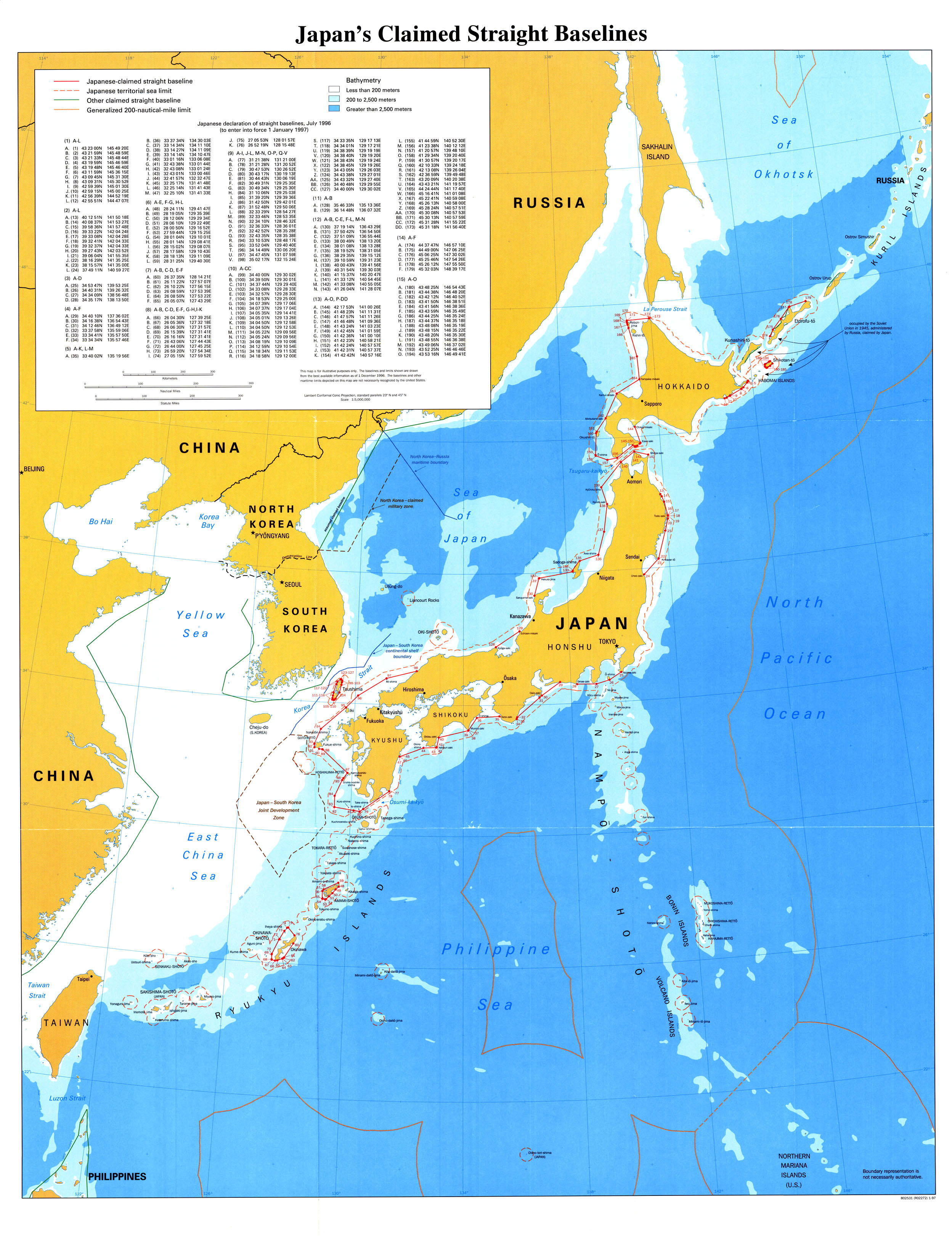
Japan has created 15 “groupings” of straight baselines that have been drawn along the
coasts of several of its islands. In all, there are 162 straight baseline segments that range
in length from 0.09 miles to 85.2 miles. Of these 162 baseline segments,
about 72 per cent are less than 24 miles in length. But, the remaining 28 per cent exceed
24 miles, with over 10 percent of the baselines longer than 48 miles.
The following analysis was conducted using Operational Navigational Charts (ONC, which
are Lambert Conformal Conic projection charts with a scale of 1:1,000,000). In the
creation of its 15 straight baseline groupings Japan has not developed a continuous
numbering system, but rather has assigned a new numbering system for each group. For
the purpose of this analysis, an additional numbering reference system has been created,
and applied on the large map found at the end of this study. In the analysis which follows
the numbers as they appear on the attached map are indicate in parentheses.
Generally, the coastal geography of the Japanese islands along which the straight
baselines have been drawn do not conform to the requirements called for in article 7,
paragraph 1 of the LOS Convention. For the most part, the coastlines of these Japanese
islands are neither “deeply indented and cut into”, nor is there a “fringe of islands” in the
immediate vicinity. In several situations, which will be noted in the following specific
analysis, article 10 “juridical” bay closing lines may be implemented for certain areas
landward of the claimed straight baselines. And, in many areas the excessive straight
baseline segment does not significantly alter the position of the outer limit of the territorial
sea from what would result from using the low-water mark.
Group 1: The group consists of 12 basepoints and 11 straight baseline segments along
the east coast of Hokkaido (points 1-12 on the attached large map). The coastline here is
relatively smooth, with no deep indentations. Point F (point 6) is situated on the small
island of Yururi-to, which is surrounded by a couple of smaller islets. But these small
features can not be considered “fringing islands”. Segments J-K and K-L (points 10-11
and 11-12 on the large map) do close an article 10 juridical bay. The remaining part of this
coast should have the low-water mark as the baseline. From Point L (pt. 12), which is situated on the southwestern entrance to Akkeshi-wan, to the town of Muroran, along the southwest coast of Hokkaido, the baseline is the low-water mark. This includes about 225 miles of coastline. For the straight baselines beginning at
Muroran, see Group 13 below.
Group 2: This grouping consists of 12 base points connecting 11 straight segments
along the northeast coastline of Honshu. These points are labeled 13-24 on the attached
large map. Segment A-B (13-14) is a short (4.9 miles) juridical bay closing line across Kuji
Bay. Segment B-C, 10.5 miles in length, improperly encloses a slightly indented coastline
that does not meet the article 10 bay closing requirements. Segment C-D, over 25 miles
long is situated along a coast that has one small deep indentation near the city of Miyako
which could have a 2.5 mile closing line, but which otherwise should have its territorial sea
measured from the low water line.
Segments D-E, E-F, and F-G (16-17, 17-18, and 18-19) are three segments each of which
is less than 0.5 miles long which merely connect points around a peninsula to the northeast
of the town of Yamada. These straight lines are drawn in an area that does not meet the
standards set forth in article 7 of the LOS Convention and should not be drawn.
Segment G-H (19-20) is a 4.9 mile line which closes an article 10 bay. The coastline
behind segment H-I (20-21, 22.6 miles in length) is deeply indented and represents the
type of coastline where a straight baseline can properly be used. The coastline between
Points I and J (points 21 and 22 on the large map) also is “deeply indented and cut into”.
However, the segment is improperly drawn. First, the segment distance is excessively long
at 52 miles and it encloses waters that are not “sufficiently closely linked to the land domain
to be subject to the regime of internal waters.” Point J is situated on an isolated island,
Kinkazan-to. Straight baselines could be justified closer to the mainland connecting the
respective headlands of the deep indentations.
Segment J-K (22-23) is a short segment on Kinkazan-to which does not meet LOS
requirements. The final segment in this grouping, K-L (23-24), is a 38.8 mile line which
exceeds the provisions of Article 7. It encloses waters that should be territorial sea and
high seas. A short 3-mile bay closing line could be drawn across a body of water
immediately to the northeast of the city of Sendai.
Group 3: This grouping of four base points creates three segments which essentially
closes two juridical bays along the southern coast of Honshu. The length of the closing
lines, however, exceeds the maximum closing allowed under article 10 of the LOS
Convention. This area does not meet the requirements of the article 7 straight baselines,
as the coastline only has the two indentations of the bays, and only one main island. The first two segments A-B (25-26) and B-C (26-27) delimit Sagami Bay, the body of water leading to Yokohama and Tokyo. O-Shima Island sits in the mouth of the bay and causes the bay to have two entrances. A closing line properly can be extended to the island.
However, Point C is situated on the smaller island of Iro-zaki which is located outside the
bay. The closing line should extend from O-Shima Island to the peninsula near the town of
Shimoda. It should be noted that a string of small Japanese islands extend seaward
generally perpendicular to this bay. No attempt has been made to draw straight baselines
out to these islands and the territorial sea is correctly measured from the low water line of
the islands.
Segment C-D (27-28) encloses an overlarge bay (i.e., the bay closing exceeds the
maximum permitted length of 24 miles). Under article 10 (5) a “straight baseline of 24
nautical miles shall be drawn within the bay in such a manner as to enclose the maximum
area of water that is possible with a line of that length.”
Group 4: The five segments found in group 4 (pts. 29-34) are situated on the southern
coast of Honshu. As drawn they exceed the provisions of article 7. The coastline in this
area is neither fringed with islands nor deeply indented. The coastline at Point A (29), near
the town of Hamamatsu, is smooth. Approximately 30 miles to the southwest of Point A
there is a headland from which a 9-mile bay closing line could be drawn across Ise-Wan.
Segment B-C (30-31) merely cuts across a peninsula. And, segment C-D (31-32) extends
54.2 miles in front of coastline that has several small bays, but which is otherwise smooth.
Segments D-E (32-33) and E-F (33-34) appear to close off a double-mouth bay. It is
unclear, however, if the points themselves have been placed on the proper headlands.
Group 5: This group includes segments A to K (pts. 35-45) and L to M (pts. 46-47) which
connect the southern coast of Honshu (south of Osaka) to the islands of Shikoku and
Kyushu. The southern coast of Honshu, between Osaka and Hiroshima is fringed with
many islands, including the large island of Shikoku and the drawing of straight baselines in
this area generally is in accordance with the LOS Convention. However, two of the
segments, A-B (41.7 miles) and E-F (55.8 miles) have lengths that are excessive and
enclose sea areas that are not “sufficiently closely linked to the land domain to be subject
to the regime of internal waters.” An A-B segment in the vicinity of 33°55′ parallel of north
latitude would be more appropriate. And, there probably should not be a segment E-F; the
baseline along the southern coast of Shikoku should be the low-water line.
Segment J-K closes the southern entrance to the Bungo strait. Segment L-M is an
insignificant line (only 0.2 miles in length) which is drawn along a peninsula. An important issue pertaining to this group is the closure of the Bungo Strait. This is an international strait which, along with the Shimonoseki Strait, another international strait to the northwest (which separates Honshu and Kyushu), is used for international navigation.
As such, this area in and between these two international straits should be governed by
Part III of the LOS Convention on Straits Used by International Navigation.
Group 6: This group of nine segments encircles Amami-shoto and adjacent islands.
Segments A-B (48-49) and B-C (49-50) are situated off the relatively smooth east coast of
Amami-shoto and should not have been drawn. Point B appears to be on an isolated rock.
A small article 10 bay closing line could be drawn to the west of Point C, and another to the
north of Point D instead of segment C-D (50-51).
The coastline south of Amami-shoto is fringed with the smaller islands and islets and the
segments connecting D-E (51-52), F-G (53-54), H-I (55-56), I-J (56-57), and J-K (57-58)
reflect this fringe. From Point K, however, a straight baseline should be drawn due east
back to Amami-shoto rather than to Point L (59) almost 30 miles away on the northern tip of
Amami-shoto. The coastline landward of segment K-L is not deeply indented, nor are there
fringing islands off this part of the coast.
Group 7: This group of straight baselines has been drawn off the east coast of OkinawaJima. Segment A-B (pts. 60-61) is 30 miles long and is drawn in an area where the
coastline is not deeply indented nor are there fringing islands. There are fringing reefs just
north of pt. 61 and straight baselines may be proper from an area about 12 miles north of
pt. 61 to point F (pt. 65).
Group 8: These straight baselines are situated off the west coast of Okinawa-Jima. While
there are approximately 5 small islands over a distance of about 65 miles, they cannot be
considered a fringe of islands. The territorial sea should be measured from the low-water
line in this area.
Group 9: This group of straight baseline segments (connecting points 77-85, 86-88, 89-
90, 91-92, 93-98 on the attached large map) begins on the southeast coast of Kyushu
Island and connects various small islands situated off the southwest and west coast of
Kyushu. It is unclear why segment A-B has been established since it is only a 0.2 mile long
segment on a peninsula near the town of Honjo. Points C through H (79-84) are all situated
on very small islets or rocks, and these small features are spread over a distance of about
80 miles, plus the 57 miles between Point B, on the peninsula, to the island of Takeshima
(pt. 79). This area can not be considered fringed with islands “along the coast in its
immediate vicinity” and these segments should be considered excessive under the
provisions of the LOS Convention. Immediately to the west of point 78 there are two “wellmarked indentations” along the southern coast of Kyushu which could have article 10 bay closing lines. This part of the Japanese coastline forms the northern part of Osumi Strait and Japan has made special provisions for claiming its territorial sea in this strait.
Points I, J, and K (pts. 85-87) are situated on islands, labeled as Koshikijima-Retto on the
attached map, which extend at an approximately 45° angle of deviation from the general
direction of the coast. Although the LOS Convention is silent on this aspect of establishing
straight baselines, several studies have suggested that in order to meet the “immediate
vicinity” requirement there must be some consideration given to location of the islands
relative to the mainland.
Segment K-L (connecting points 87-88) is over 62 miles long and encloses waters that
should remain territorial sea and high seas, and not internal waters. The islands in the
vicinity of points L to R (88 to 94) could have straight baselines, but in a manner slightly
different from Japan’s claim. A straight line could be drawn from a location on Kyushu near
Nagaski to one of the islands to the northeast of pt. 88 which would be about 24 miles in
length. The straight baseline segments could then be placed around Goto Retto to Iki
island, and then back to the mainland. However, segment R-S (94-95) should not be used,
as the waters encompassed by that segment are not closely linked to the mainland.
Segments connecting S, T, U, and V (95 to 98) clearly exceed the provisions of the LOS
Convention. Points 96 to 97 are but islets and these segments are 60, 31, 61, and 57
miles long, respectively. In this area the low water line is the proper baseline from which to
measure the territorial sea.
Group 10: This group creates straight baselines around the entire island of Tsushima,
which divides the Korea Strait into the Eastern and Western Channel. For the most part
straight baselines are not warranted for this island. There are small article 10 bays near
segment B-C (100-101), on the west coast near Point R (116), and south of Point S (117).
There are several islands in the vicinity of Point F (104) that could be considered fringing
and straight baselines with a total length of about 5 miles could be drawn. Most of the
baseline segments, as listed in Annex II, are less than 0.5 miles in length and have virtually
no impact on the territorial sea limit, let alone establishing internal waters. The low-water
line should be used as the baseline for virtually the entire coastline in this area.
Group 11: This is one segment connecting Points A-B (128-129) which are 52 miles
apart. This line exceeds the provisions of article 7 as the coast is neither deeply indented
nor fringed with islands. Several small article 10 bays can be identified inside this segment that have closing lines less than 10 miles. The waters enclosed by this segment, however,
should remain either high seas or territorial sea.
Group 12: This group of straight baseline segments is situated off the northwest coast of
Honshu and consists of very long lines. Nine of the ten segments exceed 25 miles in length
with three of them greater than 50 miles. This part of Japan’s coast is rather smooth and is
not deeply indented, and has only one medium-sized island (Sadogashima) situated off it.
The waters enclosed by segments A-B (130-131), C-D-E (132-134), F-G-H-I-J-K (135-
140), are not “sufficiently closely linked to the land domain to be subject to the regime of
internal waters” (as called for in article 7.3 of the LOS Convention). An Article 10 bay,
located to the east of point 130, can be established.
An over-large juridical bay is situated at the northern tip of Honshu, fronting on the Tsugaru
Strait. Segment K-L (140-141), however, exceeds the maximum breadth of an Article 10
bay (24 miles). A revised closing line should be drawn in a manner which, according to
Article 10 (5), encloses “the maximum area of water that is possible with a line of that
length.” The coastline between Points M and N (142-143) is a mere curvature in the coast,
and should have as its baseline the low-water line.
Group 13: Beginning at the town of Muroran, along the southwest coast of Hokkaido, this
group consists of two sections: Points A-O (pts. 144-158 on the attached map) and Points
P-DD (pgs 159-173 on the attached map). The first section connects coastline points
along the southwestern corner of Hokkaido to the small island of O-Shima, almost 30 miles
west of Hokkaido’s southwest point (the town of Matsumae). Point 159 begins on the
northwest tip of O-Shima and continues along the west coast of Hokkaido to Hokkaido’s
northern point, with the basepoints situated either on the offshore islands or on peninsulas
of Hokkaido.
Segment A-B (144-145) closes an article 10 juridical bay. However, the closing line
exceeds the permissible 24 mile length. A line extending essentially due south from Point
144 would be approximately 24 miles long and would properly define Uchiura-wan. Points
B through L (145-155 in this grouping) all are situated on a peninsula near the city of
Hokadate and, with the exception of segment D-E (147-148 which is 5.8 miles long),
create segments less than 2 miles in length. There are no offshore islands and the
coastline is smooth. Straight baselines are not called for in this situation.
Segment L-M (connecting pts. 155-156) enclose a part of the southern Hokkaido coast that
broadly curves. An article 10 juridical bay can be defined immediately to the west of
Hokadate, but elsewhere the low-water mark should be used as the baseline.
From Points M to S (156 to 162) the straight baseline segments extend from the southwest
corner of Hokkaido Island to connect the isolated islands of Ko-jima, O-Shima, Okushiri-To,
and then back to the Hokkaido mainland at Sukki. Ko-jima and O-Shima, are situated approximately 12 miles and 27 miles, respectively, off Hokkaido. The baseline segment connecting the two islands is 22.4 miles long. A line almost 40 miles in length is used to connect O-Shima to Ikushiri-To, an island which is 10 miles off the coast of Hokkaido. The straight baseline segment from Okushiri-To back to the mainland of Hokkaido is about 30 miles long. Three islands, scattered in an area in such a manner that it takes 110 miles to connect the mainland to these three islands by 4 baselines, cannot be considered fringing
islands. The territorial sea should be measured from the low-water mark of each island
and from the Hokkaido mainland.
Baseline points S-T (162-163) enclose waters situated in front of a slightly curved coast
along the west coast of Hokkaido. There are no fringing islands, nor is this part of the
coast deeply indented. The next segment, T-U (163-164), can be considered as closing an
overlarge bay. This is a bay which meets the requirements of an article 10 bay, but the
closing line exceeds the maximum permissible length of 24 miles by more than twice the
distance. In such cases, paragraph 5 of this article states that:
a straight baseline of 24 nautical miles shall be drawn within the bay in such a
manner as to enclose the maximum area of water that is possible with a line of that
length.
The next two baseline segments, U-V (164-165) and V-W (165-166) connect the small
island of Teuri-jima to a point on Hokkaido, to the south, and with another island, Rebun-To
to the north. The two segments are 41.4 miles and 53.3 miles long, respectively. These
islands, even if one also considers Rishiri Shima–situated close to Rebun-To–are not
fringing islands. A series of baseline segments have been drawn along the coast of
Rebun–To (basepoints 166-171) which do not meet article 7 (1) criteria.
Finally, segment BB-CC (connecting points 171-172) connects Rebun–TO to the north
coast of Hokkaido. This 40.4 mile long line should not be drawn since it is not connecting
an island which fringes the coastline.
Group 14: This group of 5 straight baseline segments have been drawn along the northern
coast of Etorofu-to No straight baselineshave been claimed along the southern coast. There are no fringing islands situated off the north coast, nor is the coastline deeply indented. Segment A-B (13 miles in length) does
appear to meet the requirements of an article 10 “juridical” bay. But along the remaining
part of the coastline, the low-water line should be the baseline.
Group 15: This group of 14 straight baseline segments (points A-O; points 180-194 on the
large map) almost encloses Shikotan-to. This rectangular-shaped island is about 16 miles long and 6 miles wide with only a couple of small offshore islets. The length of these baseline segments range from 0.21 miles to about 7.8 miles. The coastline of the island is not deeply indented. With the exception of some small bay closing lines that could be
drawn, the proper baseline for this island would be the low-water line. The 12-mile territorial sea measured from the low-water mark would essentially be the same as that measured from the claimed straight baselines.
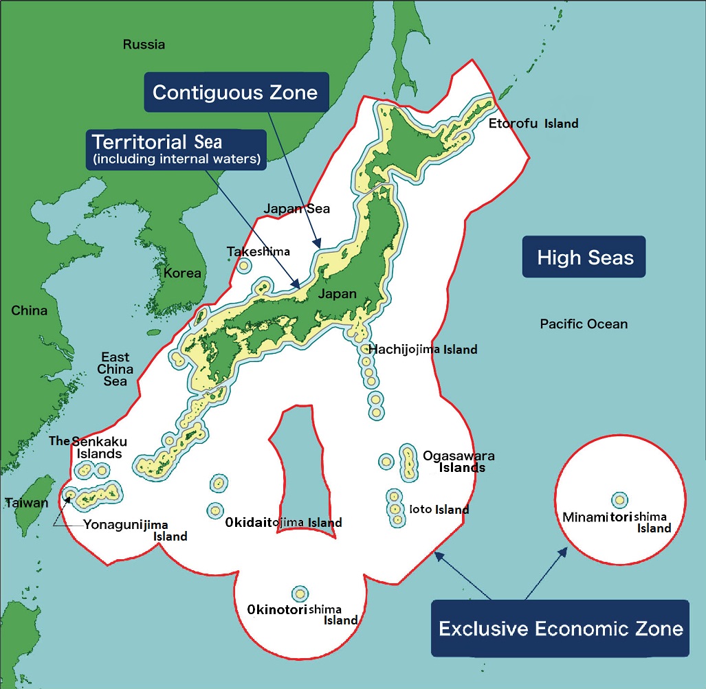
JAPAN’S TERRITORIAL SEA CLAIM
By Law No. 30 of 1977, Japan extended its territorial sea to 12 miles, except for specified
designated areas in five international straits in which it has developed specific definitions
which creates territorial sea limits between 3 and 12 miles. The five international straits
affected by this decision are the Eastern and Western Channels of the Tsushima Strait,
Osumi Strait, La Perouse (Soya Strait), and Tsugaru Strait. Japan has made its territorial
sea claim less than 12 miles in these straits to maintain high seas corridors.