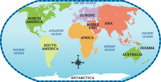
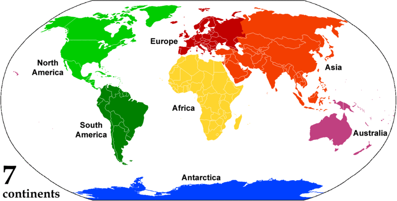
The seven continents that make up the world’s land mass are, from largest to smallest: Asia, Africa, North America, South America, Antarctica, Europe, and Australia. Only 29 percent of the Earth’s surface is land. The percentage area of each continent is shown here.
Highest point on Earth: Mt. Everest, China/Nepal, 29,035 ft (8,850 m). Lowest point on Earth: Mariana Trench, Pacific Ocean, 35,840 ft (10,924 m). Longest river: Nile, Egypt/Sudan/Uganda, 4,187 miles. Largest lake: Caspian Sea, Azerbaijan/Iran/Turkmenistan/ Kazakhstan/Russian Federation, 146,101 sq miles (378,400 sq km). Largest ocean: Pacific Ocean, 63,804,540 sq miles (165,241,000 sq km).
Africa is sometimes nicknamed the “Mother Continent” due to its being the oldest inhabited continent on Earth. Humans and human ancestors have lived in Africa for more than 5 million years. Africa, the second-largest continent, is bounded by the Mediterranean Sea, the Red Sea, the Indian Ocean, and the Atlantic Ocean.
MOVING CONTINENTS
THE CONTINENTS THAT MAKE UP most of the Earth’s land surface are always on the move, shifted around by forces deep inside the Earth. This is known as continental drift. Movement, or drift, takes place because of intense heat generated within the Earth.
The heat is carried upward where it disturbs the cool, rocky surface, or crust, forcing sections of it, called plates, to move. Each year the continents, parts of the plates, drift nearly half an inch (about a centimeter), some getting closer together, others moving farther apart, some grinding past each other. As this happens, many of the Earth’s natural features are created or changed.
In the beginning Scientists believe that some 300 million years ago all the land on Earth was joined together in one “supercontinent” called Pangaea. It was surrounded by a giant ocean, Panthalassa. About 200 million years ago, as the plates moved, Pangaea began to split into two great landmasses, Laurasia in the north, and Gondwanaland in the south. These were separated by the Tethys Sea. As the plates continued to move, the two landmasses split and moved farther apart, eventually forming the continents.
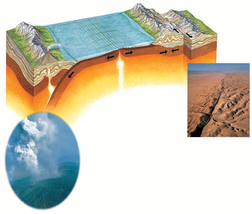
RESTLESS EARTH
Because the Earth appears to stand still, it is difficult to imagine that the crust is moving. In fact, its plates move in three main ways – as spreading ridges, subduction zones, and transform faults, all shown on the artwork below. It is possible to see the effect this activity has had on the landscape. The Rocky Mountains in North America were formed when two plates collided, while the Great Rift Valley in Africa is the result of plates pulling apart. Volcanoes and earthquakes are also dramatic reminders that the plates are moving.
SPREADING RIDGES
A spreading ridge occurs where two plates start to pull apart and molten rocks from the Earth’s mantle well up to fill the gap. If this happens along the ocean floor, it creates an underwater mountain chain such as the Mid-Atlantic Ridge. Sometimes the peaks of these mountains break the surface as volcanic islands, as happened with Iceland. When a spreading ridge occurs on land, it creates a steep-sided rift valley.
Earth has a total surface area of 510 million km²; 149 million km² (29.2%) are “dry land”; the rest of the planet’s surface is covered by water (70.8%).
Shortly after humans left the trees, 6 million years ago, they started naming their environment, Black Rock, Long Water, Dark Wood, Water Fall, Spring Field, Sea of Grass, Blue Mountain, Hippo Campus, etc.
Six million years later, they had named the whole planet. The continents were named last because mankind had no clue of the shape of the earth for a long time. The Age of Discovery, or the Age of Exploration, the serious search for information and resources began in the 15th century, when European explorers sailed and charted much of the rest of the world, for various reasons. By the beginning of the 20th century, most of the Earth’s surface had been explored, no more blank areas, except for the deep sea.
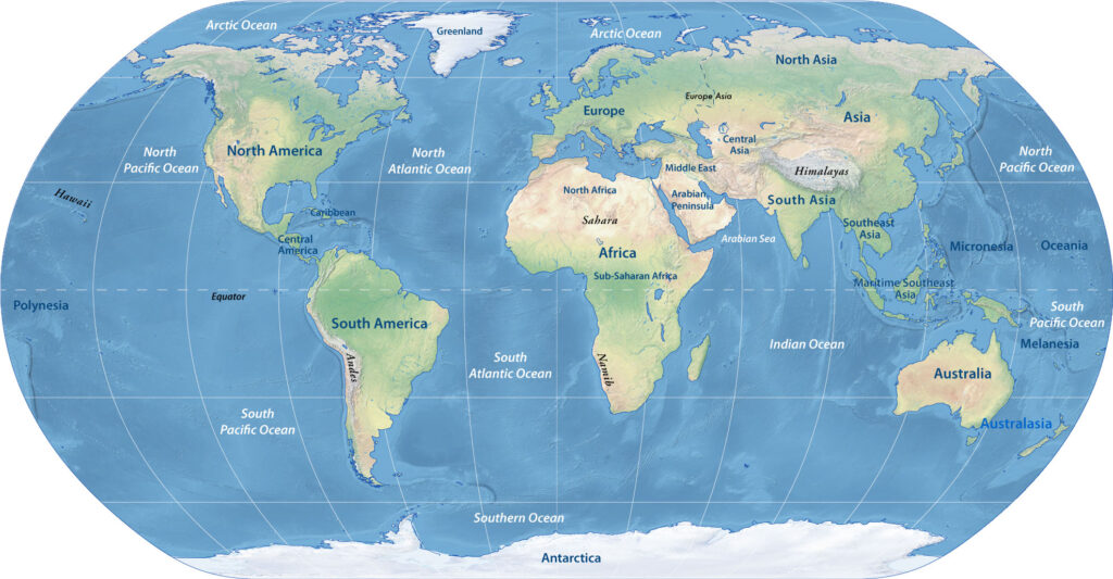
Eurasia
Eurasia is a single landmass and the largest continent on the planet. The supercontinent covers an area of about 51 million km². Most of the continent “sits” on the Eurasian tectonic plate, except for the Indian and Arab subcontinent, which have their own tectonic ride.
Eurasia is subdivided by convention into Asia and Europe, separated from each other by the Caspian Sea, the Ural River, and the Urals (the Ural Mountains).
The Ural mountain range runs from the coast of the Arctic Ocean southwards through the western part of Russia.
Africa
The second-largest landmass is the continent of Africa with an area of 30.2 million km². Africa, as we know it, is in reality the visible part of the African tectonic plate; the rest of the plate is under the waters of various oceans and seas around its landmass.
The continent is subdivided by convention into North(ern) Africa, West(ern) Africa, East(ern) Africa, Central Africa, and Southern Africa.
54 countries share the continent. 1,276 million people live in Africa.
The Americas
The Americas consist of the continents of North and South America, which are joined by the Isthmus of Panama (Central America), plus the islands of the Caribbean. North and South America are geologically separate continental masses.
North America
North America is Earth’s third-largest landmass, with an area of 24.2 million km². It is separated from mainland Asia (Russia’s Far East) by the 83 km (at the narrowest part) wide Bering Strait. However, a portion of eastern Russia (eastern Siberia) is, in reality, part of the North American plate.
Mainland North America is home to three countries, Canada, the United States, Mexico, and Greenland, the world’s largest island, which belongs geographically to North America.
Central America
North America is connected to South America by the Isthmus of Panama, a landbridge between the Caribbean Sea and the Pacific Ocean and home to seven countries: El Salvador, Costa Rica, Belize, Guatemala, Honduras, Nicaragua, and Panama.
South America
South America is located almost entirely in the Southern Hemisphere. It is bordered in the west by the Humboldt Current of the Pacific Ocean and in the east by the Brazil Current of the South Atlantic Ocean. With an area of 17.8 million km², it is number four in the shortlist of the largest continents.
The continent is situated on the South American Plate, which meets the Caribbean Plate in the Caribbean Sea in the north, the Nazca plate in the South Pacific Ocean in the west. It adjoins the African plate in the east, and it borders the Antarctic Plate in the south.
Australia
Australia is both, a country and a continent; it is the smallest in our hitlist of the largest continents. Australia’s landmass measures 7.6 million km²; it is smaller than the area of Europe with about 10.2 million km². Australia travels together with the island of New Guinea on the Australia tectonic plate.
Antarctica
Antarctica has a land area of 14.2 million km², making it the world’s fifth-largest continent. Somewhere in the middle of this vast, cold, and hostile continent is the South Pole, the southernmost point on the surface of the Earth. The southernmost continent is the hub for one of the two endpoints of Earth’s rotation axis. Antarctica has its own tectonic plate, named the Antarctic plate.
Oceania
Oceania isn’t a continent; it is a geographic region encompassing the islands of Micronesia, Melanesia, and Polynesia in the Pacific Ocean and the adjacent seas. For good measure, Australia and New Zealand are included in the Oceanian area.