Maritime conflicts between the United States and Canada have been a recurring issue, with disputes arising over various matters such as territorial claims, fishing rights, and boundary delimitation. These conflicts have tested the legal frameworks in place to manage maritime disputes, including the United Nations Convention on the Law of the Sea (UNCLOS) and bilateral agreements. Understanding the historical context and examining specific case studies can shed light on the root causes of these conflicts and provide insights into potential resolutions. This article aims to analyze the legal disputes in the law of the seas between the United States and Canada, exploring various aspects of these conflicts.
View More Examining US-Canada Maritime Conflicts: Analysis of Legal Disputes in the Law of the SeasTag: Canada maritime boundaries map
Analyzing Canada-Russia Maritime Disputes: A Law of the Seas Perspective
Canada and Russia have long been engaged in maritime disputes, with conflicting territorial claims and competing interests in the Arctic region. These disagreements have persisted for decades and have become increasingly significant as the potential for resource exploitation and shipping routes in the Arctic opens up. This article will analyze the Canada-Russia maritime disputes from a Law of the Seas perspective, examining the historical background, key areas of contention, legal frameworks, dispute resolution mechanisms, and environmental concerns. By understanding these issues, we can gain insights into the prospects for cooperation between the two countries.
View More Analyzing Canada-Russia Maritime Disputes: A Law of the Seas PerspectiveNavigating Maritime Law and Security in Canada
Canada has one of the world’s longest coastlines and a vast maritime domain, making maritime security and law an important part of the nation’s overall security. To understand how Canada is navigating its maritime law and security in the 21st century, it is important to consider the various regulations, challenges, and solutions that are implemented in the country. This article will explore the regulations, challenges, and modern solutions that are used to ensure the safety and security of Canadian waters.
View More Navigating Maritime Law and Security in CanadaExploring Canada’s Maritime Matters in Law of the Seas and Security
Canada is one of the world’s most important maritime nations, with the world’s longest coastline and the fourth largest exclusive economic zone. Canada’s maritime matters, which include the Law of the Seas, maritime security, and the impact of maritime activity, have a major impact on the country’s security, economy, and environment. Therefore, it is important to understand the scope and complexity of Canada’s maritime matters and to identify future directions for action in this area.
View More Exploring Canada’s Maritime Matters in Law of the Seas and Security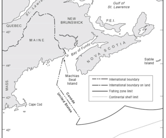
Canada–United States overlapping claims in North Atlantic and surrounding Machias Seal Island and North Rock
In 1979 the Canada and the United States agreed to empower a Chamber of the ICJ to designate a single seabed and water-column boundary in the Gulf of Maine. The Chamber’s 1984 Judgment establishes a segmented boundary that commences at an offshore point mutually agreed by both States (Point A) and terminates at the point of intersection with the United States’ 200 nautical mile limit. McDorman notes that, prior to the conclusion of the 1979 agreement, Canadian and US negotiators had proposed several options concerning provisional joint management of overlapping claims in the Gulf of Maine. These proposals did not gain traction because delimitation issues proved difficult to set aside. In particular, the location of competing boundary claims influenced political views concerning the fair division of fisheries and potential hydrocarbon resources.
View More Canada–United States overlapping claims in North Atlantic and surrounding Machias Seal Island and North Rock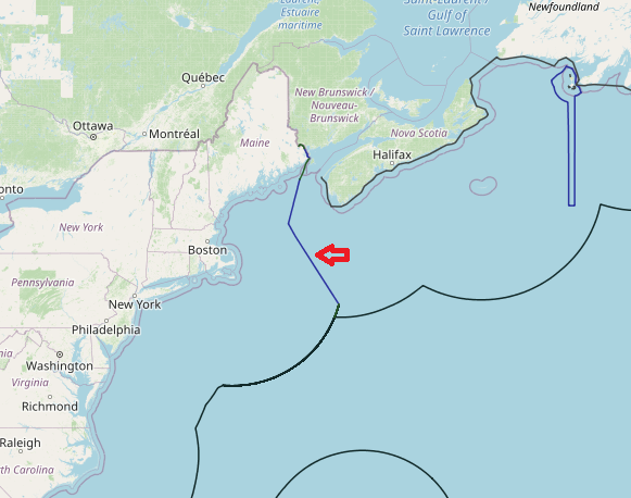
Maritime boundaries between United States of America and Canada(in Atlantic sea)
On 25 November 1981, Canada and the United States notified to the Court a Special Agreement whereby they referred to a Chamber of the Court the question of the delimitation of the maritime boundary dividing the continental shelf and fisheries zones of the two Parties in the Gulf of Maine area. This Chamber was constituted by an Order of 20 January 1982, and it was the first time that a case had been heard by an ad hoc Chamber of the Court.
View More Maritime boundaries between United States of America and Canada(in Atlantic sea)