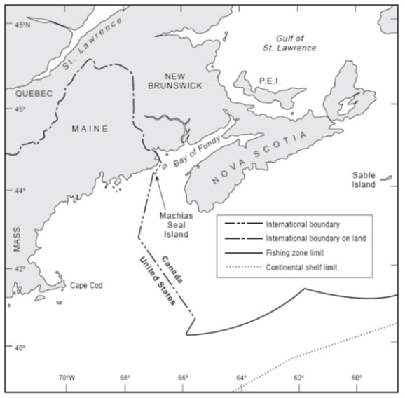
In 1979 the Canada and the United States agreed to empower a Chamber of the ICJ to designate a single seabed and water-column boundary in the Gulf of Maine. The Chamber’s 1984 Judgment establishes a segmented boundary that commences at an offshore point mutually agreed by both States (Point A) and terminates at the point of intersection with the United States’ 200 nautical mile limit. McDorman notes that, prior to the conclusion of the 1979 agreement, Canadian and US negotiators had proposed several options concerning provisional joint management of overlapping claims in the Gulf of Maine. These proposals did not gain traction because delimitation issues proved difficult to set aside. In particular, the location of competing boundary claims influenced political views concerning the fair division of fisheries and potential hydrocarbon resources.
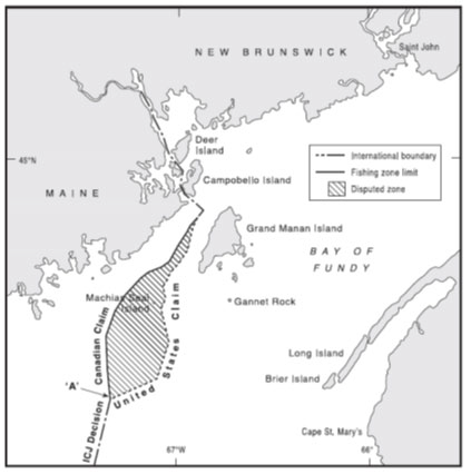
The 1984 Judgment did not delimit two areas that have remained subject to overlapping jurisdictional claims. The first OCA consists of waters located landward of Point A surrounding Machias Seal Island and North Rock (between Maine and Nova Scotia). These features are claimed by both States and Point A was chosen in order to separate territorial sovereignty-related issues from the maritime delimitation undertaken by the ICJ. The second OCA is located seaward of the terminal point of the boundary designated in the 1984 Judgment. This area is subject to overlapping continental shelf claims promulgated by both States. A sub-component of the OCA (commonly referred to as ‘the gray area’) is also subject to an EEZ claim promulgated by Canada.
Design features of provisional joint management frameworks:
Activity in the OCAs described above is managed in accordance with several functionally specific formal and informal cooperative arrangements. several government agencies from each State cooperate closely within their field of operational responsibility and have developed detailed cooperative management arrangements that apply to both OCAs and contiguous areas of nonoverlapping jurisdiction.
Enforcement jurisdiction in the OCAs is allocated by reference to the flag State of the vessel. As discussed in 3.2.1, Canada and the United States only exercise jurisdiction within OCAs over vessels flying their respective flags and law enforcement agencies of each State engage in regular consultations. There have been several attempts to harmonies the domestic regulations of both States concerning fisheries activities in the OCAs. Both States have adopted informal processes of technical and inter-agency communication in order to manage and allocate fish stocks in the Gulf of Maine and surrounding waters. A key measure in this context is the Transboundary Management and Guidance Committee, which recommends a total allowable catch for several species. Domestic regulations concerning lobster fishing in the OCA surrounding Machias Seal Island and North rock remain somewhat divergent. Hydrocarbon exploration and exploitation within the OCAs and surrounding waters is currently subject to moratoria established in accordance with domestic legal procedures in each State.
Comment concerning functional coverage:
The United States and Canada engage in cooperative management of their Atlantic OCAs in accordance with a complementary collection of international legal instruments, cooperative management arrangements developed by equivalent government agencies in each State, and coordinated national policy-making. When viewed in isolation, each of these frameworks exhibits functional gaps, focusing on a particular functional context or management challenge. However, the coherent application of the various frameworks establishes a functionally-broad allocation of coastal State jurisdiction within the relevant OCAs.