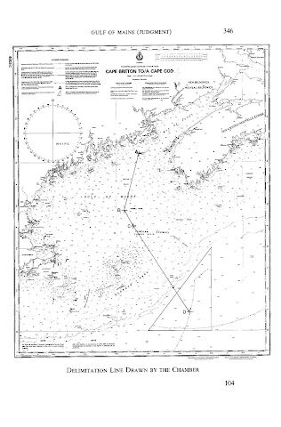
MARITIME SPACES IN international law of the sea are, in essence, defined in relation to the coastal State jurisdiction over each maritime space. Thus, coastal State jurisdiction is the primary criterion in characterising maritime spaces. The ambit of coastal State jurisdiction is in principle defined spatially, based on distance from the coast. According to the 1982 UN Convention on the Law of the Sea, the territorial sea in which a coastal State exercises territorial sovereignty shall not exceed 12 nautical miles measured from the relevant baseline (Article 3). The contiguous zone over which a limited jurisdiction is exercised by the coastal State may not extend beyond 24 nautical miles from that line (Article 33). The Exclusive Economic Zone (EEZ), where the coastal State may exercise sovereign rights regarding the exploration and exploitation of natural resources, shall not extend beyond 200 nautical miles (Article 57). The same is in principle true for continental shelves of less than 200 nautical miles (Article 76(1)). It would seem safe to say that these rules have now become customary law. Hence, the definition of the spatial extent of coastal State jurisdiction is at the heart of the international law of the sea.
View More Importance of Maritime Delimitation in International Law of the SeaTag: What is the principle of maritime delimitation?
what is the meaning of single maritime boundaries line (single line with dual purpose or all-purpose line)
In theory, the delimitation of the exclusive economic zone could follow a different line than the continental shelf. For practical reasons, however, states seem to have wanted to have their maritime zones delimited by a single maritime boundary for all purposes. The reason for this lies first of all in the shared overlap of natural resources between the two zones.
View More what is the meaning of single maritime boundaries line (single line with dual purpose or all-purpose line)Three-stage Approach of Maritime Delimitation in law of the sea (customary international law and court decisions)
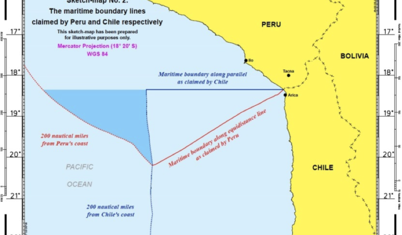
Three-stage Approach of Maritime Delimitation that the International Court of Justice (ICJ) “has developed a settled jurisprudence relating to the interpretation of those provisions”, while quoting the Court’s description of the three-stage approach of first drawing a provisional delimitation line, then assessing that line in the light of the relevant circumstances of the case and finally applying the disproportionality test to determine whether the proposed boundary results in an equitable solution, which has been developed in the context of the delimitation of the continental shelf and the exclusive economic zone. “international law thus calls for the application of an equidistance line, unless another line is required by special circumstances”. However, the assertion that the ICJ’s three-stage approach is settled jurisprudence in relation to article 15 is not borne out by a reading of the judgments. The quotation in paragraph 999 of the Award is from the judgment of the Court in Peru v. Chile. As the Award indicates, the Court in this connection makes reference to its earlier decisions in Black Sea and Territorial and Maritime Dispute (Nicaragua v. Colombia). All three decisions discuss the three-stage approach in relation to the delimitation of the exclusive economic zone and the continental shelf and there is nothing in these judgments suggesting that the Court considered that the three-stage approach applies equally to the delimitation of the territorial sea under article 15 of the Convention.
View More Three-stage Approach of Maritime Delimitation in law of the sea (customary international law and court decisions)Delimitation of the Maritime Boundaries between the adjacent States
Delimitation of the Maritime Boundaries between the adjacent Boundaries between the adjacent States , a PDF+PPT lecture by Nugzar Dundua, United Nations United Nations, The…
View More Delimitation of the Maritime Boundaries between the adjacent States


