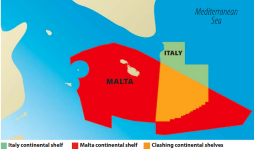
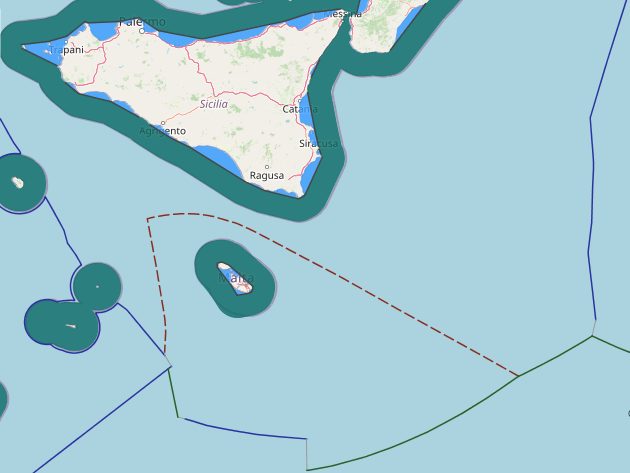
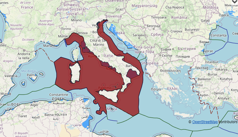
INFORMAL AGREEMENT BETWEEN ITALY, MALTA ON MORATORIUM OFFSHORE SICILY A new chapter has opened in the relations between Italy and Malta: Rome and Valletta agreed “informally” to suspend oil drilling in the Southeastern area of Sicily where the respective claims are overlapped.
The political commitment given by the two Countries allows to glimpse prospects for resolving their long standing dispute on the delimitation of the continental shelf (CS) as well as expresses the always excellent level of their bilateral relations. The agreement must be however followed by the formal delimitation of the maritime boundary. Moreover there is a third party concerned to be considered: Libya, whose continental shelf borders the hypothetical limits of both Italy and Malta’s CS.
Category: continental shelf claims
Denmark(Faroe Islands)–United Kingdom maritime boundary and Special Area
In May 1999 Denmark and the United Kingdom concluded an agreement (1999 Agreement) concerning their overlapping claims to fisheries zones and continental shelf in North Atlantic waters located between the Faroe Islands and Scotland. The 1999 Agreement designates continental shelf and fisheries zone boundaries in addition to a ‘Special Area’ of water column that remains subject to the overlapping jurisdictional claims both States.
View More Denmark(Faroe Islands)–United Kingdom maritime boundary and Special AreaColombia–Jamaica maritime boundary and the Joint Regime Area
In 1993 Colombia and Jamaica concluded a treaty (1993 Treaty) concerning their overlapping claims to a continental shelf and EEZ in the Caribbean Sea. Article 1 of the 1993 Treaty establishes a maritime boundary between the two States. Immediately to the west of the boundary, the 1993 Treaty also establishes a ‘Joint Regime Area’ in which, ‘pending the determination of the jurisdictional limits of each Party …, the Parties agree to establish … a zone of joint management, control, exploration and exploitation of living and non-living resources’. Article 3(1), sub-paragraphs (b) and (c) of the 1993 Treaty exclude two circular areas of 12 nautical miles radius from the Joint Regime Area. One circular area surrounds the cays of the Seranilla Bank and the other surrounds the cays of Bajo Nuevo. Both of these groups of features are claimed by Colombia – a claim that has been disputed on various occasions by Honduras, Jamaica, Nicaragua and the United States.
View More Colombia–Jamaica maritime boundary and the Joint Regime Areamaritime boundaries between Italy and Malta
maritime boundaries between Italy and Malta,
View More maritime boundaries between Italy and MaltaViet Nam maritime claims about Delimitation of the Territorial Sea, the Exclusive Economic Zone and Continental Shelf, such as in the Gulf of Tonkin with China
Maritime Claims, Viet Nam continental shelf map, Viet Nam EEZ map, Viet Nam exclusive economic zone map, Viet Nam internal waters map, Viet Nam maritime boundaries, Viet Nam maritime claims, Viet Nam territorial waters map
View More Viet Nam maritime claims about Delimitation of the Territorial Sea, the Exclusive Economic Zone and Continental Shelf, such as in the Gulf of Tonkin with ChinaUruguay maritime claims about straight baselines and the outer limit of the territorial sea, the contiguous zone and the exclusive economic zone
Maritime Claims, Uruguay, Uruguay continental shelf map, Uruguay EEZ map, Uruguay exclusive economic zone map, Uruguay internal waters map, Uruguay maritime boundaries, Uruguay maritime claims, Uruguay territorial waters map
View More Uruguay maritime claims about straight baselines and the outer limit of the territorial sea, the contiguous zone and the exclusive economic zoneUK maritime claims about outer limit of extended continental shelf and exclusive economic zone
Great Britain, Great Britain continental shelf map, Great Britain exclusive economic zone map, Great Britain internal and territorial waters map, Great Britain maritime claims, Maritime Claims, UK, UK continental shelf map, UK EEZ map, UK exclusive economic zone map, UK internal waters map, UK maritime boundaries, UK maritime claims, UK territorial waters map
View More UK maritime claims about outer limit of extended continental shelf and exclusive economic zoneSuriname maritime claims about outer limits of the continental shelf beyond 200 nautical miles
Maritime Claims, Suriname, Suriname continental shelf beyond 200 nautical miles, Suriname continental shelf map, Suriname EEZ map, Suriname exclusive economic zone map, Suriname internal waters map, Suriname maritime boundaries, Suriname maritime claims, Suriname maritime map and chart, Suriname territorial waters map
View More Suriname maritime claims about outer limits of the continental shelf beyond 200 nautical milesRussia maritime claims about the outer limits of its continental shelf beyond 200 nautical miles in respect to the Barents Sea
Barents Sea, Barents Sea continental shelf border, Barents Sea EEZ border, Barents Sea map, russia, Russia continental shelf map, Russia exclusive economic zone map, Russia internal waters map, Russia maritime boundaries, Russia maritime claims, Russia territorial waters map, russian federation
View More Russia maritime claims about the outer limits of its continental shelf beyond 200 nautical miles in respect to the Barents SeaRussia maritime claims about the area of the continental shelf beyond 200 nautical miles in the region of the Sea of Okhotsk
continental shelf beyond 200 nautical miles in the region of the Sea of Okhotsk, Maritime Claims, russia, Russia continental shelf map, Russia exclusive economic zone map, Russia internal waters map, Russia maritime boundaries, Russia maritime claims, Russia territorial waters map, russian federation, Sea of Okhotsk
View More Russia maritime claims about the area of the continental shelf beyond 200 nautical miles in the region of the Sea of OkhotskPhilippines maritime claim about changing the name “Benham Rise” to “Philippine Rise”
Benham Rise, Maritime Claims, Philippine Rise, Philippines, Philippines continental shelf map, Philippines EEZ map, Philippines internal waters map, Philippines maritime boundaries, Philippines maritime claims, Philippines territorial waters map
View More Philippines maritime claim about changing the name “Benham Rise” to “Philippine Rise”Philippines maritime claim about outer limits of its continental shelf
pursuant to article 76, paragraph 9, of the Convention, of a chart and relevant information, including geodetic data, permanently describing the outer limits of its…
View More Philippines maritime claim about outer limits of its continental shelfPakistan maritime claims about outer limits of its continental shelf
Maritime Claims, Pakistan, Pakistan EEZ map, Pakistan exclusive economic zone map, Pakistan internal waters map, Pakistan maritime boundaries, Pakistan maritime claims, Pakistan straight baselines claims, Pakistan territorial waters map
View More Pakistan maritime claims about outer limits of its continental shelfNorway maritime claims about outer limits of the continental shelf and the exclusive economic zone
Map of Norwegian Continental Shelf, Maritime Claims, Norway continental shelf map, Norway EEZ map, Norway internal waters map, Norway maritime boundaries, Norway maritime claims, Norway territorial waters map, Norwegian Baselines
View More Norway maritime claims about outer limits of the continental shelf and the exclusive economic zoneNew Zealand maritime claim about outer limits of the continental shelf beyond 200 nautical miles
maritime boundary delimited between New Zealand and Australia, Maritime Claims, New Zealand, New Zealand continental shelf beyond 200 nautical miles, New Zealand continental shelf map, New Zealand Continental Shelf Project, New Zealand EEZ map, New Zealand internal waters, New Zealand maritime boundaries, New Zealand maritime claims, New Zealand straight baseline claims, New Zealand territorial sea map, New Zealand territorial waters, New Zealand territorial waters claims
View More New Zealand maritime claim about outer limits of the continental shelf beyond 200 nautical milesMyanmar maritime claims about straight baselines for the Preparis and CoCo Islands, as contained in the Law Amending the Territorial Sea and Maritime Zones Law
CoCo Islands, Maritime Claims, myanmar, Myanmar continental shelf map, Myanmar EEZ map, myanmar exclusive economic zone, Myanmar exclusive economic zone map, Myanmar internal waters map, Myanmar maritime boundaries, Myanmar maritime claims, myanmar territorial sea and maritime zone law, Myanmar Territorial Sea and Maritime Zones Law, Myanmar territorial sea map, Myanmar territorial waters map, Preparis islands
View More Myanmar maritime claims about straight baselines for the Preparis and CoCo Islands, as contained in the Law Amending the Territorial Sea and Maritime Zones LawMyanmar maritime claims about Territorial Sea and Maritime Zones
myanmar, Myanmar continental shelf map, Myanmar EEZ map, myanmar exclusive economic zone, Myanmar exclusive economic zone map, Myanmar internal waters map, Myanmar maritime boundaries, Myanmar maritime claims, myanmar territorial sea and maritime zone law, Myanmar Territorial Sea and Maritime Zones Law, Myanmar territorial sea map, Myanmar territorial waters map, total sea area of myanmar
View More Myanmar maritime claims about Territorial Sea and Maritime ZonesMexico maritime claim about outer limits of its continental shelf beyond 200 nautical miles
Maritime Claims, Mexico, Mexico continental shelf map, Mexico EEZ map, Mexico internal waters map, Mexico maritim boundaries, Mexico maritime claim, Mexico territorial waters map, national maritime authority of mexico
View More Mexico maritime claim about outer limits of its continental shelf beyond 200 nautical milesLithuania maritime claims about straight baselines as well as the outer limits of the territorial sea, the contiguous zone, the exclusive economic zone and the continental shelf
Baltic Sea, Lithuania, Lithuania continental shelf map, Lithuania EEZ map, Lithuania exclusive economic zone map, Lithuania maritime boundaries, Lithuania maritime claims, lithuania’s boundaries and territorial claims, Maritime Claims
View More Lithuania maritime claims about straight baselines as well as the outer limits of the territorial sea, the contiguous zone, the exclusive economic zone and the continental shelfKuwait maritime claims about baseline, territorial sea, exclusive economic zone and continental shelf
Kuwait, Kuwait Claimed Territorialities and Overlapping with Iran, Kuwait continental shelf map, Kuwait EEZ map, Kuwait internal waters map, Kuwait maritime boundaries, Kuwait maritime claims, Maritime Boundary Delimitations in the Persian Gulf, Maritime Claims
View More Kuwait maritime claims about baseline, territorial sea, exclusive economic zone and continental shelfItaly maritime claims about baselines, internal waters, territorial waters, exclusive economic zone and continental shelf(between former Yugoslavia, Tunisia, Greece, Albania and in Mediterranean sea, Adriatic sea, Ionian sea, tyrrhenian sea and Sardinia)
Italy maritime claims about baselines, internal waters, territorial waters, exclusive economic zone and continental shelf(between former Yugoslavia, Tunisia, Greece, Albania and in Mediterranean sea, Adriatic sea, Ionian sea, tyrrhenian sea and Sardinia), italy, Italy and greece maritime delimitation, Italy continental shelf map, Italy internal waters, Italy marine zone, Italy maritime boundaries, Italy maritime claims, Italy territorial waters map, Maritime Claims, maritime delimitation
View More Italy maritime claims about baselines, internal waters, territorial waters, exclusive economic zone and continental shelf(between former Yugoslavia, Tunisia, Greece, Albania and in Mediterranean sea, Adriatic sea, Ionian sea, tyrrhenian sea and Sardinia)Ireland maritime claim about outer limits of the exclusive economic zone and outer limits of its continental shelf beyond 200 nautical miles from the baselines of territorial sea
Ireland maritime claim about outer limits of the exclusive economic zone and outer limits of its continental shelf beyond 200 nautical miles from the baselines of territorial sea, ireland, Ireland continental shelf map, Ireland EEZ map, Ireland maritime claim, Ireland territorial sea map, maritime boundary, Maritime Claims, Maritime Limits Irish Continental Shelf
View More Ireland maritime claim about outer limits of the exclusive economic zone and outer limits of its continental shelf beyond 200 nautical miles from the baselines of territorial seaHonduras maritime claim about straight baselines
Honduras maritime claim about straight baselines, honduras, Honduras EEZ map, Honduras maritime boundaries, Honduras maritime claims, Honduras maritime map, Honduras Straight Baseline Claim, Maritime Claims
View More Honduras maritime claim about straight baselinesGhana maritime claims about delimitation of the territorial sea, the exclusive economic zone and the continental shelf between Ghana and Côte d’Ivoire
a list of geographical coordinates of points concerning the lines of delimitation of the territorial sea, the exclusive economic zone and the continental shelf between…
View More Ghana maritime claims about delimitation of the territorial sea, the exclusive economic zone and the continental shelf between Ghana and Côte d’IvoireFrance maritime claims about French Polynesia, La Réunion Island, Metropolitan territory of France, Wallis and Futuna Islands, Maritime delimitation between France and the Republic of Suriname and Maritime delimitation between France and Antigua and Barbuda
France maritime claims about French Polynesia, La Réunion Island, Metropolitan territory of France, Wallis and Futuna Islands, Maritime delimitation between France and the Republic of Suriname and Maritime delimitation between France and Antigua and Barbuda, Antigua and Barbuda, Areas of France’s maritime spaces of sovereignty, france, France maritime claims, French Polynesia maritime boundary, La Réunion Island maritime boundary, Maritime Claims, Maritime delimitation between France and Antigua and Barbuda, Maritime delimitation between France and the Republic of Suriname, Metropolitan territory of France maritime boundary, Suriname, Wallis and Futuna Islands maritime boundary
View More France maritime claims about French Polynesia, La Réunion Island, Metropolitan territory of France, Wallis and Futuna Islands, Maritime delimitation between France and the Republic of Suriname and Maritime delimitation between France and Antigua and BarbudaFrance maritime claims with Jersey, United Kingdom, Crozet archipelago, Saint Paul Island and Amsterdam Island, Kerguelen Islands and Netherlands
France maritime claims with Jersey, United Kingdom, Crozet archipelago, Saint Paul Island and Amsterdam Island, Kerguelen Islands and Netherlands, Amsterdam Island, Amsterdam Island maritime boundary, Areas of France’s maritime spaces of sovereignty, Crozet archipelago, Crozet archipelago maritime boundary, france, France maritime claims, Kerguelen Islands, Kerguelen Islands maritime boundary, Maritime Claims, netherlands, Saint Paul Island, United kingdom
View More France maritime claims with Jersey, United Kingdom, Crozet archipelago, Saint Paul Island and Amsterdam Island, Kerguelen Islands and NetherlandsFrance maritime claims about outer limits of the exclusive economic zone of the Éparses Islands, Mayotte, Reunion Island and Tromelin Island, including lines of delimitation
France maritime claims about outer limits of the exclusive economic zone of the Éparses Islands, Mayotte, Reunion Island and Tromelin Island, including lines of delimitation, Éparses Islands, Éparses Islands maritime boundary, Éparses Islands maritime claims, france, France maritime claims, Mayotte island, outer limits of the exclusive economic zone of Tromelin Island, Reunion Island, Reunion Island maritime boundary, Reunion Island maritime claims, Tromelin Island, Tromelin Island maritime boundary, Tromelin Island maritime claims
View More France maritime claims about outer limits of the exclusive economic zone of the Éparses Islands, Mayotte, Reunion Island and Tromelin Island, including lines of delimitationFinland claims about straight baselines and the median line separating the continental shelf and fishery zones of Finland from the continental shelves and exclusive economic zones of Estonia and Sweden
Finland claims about straight baselines and the median line separating the continental shelf and fishery zones of Finland from the continental shelves and exclusive economic zones of Estonia and Sweden, Estonia, Estonia maritime boundaries, Finland, Finland continental shelf map, Finland EEZ map, Finland maritime boundaries, Finland maritime claims, Finland straight baselines, Finland territorial sea map, Maritime Claims, Sweden, The Gulf of Finland
View More Finland claims about straight baselines and the median line separating the continental shelf and fishery zones of Finland from the continental shelves and exclusive economic zones of Estonia and SwedenEcuador claim on the geographical coordinates of points describing the maritime boundaries of its exclusive economic zone and continental shelf with Costa Rica
Ecuador claim on the geographical coordinates of points describing the maritime boundaries of its exclusive economic zone and continental shelf with Costa Rica, costa rica, Costa Rica claim on the exclusive economic zone, Costa Rica Maritime claims, Ecuador, Ecuador continental shelf, Ecuador continental shelf map, Ecuador EEZ map, Ecuador maritime boundaries, Ecuador maritime claims, Ecuador territorial sea map, Map of Ecuador with its Exclusive Economic Zone (EEZ), Maritime Claims
View More Ecuador claim on the geographical coordinates of points describing the maritime boundaries of its exclusive economic zone and continental shelf with Costa RicaEcuador claim on the delimitation of its territorial sea and the exclusive economic zone with Colombia
a chart showing the lines of delimitation of its territorial sea and the exclusive economic zone with Colombia Ecuador is a coastal State located in…
View More Ecuador claim on the delimitation of its territorial sea and the exclusive economic zone with ColombiaCyprus claims concerning the northern and north-western outer limits of the exclusive economic zone and the continental shelf
Cyprus claims concerning the northern and north-western outer limits of the exclusive economic zone and the continental shelf, Cyprus continental shelf map, Cyprus exclusive economic zone map, Cyprus maritime boundaries, Cyprus maritime claims, Maritime disputes over the Exclusive Economic Zone of Cyprus, Nicosia takes action against Turkish drilling in Cyprus’ EEZ, Republic of Cyprus Exclusive Economic Zone, turkey, turkey maritime boundaries
View More Cyprus claims concerning the northern and north-western outer limits of the exclusive economic zone and the continental shelfCyprus claim about delimitation of the exclusive economic zone Republic of Cyprus and the Arab Republic of Egypt
Cyprus claim about delimitation of the exclusive economic zone Republic of Cyprus and the Arab Republic of Egypt, Cyprus continental shelf map, Cyprus EEZ, Cyprus exclusive economic zone map, Cyprus maritime boundaries, Cyprus maritime claim, Cyprus maritime claims, Egypt, Maritime Claims
View More Cyprus claim about delimitation of the exclusive economic zone Republic of Cyprus and the Arab Republic of EgyptRepublic of Congo claims on baselines for measuring the breadth of the territorial sea, contiguous zone and exclusive economic zone
Republic of Congo claims on baselines for measuring the breadth of the territorial sea, contiguous zone and exclusive economic zone, Congo, Congo claims on baselines, Congo maritime claims, DRC and Angolan maritime and oil boundaries, Maritime Claims, Republic of the Congo Maritime claims
View More Republic of Congo claims on baselines for measuring the breadth of the territorial sea, contiguous zone and exclusive economic zoneBaselines of the Territorial Sea of the People’s Republic of China that claimed in 1996
Baselines of the Territorial Sea of the People’s Republic of China that claimed in 1996, Baselines of the Chinese territorial sea, China, China Boundaries Maps, China Straight Baselines, China’s claimed straight baselines., China’s Straight Baseline Claim, Maritime Claims, maritime zone of china, Offshore Archipelagos Enclosed by Straight Baselines, Territorial waters China Maps
View More Baselines of the Territorial Sea of the People’s Republic of China that claimed in 1996charts showing normal and straight baselines, the territorial sea, the contiguous zone, the exclusive economic zone and the continental shelf of Chile
charts showing normal and straight baselines, the territorial sea, the contiguous zone, the exclusive economic zone and the continental shelf of Chile, peru-chile maritime border dispute pdf, Punta Lengua de Vaca a Isla Guafo, Punta Puga a Islas Diego Ramirez, Rada de Arica a Caleta Matanza, The Maritime Dispute Between Peru and Chile
View More charts showing normal and straight baselines, the territorial sea, the contiguous zone, the exclusive economic zone and the continental shelf of ChileBelgium claims for outer limit lines of the continental shelf and territorial sea
Belgium claims for outer limit lines of the continental shelf and territorial sea, Belgium, Belgium Maritime claims, continental shelf, Maritime Claims
View More Belgium claims for outer limit lines of the continental shelf and territorial seaAustralia claims on outer limits of its continental shelf
Australia claims on outer limits of its continental shelf, Australia, continental shelf, How far offshore is international waters Australia?, Maritime Claims, What is continental shelf in international law?, What is the Australian continental shelf?, Where is the continental shelf in Australia?
View More Australia claims on outer limits of its continental shelfgeographical coordinates of points establishing the outer limits of its exclusive economic zone of Algeria
geographical coordinates of points establishing the outer limits of its exclusive economic zone of Algeria, Algeria, Algeria Maritime claims, Algeria’s extension of its EEZ (Exclusive Economic Zone), Algerian Exclusive Economic Zone (EEZ), Maritime Claims, outer limits of its exclusive economic zone algeria
View More geographical coordinates of points establishing the outer limits of its exclusive economic zone of Algeria