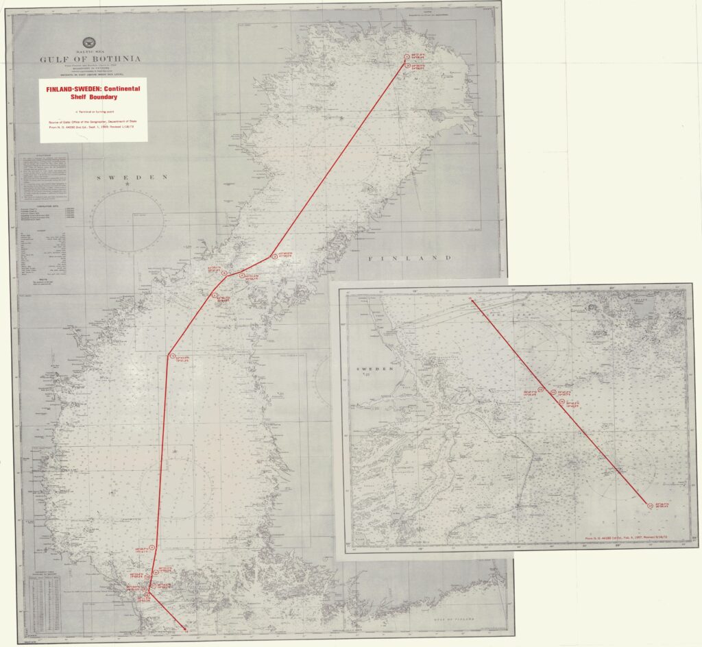
charts showing the straight baselines and the outer limits of the territorial sea of Finland, and the median line separating the continental shelf and fishery zones of Finland from the continental shelves and exclusive economic zones of Estonia and Sweden

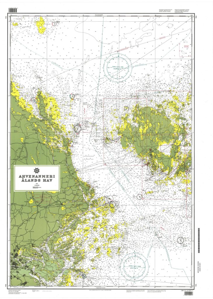
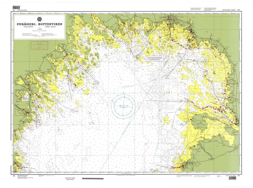
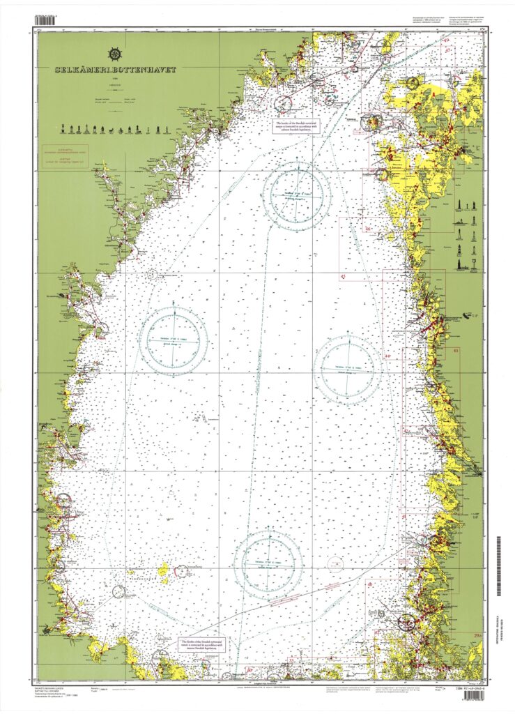
The Finland-Sweden continental shelf agreement is plotted on the attached DMA/HC charts 44030 and 44180. The official Finnish nautical charts cited in Article 6 of the Agreement were used to compute the distances between the boundary points and Finnish straight baselines. Official Swedish charts Nos. 41, 42, 51, 53, and 71 (1:200,000) were used to measure distances to the Swedish baselines.
The shelf boundary extends for a distance of approximately 419.76 nautical miles and has 17 turning or terminal points. The boundary runs the entire length of the Gulf of Bothnia, through the narrow Aland Sea, and into the northernmost part of Baltic Sea.
As stated in Article 2 of the Agreement, the first point on the boundary is the intersection of Sweden’s territorial sea limit (4 nautical miles) with the Finland-Sweden territorial sea lateral boundary. From point 1 to point 2 the shelf boundary coincides with the territorial sea boundary. At point 2 the outer limit of Finland’s territorial sea (4 nautical miles) intersects the territorial sea and the shelf boundaries. Both states employ a straight baseline system when delimiting their territorial seas.1
The straight line connecting points 2 and 3 is 130.48 nautical miles in length and constitutes the longest single segment of the boundary. Point 9 represents the intersection of the outer limit of Sweden’s territorial sea with the straight line between point 8 and the middle of Market. Sweden’s 4-nautical-mile territorial sea is, at this point, measured from Market. The short boundary segment from point 9 to point 10 (0.20 nautical miles) coincides with Sweden’s territorial sea.
Point 10, according to the Agreement, represents the intersection of Finland’s territorial sea limit with the straight line between point 8 and Market. An interesting question arises with regard to Finland’s territorial sea limit in the Aland Sea. According to Article II of the Convention on the Non-fortification and Neutralisation of the Aland Islands (signed at Geneva, October 20, 1921), “the territorial sea of the Aland Islands are considered to extend for a distance of three nautical miles from the low-water mark in the islands, islets, and reefs not permanently submerged.” In Article 1 of Decree No. 643 of August 18, 1956, establishing Finland’s straight baselines system, reference is made to the 1921 Convention regarding the territorial sea limit in the Aland Sea. Yet, on the official Finnish charts Finland’s territorial sea in this area is shown to be 4 nautical miles and not 3 nautical miles.
Article 5 of the Finland-Sweden Agreement states only that “points 8, 13, 15, and 17 referred in Articles 3-4 are identical with the points designated in the Aland Convention of 1921 as points 17, 15, 14, and 13, respectively” (emphasis added). Referring to International Legislation No. 54, p. 747, a slight discrepancy occurs between the above four points of the 1921 Aland Convention with the above four points of the Finland- Sweden Agreement. This discrepancy is probably a result of more accurate, modern surveys. The following is a comparison of the 1921 Convention points with the Finland-Sweden
Although Article 1 of the shelf agreement states that the boundary “shall in principle be a median line between the baselines,” at no point is the boundary truly equidistant. For a boundary to meet this criterion the entire boundary must be equidistant from two points (one point on each coast or baseline) with the turning points equidistant from three points (two points on one baseline, one point on the other). On this shelf boundary the turning points are not even equidistant from two points.
This fact is recognized by both states. Special circumstances are cited in Article 1; these special circumstances consist of using boundary lines fixed partly in 1811 and partly in the 1921 Convention mentioned earlier. The Agreement also states that, “in order that the boundary line may have a practical and suitable extension it shall be made up of straight lines between points in Arts. 2-4.”
The following table shows the distance from the respective baselines to the boundary and the distance between the boundary turning points.