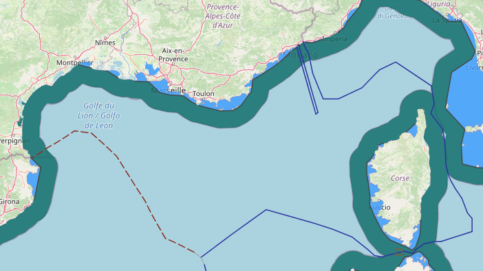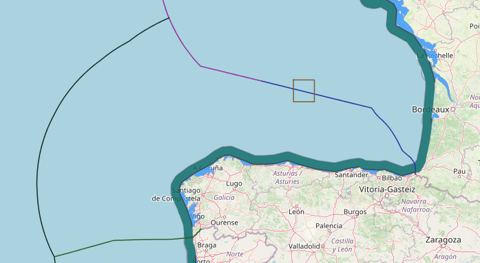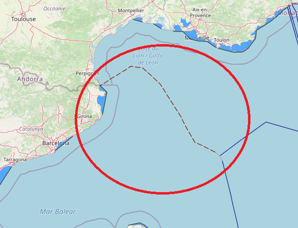
Till now, France and Spain maritime border in west of Mediterranean sea, at the lion gulf isn’t settled. in here we can see just Communication from the Government of Spain dated 23 October 2012 (transmitted by a note verbale dated 27 March 2013).
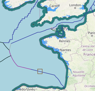
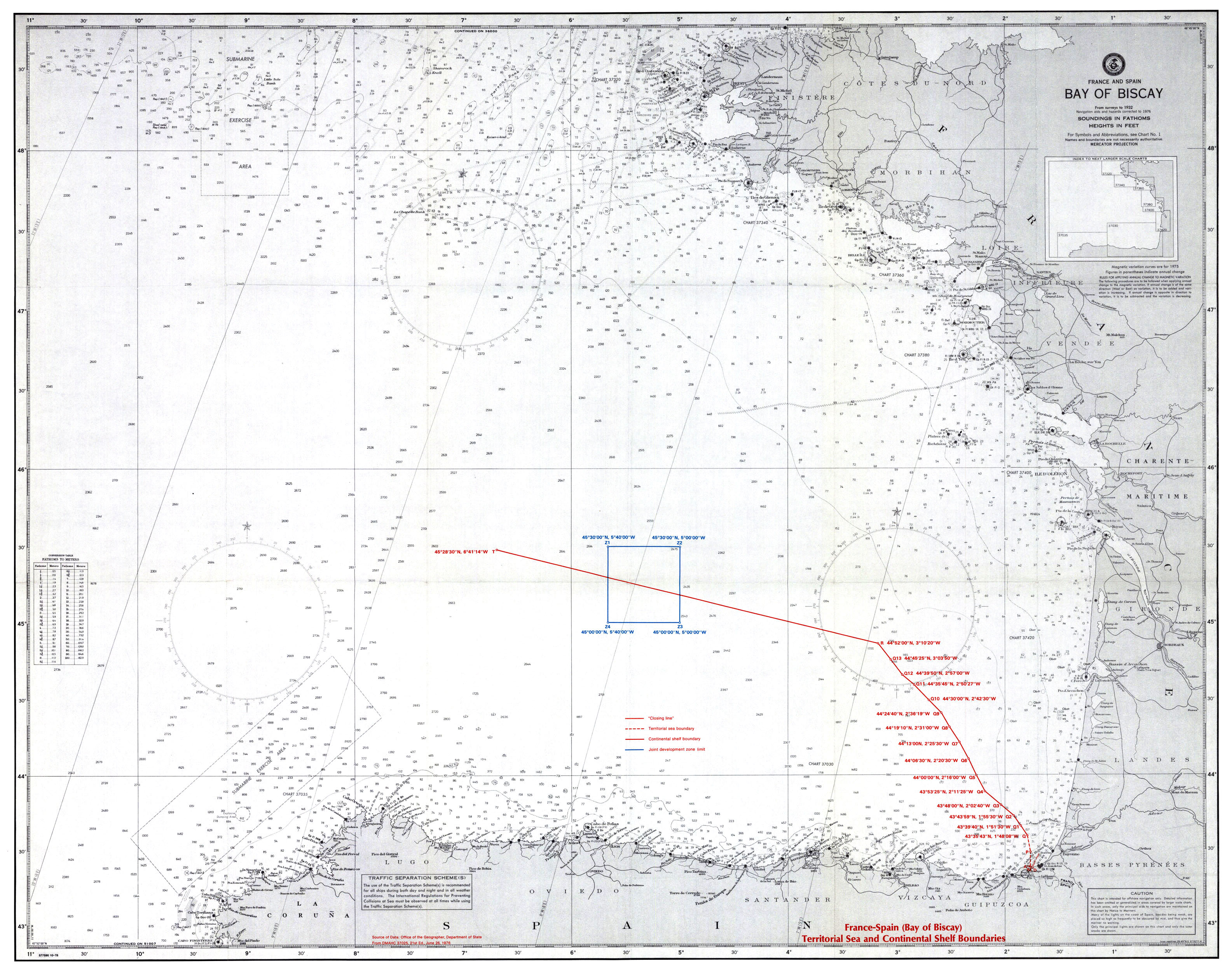
The Territorial Sea Boundary in bay of Biscay
The Franco-Spanish territorial sea and contiguous zone convention delimits the boundary
between the French 12-mile territorial sea and the Spanish 6-mile territorial sea and 12
mile contiguous zone. The territorial sea and contiguous zone boundary in the Bay of
Biscay extends for a distance of 12.4 miles from the land frontier terminus, at the mouth of
the Bidassoa estuary.
This point of origin (M) for the maritime boundary is the midpoint of a negotiated closing
line across the Bidassoa estuary mouth. The boundary extends due north for 6 miles from
the midpoint M to point P. Point P is six miles from M but approximately 5.4 miles from the
respective national baselines. An island exists on the Spanish side and a drying reef on
the French side, both of which lie seaward of point M.
The boundary then extends north-northwestward to point Q (4335’43″N; 148’08″W),
which is 12 miles from the nearest points on the respective baselines. The convention, in
Article 3, provides for these two segments to become the territorial sea limit of both states
“in the event Spain extends its [territorial sea] limits….” Law 15/1978 of February 20, 1978,
in force February 23, 1978, creates a system of
Spanish straight baselines, a 12-mile territorial sea, and a 200-mile economic zone. As a
consequence, the line M – P – Q now comprises, in its entirety, the limits between the
national territorial sea claims.
The Continental Shelf Boundary bay of Biscay
The convention on the continental shelf establishes a continental shelf boundary which
extends from the territorial sea and contiguous zone boundary terminus, point Q, to point T
situated on the negotiated construction line connecting Pointe du Raz (France) and Cabo
Ortegal (Spain). The lengths of the specific boundary segments are as follows:
The Bay of Biscay comprises a broad “U-shaped” intrusion of the Atlantic Ocean into the
European Continent. The Spanish shore line (baseline) extends approximately east-west
from the terminus of the land boundary to form the southern limit of the Bay. For the
purposes of the continental shelf delimitation, Cabo Ortegal was selected to be the western
terminus of the Spanish baseline on the Bay of Biscay.
The French coastline (baseline), in contrast, projects generally northward from the land
boundary to the latitude of Pointe de la Negade. Here the coast’s general direction turns
sharply to the northwest. For the purposes of the delimitation, the terminus of the French
coastline to the east and northeast of the Bay of Biscay was agreed to be Pointe du Raz.
The straight construction line connecting Cabo Ortegal and Pointe du Raz defines the
agreed outer, or western, limit of the continental shelf of the Bay of Biscay. The distance
between the two terminal points (on the Clarke spheroid of 1866) measures 288.474
miles.
By agreement, for purposes of the delimitation, the French and Spanish delegations
developed “artificial coastal lines” to represent their countries’ respective coastal lengths.
The Spanish “artificial coast line” connects the terminus of the land frontier with Cabo
Ortegal. The French “artificial coast line” extends from the same origin point in straight
lines to Pointe de la Negade and thence to Pointe du Raz.
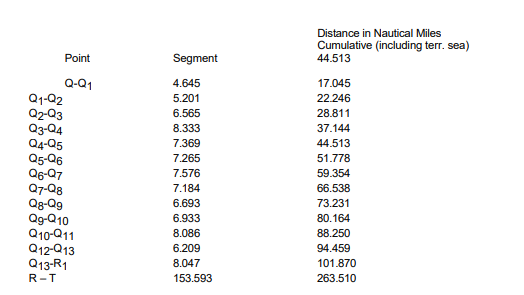
For analysis, the continental shelf delimitation may be divided into two sections. The first
extends between points Q and Q13, the second is between Q13 and T.
The Franco-Spanish continental shelf boundary from point Q to point Q13 has been
developed on the basis of equidistance. The various intermediate turning points are
situated equidistant from the nearest points on the normal baselines of the two states. The
development of this equidistant line utilized the French normal baseline northward to Cap
Ferret and the Spanish normal baseline westward to Cabo del Ajo. The length of national
baselines utilized are virtually identical, i.e., a point of equilibrium has been attained. Point
Q13 is situated approximately 68.4 miles from the respective baselines. The depth of
water at the point is approximately 1,776 fathoms (3,229 meters).
The second section of the Franco-Spanish continental shelf boundary was negotiated
according to equitable principles relating to the ratio of the artificial coastlines of the two
states.
The two states agreed to continue the equidistant boundary, with particular modifications,
to designate point R. To determine point R, point X was determined by marking the
equivalent distance of the French “artificial coastline” from point M to Pointe de la Negade
on the
Spanish “artificial coast line”, i.e., M to Pointe de la Negade = M to X. Point R, it was
agreed, would be equidistant from Pointe de Negade and from X. The location of R
appears to be a compromise; it is situated approximately halfway between the two
proposed intersections.
The Spanish proposed the continued use of equidistance as the delimitation methodology
to the point in the Bay of Biscay where the equidistant boundary would intersect the arc of
the circle with the radius of M – X. The French negotiators preferred that equidistance
cease where the equidistant line intersected the straight line joining Pointe de la Negade
with point X.
After establishing point R, the shelf area remaining to be defined within the lines Cabo
Ortegal – Pointe du Raz – Pointe de la Negade – R – X – Cabo Ortegal. The area measures
approximately 35,670 square miles. Point T was then selected on the construction line
between Cabo Ortegal and Pointe du Raz so as to apportion the continental shelf
according to the ratio of “unused” “artificial coast lines”, i.e., the distance between point X
and Cabo Ortegal versus the distance between Pointe de la Negade and Pointe du Raz.
The former has been computed to be 138.332 miles; the latter to be 213.217 miles. The
ratio of these lengths is approximately 1:1.541.
area of approximately 14,000 square miles and France, approximately 21,000 square
miles. Measurement of the areas on the chart by a digitizer computes areas of 13,561
square miles under Spanish jurisdiction and 22,109 square miles under French jurisdiction.
As noted above, the calculations using differing charts, datums, and spheroids may result
in slight discrepancies.
It is obvious, however, that the outer area of the Bay of Biscay continental shelf, as divided
by the line R – T, allocates the residual shelf according to the proportion of the national
“artificial coast lines” which was not utilized in the development of the line M – R. It should
be recalled, however, that the location of R also represents a negotiated compromise.
While the point is approximately equidistant (92.295 miles) from X and from Pointe de la
Negade, R is closer to other points on the normal baselines of the two states.
The “inner” areas allocated to the two states by the boundary between M and R measure
approximately 5,303 square miles for Spain and 4,354 square miles for France. Thus the
total maritime allocations (seaward of the artificial shore lines) would be 26,463 square
miles for France and 18,864 square miles for Spain. This ratio is approximately 1.4:1.
The final point T is situated 114.878 miles from Cabo Ortegal and 173.596 miles from
Pointe du Raz.
The convention creates in Article 3 a joint or common development zone which straddles
the shelf boundary in the segment R-T. The coordinates of this rectangle are given in
Article 3, while the development plan is detailed in Annex II. The area of the joint zone
measures 814 square miles.
The Exchange of Notes attached to the Convention states that, in the future, more precise
locations may be determined for the baselines of the two states. Nevertheless, the present
agreement will be retained. However, in Article 8, the parties have agreed if
a multilateral treaty … which would be capable of affecting the provisions of this Convention
enters into force between the Contracting Powers, they will consult with each other
immediately with a view to agreeing on such amendments to the provisions of this
Convention as appear necessary.
It is assumed that these provisions would not affect the existing boundary alignment (other
than, perhaps, to require an extension to the limit of 200-mile zones). Both France and
Spain, of course, have enabling legislation for 200-mile zones at present.