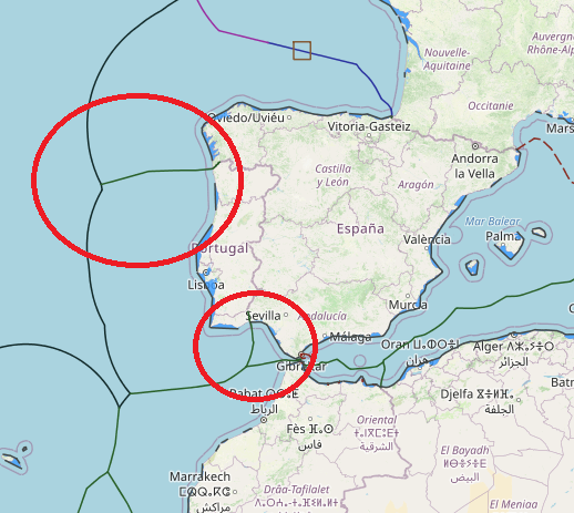
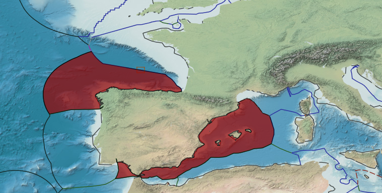
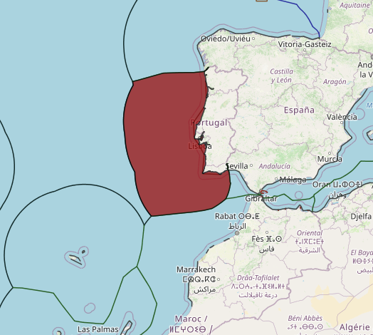
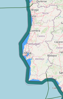
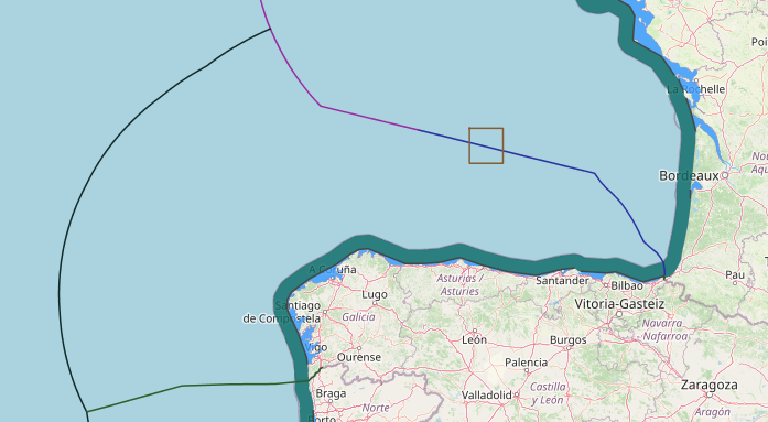
In 1976, Spain and Portugal concluded two treaties delimiting the territorial sea, contiguous zone, and continental shelf between the two States in the Atlantic Ocean. However, these treaties have not entered into force. The two countries have additional unresolved maritime boundaries, including with respect to the Canary Islands (Spain) and the Madeira Islands (Portugal). Spain’s Royal Decree of 1977 establishes a straight baseline system for its mainland coast that consists of 84 points and 75 segments. it seems that “Portugal is now opposed to ratification and favors the equidistant line for both boundaries”
- Points 1–33 lie along the north and north-west coasts of Spain (Atlantic Ocean), extending from the land boundary with France (point 1) to just north of the land boundary with Portugal (point 33).
- Points 34–42 are along southwest coast of Spain (Atlantic Ocean), from the land boundary with Portugal to the Strait of Gibraltar.
- Points 43–84 are along the south and east coasts (Mediterranean Sea), from the Strait of Gibraltar to the land boundary with France. Spain uses the normal baseline in nine relatively small areas along its mainland coast.
Spain’s coastline is generally smooth, marked by shallow indentations and promontories, with few fringing islands. In some areas the coastline is rugged and serrated, but with only small indentations (e.g., north coast, near segments 14–17). Spain’s northwest coast is characterized by numerous small bays (segments 18–27). Spain’s west coast, north of Portugal (near segments 30– 33), is characterized by deeper indentations (12–15 M) and fringing islands within the mouths of several of the indentations.
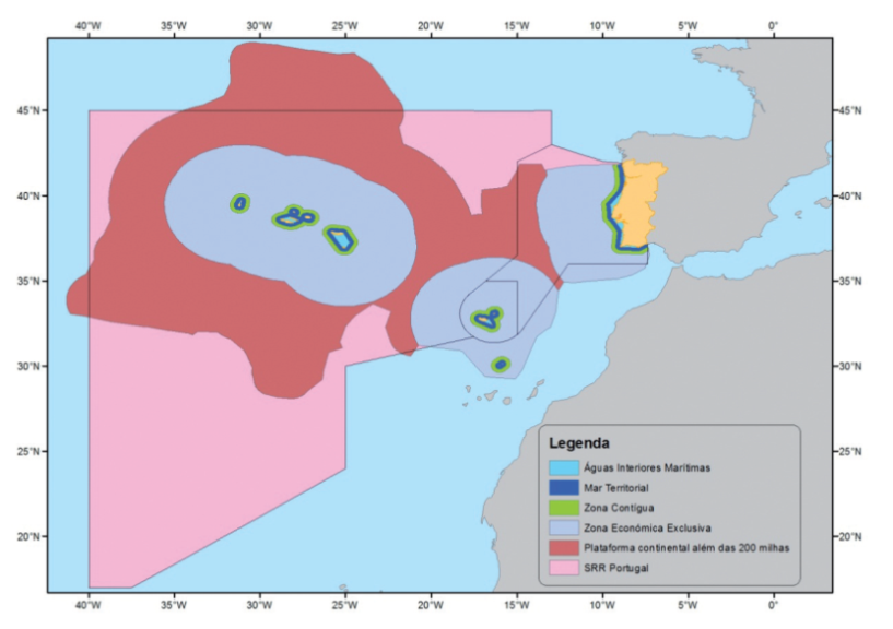
This maritime zone corresponds to the water masses that are located between the straight baseline and the coast line, outside the mouth of rivers and estuaries. According toBessathe total inland maritime waters is 6 508 Km2in the Mainland, 6 082 Km2in the archipelago of Azores and 825 Km2in the Madeira archipelago.
In the territorial sea, the coastal State exercises sovereignty over the seabed, marine subsoil and full control over the mass of water and overlying airspace. Military and State ships enjoy immunity and all other are subject to the jurisdiction of the coastal State, but enjoying the right of innocent passage, defined by being continuous, orderly and expeditious, in accordance with safety and environmental protection rules the coastal State defines. The size of Portuguese territorial sea area, considering all parts of territory, is about 50,957 Km2, 16,460 Km2of which correspond to the continent’s portion, 23,663 Km2to the Azores archipelago portion and 10,834 Km2to the archipelago portion of Madeira. The contiguous zone extends from the outer limit of territorial sea up to 24 nautical miles, measured from the baselines. According to article 33 of UNCLOS, the coastal State exercises jurisdiction in the zone that has established for national territory and territorial sea, preventing and combating crime. The Contiguous Zone is already integrated in the exclusive economic zone (EEZ, described below) and, as such, is no longer part of the Maritime Public Domain.
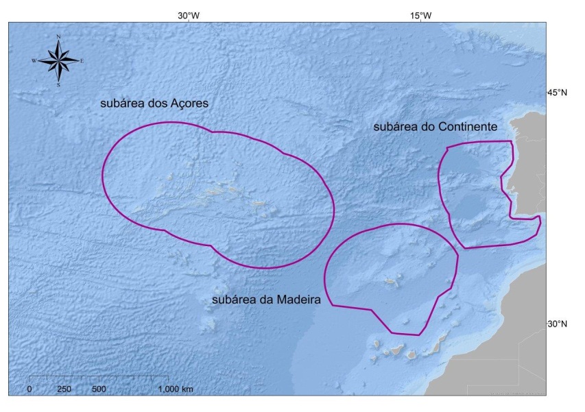
The Portuguese Exclusive Economic Zone (EEZ) includes the Portugal mainland (322,000 km2), Azores (1.06 million km2) and Madeira (454,500 km2 ), amounting to almost 50% of all European Union (EU) EEZs. However, the Portuguese mainland EEZ is the smallest component of the total Portuguese EEZ.
This sea zone, adjacent to territorial sea, shall not exceed 200 nautical miles from the baseline. The EEZ includes the contiguous zone. In the EEZ, coastal States exercise their sovereignty and jurisdiction pursuant to UNCLOS, holding the right to exploit, manage and conserve the existing living and non-living natural resources, from the waters overlying the seabed, from the seabed ??and its subsoil, including the exploration and exploitation of renewable energy resources, like wind, waves and sea currents.
Thus, coastal States can authorize, construct and regulate the construction of infrastructures for the exploitation of natural resources, including the possibility of installing artificial islands, on the EEZ. They can define safety zones, generally up to a maximum of 500 m from the limits of such infrastructures, which must be seen by ships in transit. The Portuguese EEZ comprises 3 subareas: subarea of ??the continent (287 521 km2), subarea of ??Azores (930 687 Km2) and subarea of ??Madeira (442 248 Km2).
The term “Continental Shelf” includes two distinct concepts: the geological concept and the legal concept. Although both concepts are related to a large extent, the fact is in practice they indicate very different realities, particularly in the Portuguese case.
The continental geological platform concerns the portion of the bed and subsoil of submarine areas which, starting at the coastline, extend with a gentle slope up to a mean depth somewhere between 200 and 300 meters in the transition of the continental slope. The continental shelf legal concept has been expressed in UNCLOS, in particular on n.º 1 of Article 76 of the Convention, which states that the continental shelf of a coastal state “comprises the bed and subsoil of submarine areas which extend beyond its territorial sea over the whole natural extension of their terrestrial territory to the outer edge of the continental margin or up to 200 nautical miles from the baselines from which the territorial sea width is measured, in cases where the outer edge of the continental margin does not reach that distance“.
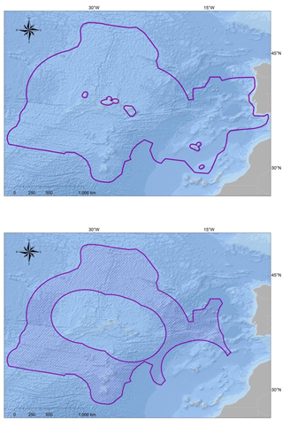
However, and according to n.º 4 of Article 76 of the Convention, the coastal State may establish the outer limit of its continental shelf beyond 200 nautical miles in accordance with scientific criteria. In 2009, Portugal submitted to the Commission on the Limits of the Continental Shelf (CLCS) the demarcation of its continental shelf outer limits beyond 200 nautical miles. The outer continental shelf was submitted considering 3 regions: eastern region – comprising the extension of the platform relating to Madeira archipelago and the mainland; the western region – comprising the extension relating to Azores archipelago; and the Bank of Galicia region, which is an area of common interest to Portugal and Spain, still not divided by bilateral agreement. The coastal State exercises sovereign rights over the continental shelf for the purpose of exploring and exploiting its natural resources, which are exclusive in the sense that, if the coastal State does not exploit the continental shelf or doesn’t take advantage of its natural resources, no one can undertake these activities without its express consent.

