
The definition of the continental shelf and criteria for the establishment of its outer limits
The definition of the continental shelf and the criteria by which a coastal State may establish the outer limits of its continental shelf are set out in article 76 of the Convention. In addition, the Third United Nations Conference on the Law of the Sea (the “Conference”) adopted on 29 August 1980 a “Statement of Understanding” which is contained in Annex II to the Final Act of the Conference.
The term “continental shelf” is used by geologists generally to mean that part of the continental margin which is between the shoreline and the shelf break or, where there is no noticeable slope, between the shoreline and the point where the depth of the superjacent water is approximately between 100 and 200 metres. However, this term is used in article 76 as a juridical term. According to the Convention, the continental shelf of a coastal State comprises the submerged prolongation of the land territory of the coastal State – the seabed and subsoil of the submarine areas that extend beyond its territorial sea to the outer edge of the continental margin, or to a distance of 200 nautical miles where the outer edge of the continental margin does not extend up to that distance. The continental margin consists of the seabed and subsoil of the shelf, the slope and the rise. It does not include the deep ocean floor with its oceanic ridges or the subsoil thereof .
According to article 76, the coastal State may establish the outer limits of its juridical continental shelf wherever the continental margin extends beyond 200 nautical miles by establishing the foot of the continental slope, by meeting the requirements of article 76, paragraphs 4 – 7, of the Convention.
based on the the treaty of continental shelf 1958, Article 1 of the convention defined the term shelf in terms of exploitability rather than relying upon the geological definition. It defined a shelf “to the seabed and subsoil of the submarine areas adjacent to the coast but outside the area of the territorial sea, to a depth of 200 meters or, beyond that limit, to where the depth of the superjacent waters admits of the exploitation of the natural resources of the said areas” or “to the seabed and subsoil of similar submarine areas adjacent to the coasts of islands”.
Besides outlining what is legal in continental shelf areas, it also dictated what could not be done in Article 5.
also based on the article 76 of UNCLOS III,
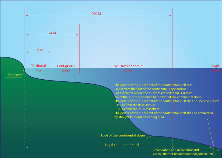
Article76, Definition of the continental shelf
- The continental shelf of a coastal State comprises the seabed and subsoil of the submarine areas that extend beyond its territorial sea throughout the natural prolongation of its land territory to the outer edge of the continental margin, or to a distance of 200 nautical miles from the baselines from which the breadth of the territorial sea is measured where the outer edge of the continental margin does not extend up to that distance.
- The continental shelf of a coastal State shall not extend beyond the limits provided for in paragraphs 4 to 6.
- The continental margin comprises the submerged prolongation of the land mass of the coastal State, and consists of the seabed and subsoil of the shelf, the slope and the rise. It does not include the deep ocean floor with its oceanic ridges or the subsoil thereof.
- (a) For the purposes of this Convention, the coastal State shall establish the outer edge of the continental margin wherever the margin extends beyond 200 nautical miles from the baselines from which the breadth of the territorial sea is measured, by either:
(i) a line delineated in accordance with paragraph 7 by reference to the outermost fixed points at each of which the thickness of sedimentary rocks is at least 1 per cent of the shortest distance from such point to the foot of the continental slope; or
(ii) a line delineated in accordance with paragraph 7 by reference to fixed points not more than 60 nautical miles from the foot of the continental slope.
(b) In the absence of evidence to the contrary, the foot of the continental slope shall be determined as the point of maximum change in the gradient at its base.
- The fixed points comprising the line of the outer limits of the continental shelf on the seabed, drawn in accordance with paragraph 4 (a)(i) and (ii), either shall not exceed 350 nautical miles from the baselines from which the breadth of the territorial sea is measured or shall not exceed 100 nautical miles from the 2,500 metre isobath, which is a line connecting the depth of 2,500 metres.
- Notwithstanding the provisions of paragraph 5, on submarine ridges, the outer limit of the continental shelf shall not exceed 350 nautical miles from the baselines from which the breadth of the territorial sea is measured. This paragraph does not apply to submarine elevations that are natural components of the continental margin, such as its plateaux, rises, caps, banks and spurs.
- The coastal State shall delineate the outer limits of its continental shelf, where that shelf extends beyond 200 nautical miles from the baselines from which the breadth of the territorial sea is measured, by straight lines not exceeding 60 nautical miles in length, connecting fixed points, defined by coordinates of latitude and longitude.
- Information on the limits of the continental shelf beyond 200 nautical miles from the baselines from which the breadth of the territorial sea is measured shall be submitted by the coastal State to the Commission on the Limits of the Continental Shelf set up under Annex II on the basis of equitable geographical representation. The Commission shall make recommendations to coastal States on matters related to the establishment of the outer limits of their continental shelf. The limits of the shelf established by a coastal State on the basis of these recommendations shall be final and binding.
- The coastal State shall deposit with the Secretary-General of the United Nations charts and relevant information, including geodetic data, permanently describing the outer limits of its continental shelf. The Secretary-General shall give due publicity thereto.
- The provisions of this article are without prejudice to the question of delimitation of the continental shelf between States with opposite or adjacent coasts.
Article77
Rights of the coastal State over the continental shelf
- The coastal State exercises over the continental shelf sovereign rights for the purpose of exploring it and exploiting its natural resources.
- The rights referred to in paragraph 1 are exclusive in the sense that if the coastal State does not explore the continental shelf or exploit its natural resources, no one may undertake these activities without the express consent of the coastal State.
- The rights of the coastal State over the continental shelf do not depend on occupation, effective or notional, or on any express proclamation.
- The natural resources referred to in this Part consist of the mineral and other non-living resources of the seabed and subsoil together with living organisms belonging to sedentary species, that is to say, organisms which, at the harvestable stage, either are immobile on or under the seabed or are unable to move except in constant physical contact with the seabed or the subsoil.
What is an example of a continental shelf?
Example of a Continental Shelf Landform: Siberian Shelf, Arctic Ocean. The picture is of Southeast Florida Continental Shelf (It is under water). It is smaller than the side in the Gulf of Mexico.
What are 3 characteristics of the continental shelf?
Continental shelves are usually covered with a layer of sand, silts, and silty muds. Their surfaces exhibit some relief, featuring small hills and ridges that alternate with shallow depressions and valleylike troughs.
What are the three types of continental shelves?
The shelf area is commonly subdivided into the inner continental shelf, mid continental shelf, and outer continental shelf, each with their specific geomorphology and marine biology.
Are mid-ocean ridges?
The mid-ocean ridge is a continuous range of undersea volcanic mountains that encircles the globe almost entirely underwater. … It formed and evolves as a result of spreading in Earth’s lithosphere—the crust and upper mantle—at the divergent boundaries between tectonic plates.
Why do continental shelves have high fish productivity?
One of the reasons for this higher productivity is the increased nutrient loads via runoff from the continental landmasses (mostly by rivers), however many shelf areas receive significant nutrients from upwelling of deeper ocean waters.
Where are seamounts located?
Seamounts are commonly found near the boundaries of Earth’s tectonic plates and mid-plate near hotspots. At mid-ocean ridges, plates are spreading apart and magma rises to fill the gaps.
What is continental shelf Upsc?
The continental shelf is the stretched margin of all continent occupied by comparatively shallow gulfs and sea. It is the shallowest part of the ocean. The shelf normally ends at a very steep slope which is called the shelf break. The average width of continental shelves is about 80 km.
What animals live on the continental slope?
Dover sole, sablefish, and rockfish (fig. 4) have this type of life history; however, most species living deeper, such as rattails, deep-sea soles, and slickheads, have young that live in the same depths as adults. Relatively few species occur at all or most depths on the Continental Slope.
How deep does the ocean go down?
The average depth of the ocean is about 12,100 feet . The deepest part of the ocean is called the Challenger Deep and is located beneath the western Pacific Ocean in the southern end of the Mariana Trench, which runs several hundred kilometers southwest of the U.S. territorial island of Guam.
Where is the narrowest continental shelf?
The widest shelves are in the Arctic Ocean off the northern coasts of Siberia and North America . Some of the narrowest shelves are found off the tectonically active western coasts of North and South America .
Are tectonic plates?
A tectonic plate (also called lithospheric plate) is a massive, irregularly shaped slab of solid rock, generally composed of both continental and oceanic lithosphere. Plate size can vary greatly, from a few hundred to thousands of kilometers across; the Pacific and Antarctic Plates are among the largest.
Where can you find the oldest seafloor?
the Mediterranean SeaThe oldest seafloor is comparatively very young, approximately 280 million years old. It is found in the Mediterranean Sea and is a remnant of an ancient ocean that is disappearing between Africa and Europe.
Where is continental rise found?
The continental rise is a low-relief zone of accumulated sediments that lies between the continental slope and the abyssal plain. It is a major part of the continental margin, covering around 10% of the ocean floor.
How deep is the abyssal plain?
10,000 feetAt depths of over 10,000 feet and covering 70% of the ocean floor, abyssal plains are the largest habitat on earth. Sunlight does not penetrate to the sea floor, making these deep, dark ecosystems less productive than those along the continental shelf.