Impacts of Global Warming on Marine Boundaries: An Analytical Overview
View More Impacts of Global Warming on Marine Boundaries: An Analytical OverviewCategory: Maritime Claims
Legal Challenges in Madagascar’s Maritime Domain: An Analytical Perspective
Title: Legal Challenges in Madagascar’s Maritime Domain: An Analytical Perspective Excerpt: Madagascar’s maritime domain presents a complex web of legal challenges, demanding nuanced analysis for effective resolution. As a country rich in marine resources and vulnerable to various maritime threats, Madagascar faces critical issues pertaining to territorial claims, illegal fishing, maritime security, and environmental protection. This article aims to provide a professional and analytical perspective on the legal complexities surrounding Madagascar’s maritime domain, highlighting the need for comprehensive strategies to safeguard its marine ecosystems and promote sustainable development.
View More Legal Challenges in Madagascar’s Maritime Domain: An Analytical PerspectiveMadagascar’s Legal Conundrums: Navigating the Seas of Justice
Exploring Madagascar’s Law Labyrinth: Sailing through Turbulent Waters of Justice
View More Madagascar’s Legal Conundrums: Navigating the Seas of JusticeTackling Tasmania’s Maritime Challenges: Exploring Key Issues
Tackling Tasmania’s Maritime Challenges: Exploring Key Issues Tasmania’s maritime sector faces a range of challenges that demand attention and strategic solutions. From climate change impacts to maritime safety concerns, understanding these key issues is crucial for effective planning and decision-making. This article delves into the complexities of Tasmania’s maritime challenges, providing insight into their impacts and exploring potential avenues for resolving them. With a focus on professionalism and informative analysis, we aim to shed light on this critical aspect of Tasmania’s economy and environment.
View More Tackling Tasmania’s Maritime Challenges: Exploring Key IssuesBrewing Tensions: India-Pakistan Rivalry Extends to the Seas
Introduction The long-standing rivalry between India and Pakistan extends beyond their disputed borders, often manifesting in various forms, including military conflicts, political disputes, and territorial…
View More Brewing Tensions: India-Pakistan Rivalry Extends to the SeasChanneling Success: Overcoming Maritime Challenges in France and Britain
Navigating the Storm: Conquering Maritime Hurdles in France and Britain
View More Channeling Success: Overcoming Maritime Challenges in France and Britain
Enchanting British Waters: A Captivating Exploration
Enchanting British Waters: A Captivating Exploration Dive deep into the mystical wonders of British waters, where breathtaking beauty meets untamed wilderness. Embark on a journey that unveils the secrets hidden beneath the waves, a captivating exploration of marine marvels. Immerse yourself in the ethereal world where mermaids dance amidst vibrant coral reefs and sea creatures whisper legends of the ancient seas. Let the enchantment of British waters bewitch your senses and ignite a profound appreciation for the mesmerizing diversity that lies beneath. Join us as we embark on this extraordinary adventure, where the allure of the unknown beckons you to delve into the depths of the sea.
View More Enchanting British Waters: A Captivating ExplorationUnveiling Australia’s Antarctic Adventure: Overcoming the Frozen Frontiers
Antarctica: A land shrouded in mystery, beckoning adventurers to conquer its frozen frontiers. Join us as we unveil Australia’s extraordinary Antarctic expedition, a daring quest to unravel the secrets of the icy continent. Brace yourselves for a mesmerizing tale of courage, curiosity, and triumph in one of the harshest environments on Earth.
View More Unveiling Australia’s Antarctic Adventure: Overcoming the Frozen FrontiersThe Timor Sea: Australia’s Maritime Trials
Navigating the Timor Sea: Australia’s Maritime Maze
View More The Timor Sea: Australia’s Maritime TrialsEast Meets West: Navigating Challenges in the South China Sea
East Meets West: Exploring South China Sea’s Perilous Waters
View More East Meets West: Navigating Challenges in the South China SeaChallenges of China and the Philippines in the South China Sea
Title: Challenges in the South China Sea: China and the Philippines Excerpt: Amidst the complex geopolitical landscape, both China and the Philippines face multifaceted challenges in the contested waters of the South China Sea. This article delves into the intricacies of their respective struggles and examines the potential ramifications for regional stability and international relations.
View More Challenges of China and the Philippines in the South China SeaChallenges of China and Japan in the South China Sea
China and Japan face hurdles in the South China Sea due to territorial disputes, geopolitical tensions, and competing interests.
View More Challenges of China and Japan in the South China SeaChina-US Maritime Challenges: Examining Complexities in the South China Sea
Title: China-US Maritime Challenges: Complexities in the South China Sea Excerpt: Amidst escalating tensions, the South China Sea has emerged as a hotbed of maritime complexities between China and the United States. With both nations vying for dominance in the region, this article delves into the intricate dynamics that define this geopolitical battleground.
View More China-US Maritime Challenges: Examining Complexities in the South China SeaChina and America’s Maritime Missteps: Overcoming Challenges in the South China Sea
Navigating Troubled Waters: Resolving Sino-American Tensions in the South China Sea
View More China and America’s Maritime Missteps: Overcoming Challenges in the South China SeaThe Persian Gulf’s Oil Odyssey: Iran and Kuwait’s Resource Conundrum
Title: The Persian Gulf’s Oil Odyssey: Iran and Kuwait’s Resource Conundrum Excerpt: In the realm of black gold, where geopolitics and resource abundance converge, Iran and Kuwait find themselves entangled in an oil Odyssey. As the Persian Gulf’s sovereign partners, their journey is shaped by complex dynamics, regional rivalries, and the quest for energy supremacy. Amidst these turbid waters, both nations are faced with a conundrum: how to navigate the treacherous tides of resource management while maintaining stability in an ever-evolving global energy landscape.
View More The Persian Gulf’s Oil Odyssey: Iran and Kuwait’s Resource ConundrumIran-Kuwait Oil Dispute: A Clash Over Resources
Title: Iran-Kuwait Oil Dispute: A Clash Over Resources Excerpt: Amidst the shifting tides of global energy dynamics, the Iran-Kuwait oil dispute emerges as a formidable clash over valuable resources. The professional tone of this article delves deep into the descriptive intricacies of this ongoing conflict, analyzing the complex motivations and geopolitical implications at play.
View More Iran-Kuwait Oil Dispute: A Clash Over ResourcesAnalyzing Iran’s Arash Oil Field: Insights and Perspectives
Analyzing Iran’s Arash Oil Field: Insights and Perspectives
View More Analyzing Iran’s Arash Oil Field: Insights and PerspectivesUnveiling the Kuwaiti Oil Field: Decoding its Secrets
Unveiling Kuwaiti Oil Field: Decoding its Secrets
View More Unveiling the Kuwaiti Oil Field: Decoding its Secrets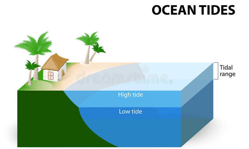
About tide in the Ocean(The Tidal Ocean)
Twice a day, the sea rises up the shore then falls back again
in tides. However, the effect is only local. While the tide
is rising in one place, it is falling in another, as huge forces are
exerted on the vast mass of water in the oceans.
Tides fall in one place and rise in another because the water in
the oceans is moving around, flowing this way and that across the
face of the planet, so that it piles up in one place, making the tide
flow in, and drops away in another, making the tide ebb. It is this
continual ebb and flow of ocean water that makes many simple
explanations of why tides occur misleading or wrong.
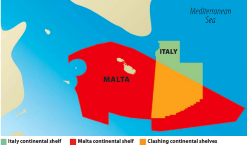
hypothetical line of delimitation between Italy and Malta
INFORMAL AGREEMENT BETWEEN ITALY, MALTA ON MORATORIUM OFFSHORE SICILY A new chapter has opened in the relations between Italy and Malta: Rome and Valletta agreed “informally” to suspend oil drilling in the Southeastern area of Sicily where the respective claims are overlapped.
The political commitment given by the two Countries allows to glimpse prospects for resolving their long standing dispute on the delimitation of the continental shelf (CS) as well as expresses the always excellent level of their bilateral relations. The agreement must be however followed by the formal delimitation of the maritime boundary. Moreover there is a third party concerned to be considered: Libya, whose continental shelf borders the hypothetical limits of both Italy and Malta’s CS.
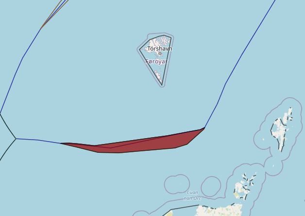
Denmark(Faroe Islands)–United Kingdom maritime boundary and Special Area
In May 1999 Denmark and the United Kingdom concluded an agreement (1999 Agreement) concerning their overlapping claims to fisheries zones and continental shelf in North Atlantic waters located between the Faroe Islands and Scotland. The 1999 Agreement designates continental shelf and fisheries zone boundaries in addition to a ‘Special Area’ of water column that remains subject to the overlapping jurisdictional claims both States.
View More Denmark(Faroe Islands)–United Kingdom maritime boundary and Special Area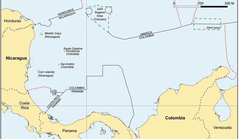
Colombia–Jamaica maritime boundary and the Joint Regime Area
In 1993 Colombia and Jamaica concluded a treaty (1993 Treaty) concerning their overlapping claims to a continental shelf and EEZ in the Caribbean Sea. Article 1 of the 1993 Treaty establishes a maritime boundary between the two States. Immediately to the west of the boundary, the 1993 Treaty also establishes a ‘Joint Regime Area’ in which, ‘pending the determination of the jurisdictional limits of each Party …, the Parties agree to establish … a zone of joint management, control, exploration and exploitation of living and non-living resources’. Article 3(1), sub-paragraphs (b) and (c) of the 1993 Treaty exclude two circular areas of 12 nautical miles radius from the Joint Regime Area. One circular area surrounds the cays of the Seranilla Bank and the other surrounds the cays of Bajo Nuevo. Both of these groups of features are claimed by Colombia – a claim that has been disputed on various occasions by Honduras, Jamaica, Nicaragua and the United States.
View More Colombia–Jamaica maritime boundary and the Joint Regime Area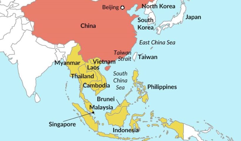
China geopolitical interests in eastern Asia and south china sea
The establishment of the People’s Republic of China (PRC) was proclaimed by Mao Zedong on October 1, 1949 at Tiananmen Square in Beijing. This followed two decades of almost constant turmoil that took the form of a prolonged civil war between the Nationalist Party, or Kuomintang (KMT), and the Chinese Communist Party (CCP) as well as the Japanese invasion of China, which resulted in the eight year Sino-Japanese War (1937–45). Following Chiang Kai-shek’s split with the CCP after his massacre of thousands of Communists in Shanghai in March 1927, the Nationalists were soon faced with a series of armed insurrections led by the Communists in cities such as Nanchang and Guangzhou. These uprisings ultimately proved unsuccessful. The Communists were driven into the countryside, where the Nationalists proceeded to wage a total of five campaigns of “extermination” between 1930 and 1934, aimed at achieving a comprehensive victory. The success of the fifth campaign in encircling and strangling the Communists led the latter to abandon their base in Jiangxi Province in October 1934 and stage the famous “Long March,” a 4,000-mile journey to establish a new base in Shaanxi in northwest China. China would soon be faced by the even greater threat of external invasion. The Japanese had established a presence in Manchuria by 1931. Growing domestic expansionist pressures led to an undeclared war with China following the “Marco Polo Bridge Incident” on July 7, 1937. Following the outbreak of hostilities, the Communists and Nationalists formed a “United Front” with the goal of defeating the Japanese, although the conflict between the CCP and the KMT was never resolved. Despite its initial success in taking many of the key coastal cities, including Shanghai, and eventually the Nationalist capital of Nanjing, the Japanese advance soon stalled. The Japanese army was never able to penetrate deep into the Chinese countryside. The Japanese surrender on August 14, 1945, following the dropping of atomic bombs on Hiroshima and Nagasaki, plunged China back into civil war. The Communists soon gained the upper hand, eventually driving the KMT out of China and into Taiwan, paving the way for the establishment of the People’s Republic of China.
View More China geopolitical interests in eastern Asia and south china sea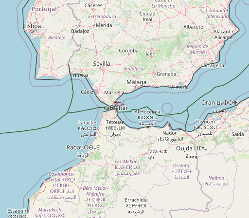
maritime boundaries between Spain and morocco
The pending maritime delimitations between Spain and Morocco are highly complex and noteworthy due to the existence of diverse factors, namely the particularity that the delimitations shall be conducted in two different seas: the Alboran Sea and the Atlantic Ocean. Moreover, various sovereignty issues must be addressed, such as the Spanish enclaves in North Africa, which are claimed by Morocco generating maritime entitlements, and the Western Sahara dispute and Morocco’s intention to include the Western Sahara maritime areas under its jurisdiction. In terms of the latter issue, this article studies the fisheries agreements concluded between the European Union and Morocco and the recent decisions given by the Court of Justice of the European Union, declaring those agreements prohibited under international law in respect of Western Sahara waters. Other significant matters analyzed are the views of both countries, the existence of several overlapping maritime claims with third States and the negotiations that have been carried out thus far to reach an agreement delimiting the maritime boundaries. On this subject, it is crucial to determine whether a tacit agreement exists – on the basis of the hydrocarbon activities licensed by Spain and Morocco – establishing the maritime boundary between the Canary Islands and Morocco’s Atlantic coast.
View More maritime boundaries between Spain and morocco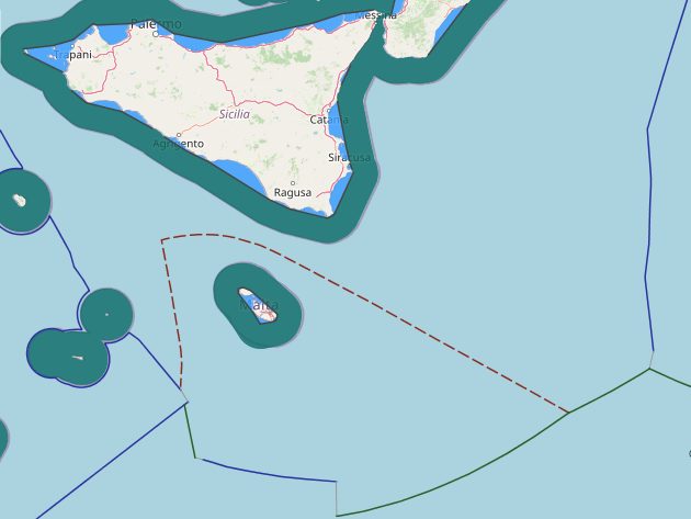
maritime boundaries between Italy and Malta
maritime boundaries between Italy and Malta,
View More maritime boundaries between Italy and Malta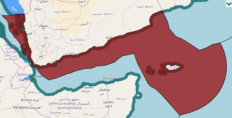
Yemen maritime claim about baselines(straight baseline) for measuring the breadth of the territorial sea
Maritime Claims, yemen, Yemen Arab Republic maritime claim, Yemen continental shelf map, Yemen EEZ map, Yemen exclusive economic zone map, Yemen internal waters map, Yemen maritime boundaries, Yemen maritime claims, Yemen territorial waters map
View More Yemen maritime claim about baselines(straight baseline) for measuring the breadth of the territorial sea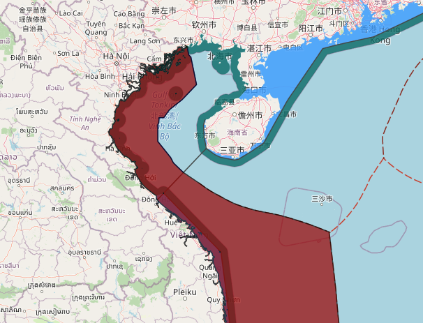
Viet Nam maritime claims about Delimitation of the Territorial Sea, the Exclusive Economic Zone and Continental Shelf, such as in the Gulf of Tonkin with China
Maritime Claims, Viet Nam continental shelf map, Viet Nam EEZ map, Viet Nam exclusive economic zone map, Viet Nam internal waters map, Viet Nam maritime boundaries, Viet Nam maritime claims, Viet Nam territorial waters map
View More Viet Nam maritime claims about Delimitation of the Territorial Sea, the Exclusive Economic Zone and Continental Shelf, such as in the Gulf of Tonkin with China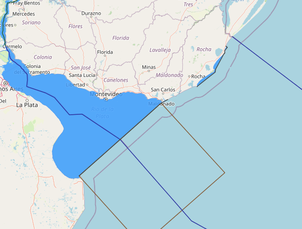
Uruguay maritime claims about straight baselines and the outer limit of the territorial sea, the contiguous zone and the exclusive economic zone
Maritime Claims, Uruguay, Uruguay continental shelf map, Uruguay EEZ map, Uruguay exclusive economic zone map, Uruguay internal waters map, Uruguay maritime boundaries, Uruguay maritime claims, Uruguay territorial waters map
View More Uruguay maritime claims about straight baselines and the outer limit of the territorial sea, the contiguous zone and the exclusive economic zone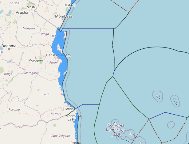
Tanzania maritime claims about straight baselines
Maritime Claims, Tanzania, Tanzania continental shelf map, Tanzania EEZ map, Tanzania exclusive economic zone map, Tanzania internal waters map, Tanzania maritime boundaries, Tanzania maritime claims, Tanzania straight baseline claim, Tanzania territorial waters map
View More Tanzania maritime claims about straight baselines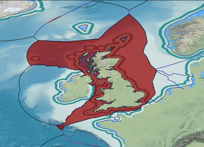
UK maritime claims about outer limit of extended continental shelf and exclusive economic zone
Great Britain, Great Britain continental shelf map, Great Britain exclusive economic zone map, Great Britain internal and territorial waters map, Great Britain maritime claims, Maritime Claims, UK, UK continental shelf map, UK EEZ map, UK exclusive economic zone map, UK internal waters map, UK maritime boundaries, UK maritime claims, UK territorial waters map
View More UK maritime claims about outer limit of extended continental shelf and exclusive economic zone
UK maritime claims about defining the outer limits of a zone adjacent to the territorial sea of the British Indian Ocean Territory, known as the Environment (Protection and Preservation) Zone
British Indian Ocean Territory, Environment (Protection and Preservation) Zone, UK maritime boundaries, UK maritime claims
View More UK maritime claims about defining the outer limits of a zone adjacent to the territorial sea of the British Indian Ocean Territory, known as the Environment (Protection and Preservation) Zone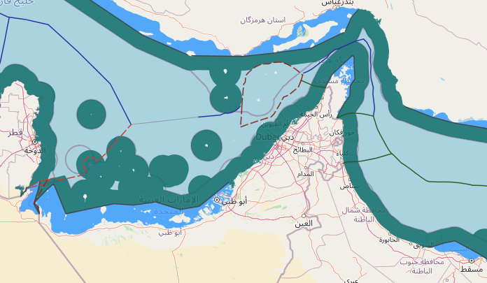
United Arab Emirates maritime claims about Straight Baselines System in Persian Gulf
Maritime Claims, UAE maritime zones, United Arab Emirates, United Arab Emirates continental shelf map, United Arab Emirates EEZ map, United Arab Emirates exclusive economic zone map, United Arab Emirates internal waters map, United Arab Emirates maritime boundaries, United Arab Emirates maritime claims, United Arab Emirates maritime zone, United Arab Emirates territorial waters map
View More United Arab Emirates maritime claims about Straight Baselines System in Persian Gulf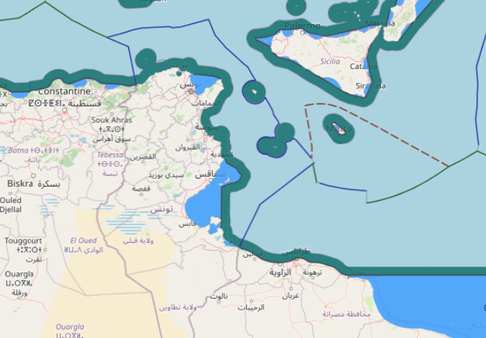
Tunisia maritime claims about drawing of straight baselines
Maritime Claims, Tunisia, Tunisia continental shelf map, Tunisia EEZ map, Tunisia exclusive economic zone map, Tunisia internal waters map, Tunisia maritime boundaries, Tunisia maritime claims, Tunisia territorial waters map
View More Tunisia maritime claims about drawing of straight baselines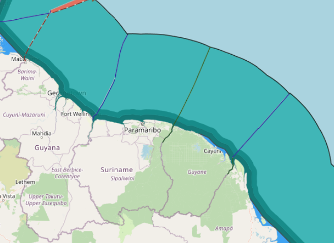
Suriname maritime claims about outer limits of the continental shelf beyond 200 nautical miles
Maritime Claims, Suriname, Suriname continental shelf beyond 200 nautical miles, Suriname continental shelf map, Suriname EEZ map, Suriname exclusive economic zone map, Suriname internal waters map, Suriname maritime boundaries, Suriname maritime claims, Suriname maritime map and chart, Suriname territorial waters map
View More Suriname maritime claims about outer limits of the continental shelf beyond 200 nautical miles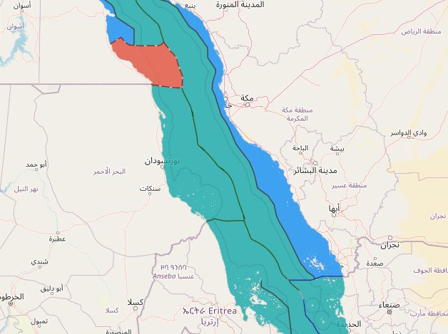
Sudan maritime claims about straight baseline in the Red Sea
Maritime Claims, straight baseline in the Red Sea, Sudan, Sudan continental shelf map, Sudan EEZ map, Sudan internal waters map, Sudan maritime boundaries, Sudan maritime claims
View More Sudan maritime claims about straight baseline in the Red Sea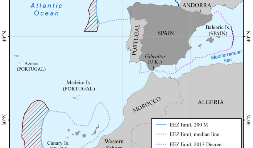
Spain maritime claims, such as limits of the Fisheries Protection Zone in the Mediterranean Sea
Fisheries Protection Zone in the Mediterranean Sea, spain, Spain continental shelf map, Spain EEZ map, Spain exclusive economic zone map, Spain Fisheries Protection Zone claim, Spain internal waters map, Spain maritime boundaries, Spain maritime claims, Spain straight baseline map, Spain territorial waters map
View More Spain maritime claims, such as limits of the Fisheries Protection Zone in the Mediterranean Sea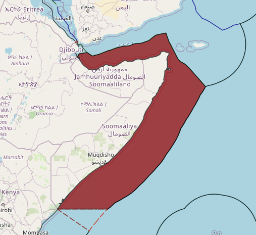
Somalia maritime claim about limits of the Exclusive Economic Zone
Maritime Claims, Somalia, Somalia continental shelf map, Somalia EEZ boundaries, Somalia Exclusive Economic Zone map, Somalia internal waters map, Somalia maritime boundaries, Somalia maritime claims, Somalia territorial waters map
View More Somalia maritime claim about limits of the Exclusive Economic Zone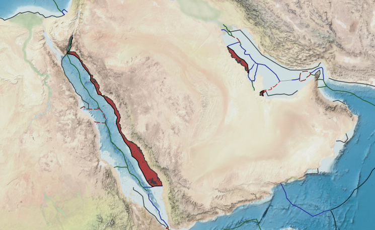
Saudi Arabia maritime claims about baselines of Saudi Arabia “in the Red Sea, the Gulf of Aqaba and the Persian Gulf”
Saudi Arabia, Saudi Arabia baseline claims, Saudi Arabia baseline in Gulf of Aqaba, Saudi Arabia baseline in Persian Gulf, Saudi Arabia baseline in Red sea, Saudi Arabia continental shelf map, Saudi Arabia EEZ map, Saudi Arabia internal waters map, Saudi Arabia maritime boundaries, Saudi Arabia maritime claims, Saudi Arabia straight baseline claims, Saudi Arabia territorial waters map
View More Saudi Arabia maritime claims about baselines of Saudi Arabia “in the Red Sea, the Gulf of Aqaba and the Persian Gulf”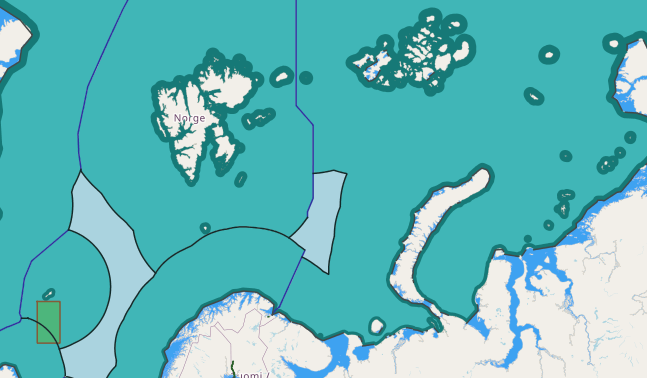
Russia maritime claims about the outer limits of its continental shelf beyond 200 nautical miles in respect to the Barents Sea
Barents Sea, Barents Sea continental shelf border, Barents Sea EEZ border, Barents Sea map, russia, Russia continental shelf map, Russia exclusive economic zone map, Russia internal waters map, Russia maritime boundaries, Russia maritime claims, Russia territorial waters map, russian federation
View More Russia maritime claims about the outer limits of its continental shelf beyond 200 nautical miles in respect to the Barents Sea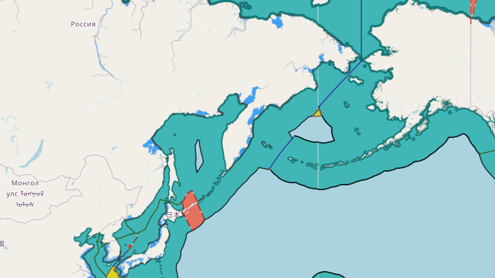
Russia maritime claims about the area of the continental shelf beyond 200 nautical miles in the region of the Sea of Okhotsk
continental shelf beyond 200 nautical miles in the region of the Sea of Okhotsk, Maritime Claims, russia, Russia continental shelf map, Russia exclusive economic zone map, Russia internal waters map, Russia maritime boundaries, Russia maritime claims, Russia territorial waters map, russian federation, Sea of Okhotsk
View More Russia maritime claims about the area of the continental shelf beyond 200 nautical miles in the region of the Sea of Okhotsk