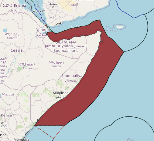
a list of geographical coordinates of points, pursuant to article 16, paragraph 2 and article 75, paragraph 2, of the Convention, which, inter alia, define the limits of the Exclusive Economic Zone of the Federal Republic of Somalia
The exclusive economic zone of Somalia covers 830,389 km2 in the Indian Ocean. It extends to a distance of 200 nautical miles from the baselines, from which the breadth of the nation’s territorial waters is measured. In accordance with Law No. 37 passed in 1972, Somalia’s EEZ falls under its territorial sovereignty.
On 9 February 1989, the Somali parliament ratified the United Nations Convention on the Law of the Sea (UNCLOS). The treaty defines the rights and responsibilities of nations with respect to their use of the world’s oceans, and establishes guidelines for businesses, the environment, and the management of marine Natural resources. The 1982 UNCLOS provides for a territorial sea of up to 12 nm and an EEZ of up to 200 nm. It also provides for the possibility of an extended continental shelf extending up to 350 nm from shore, depending on the characteristics of the seabed adjacent to the coast.
On 30 June 2014, President of Somalia Hasan Sheikh Mohamud outlined the exclusive economic zone of Somalia in relation to the Somali Maritime Law of 1988 passed by the Somali parliament. It stipulates that the Federal Republic of Somalia has:
Sovereign rights for the purpose of exploring and exploiting, conserving and managing the natural resources, whether living or non-living, of the seabed and subsoil and the superjacent waters, and with regard to other activities for the economic exploration and exploitation of the zone, such as the production of energy from water, currents and winds.


