Analyzing the Iran-Saudi Arabia Maritime Border Dispute The ongoing Iran-Saudi Arabia maritime border dispute has far-reaching geopolitical implications. An analytical examination of the conflicting claims reveals complex historical, legal, and economic factors that contribute to this volatile situation. Understanding the intricacies of this dispute is crucial for regional stability and international relations.
View More Analyzing the Iran-Saudi Arabia Maritime Border DisputeCategory: disputes(cases and legal aspects)
The noun dispute means any conflict or disagreement. The countries were in the middle of a border dispute; both sides claimed the toxic waste dump belonged to the other. As a verb, dispute can mean to quarrel or argue, but it can also mean to take exception to something.
Analyzing the Iran-Kuwait Maritime Border Dispute: A Professional Perspective
The ongoing maritime border dispute between Iran and Kuwait has remained a contentious issue for several decades, with both nations claiming ownership of a section of the Persian Gulf. This article aims to provide a comprehensive analysis of the dispute, examining the background, legal framework, historical context, key factors, past dispute resolution attempts, and potential implications for regional stability and global trade.
View More Analyzing the Iran-Kuwait Maritime Border Dispute: A Professional PerspectiveExploring the Honduras-Nicaragua Maritime Dispute
The maritime dispute between Honduras and Nicaragua is a long-standing and complex issue that has recently been addressed by the International Court of Justice (ICJ). This dispute, which concerns the delimitation of maritime borders between the two countries, has gained international attention due to the ongoing political implications. In this article, we will explore the background of the dispute, the precedent set by international law, the roles of international organizations, the specifics of the Honduras-Nicaragua maritime case, the political implications of the dispute, and possible ways of moving forward with a resolution.
View More Exploring the Honduras-Nicaragua Maritime Dispute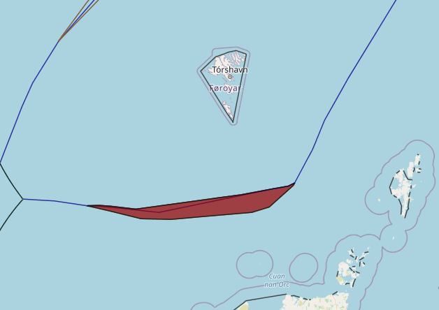
Denmark(Faroe Islands)–United Kingdom maritime boundary and Special Area
In May 1999 Denmark and the United Kingdom concluded an agreement (1999 Agreement) concerning their overlapping claims to fisheries zones and continental shelf in North Atlantic waters located between the Faroe Islands and Scotland. The 1999 Agreement designates continental shelf and fisheries zone boundaries in addition to a ‘Special Area’ of water column that remains subject to the overlapping jurisdictional claims both States.
View More Denmark(Faroe Islands)–United Kingdom maritime boundary and Special Area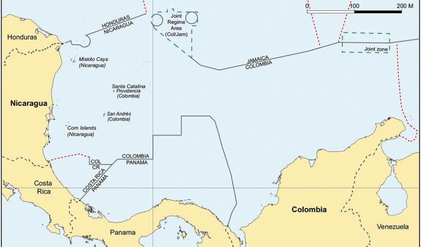
Colombia–Jamaica maritime boundary and the Joint Regime Area
In 1993 Colombia and Jamaica concluded a treaty (1993 Treaty) concerning their overlapping claims to a continental shelf and EEZ in the Caribbean Sea. Article 1 of the 1993 Treaty establishes a maritime boundary between the two States. Immediately to the west of the boundary, the 1993 Treaty also establishes a ‘Joint Regime Area’ in which, ‘pending the determination of the jurisdictional limits of each Party …, the Parties agree to establish … a zone of joint management, control, exploration and exploitation of living and non-living resources’. Article 3(1), sub-paragraphs (b) and (c) of the 1993 Treaty exclude two circular areas of 12 nautical miles radius from the Joint Regime Area. One circular area surrounds the cays of the Seranilla Bank and the other surrounds the cays of Bajo Nuevo. Both of these groups of features are claimed by Colombia – a claim that has been disputed on various occasions by Honduras, Jamaica, Nicaragua and the United States.
View More Colombia–Jamaica maritime boundary and the Joint Regime Area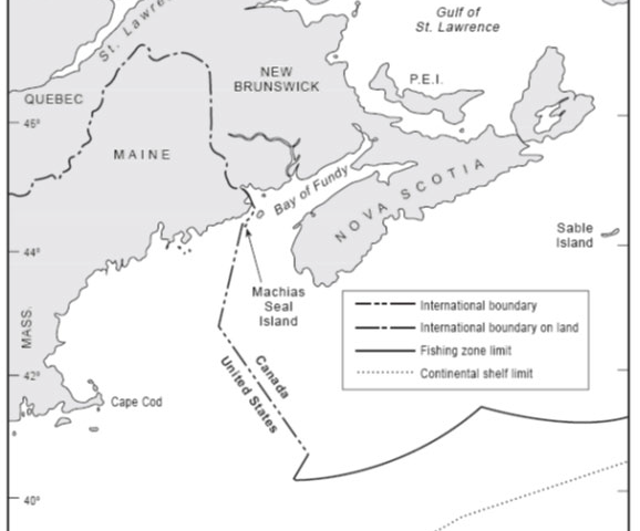
Canada–United States overlapping claims in North Atlantic and surrounding Machias Seal Island and North Rock
In 1979 the Canada and the United States agreed to empower a Chamber of the ICJ to designate a single seabed and water-column boundary in the Gulf of Maine. The Chamber’s 1984 Judgment establishes a segmented boundary that commences at an offshore point mutually agreed by both States (Point A) and terminates at the point of intersection with the United States’ 200 nautical mile limit. McDorman notes that, prior to the conclusion of the 1979 agreement, Canadian and US negotiators had proposed several options concerning provisional joint management of overlapping claims in the Gulf of Maine. These proposals did not gain traction because delimitation issues proved difficult to set aside. In particular, the location of competing boundary claims influenced political views concerning the fair division of fisheries and potential hydrocarbon resources.
View More Canada–United States overlapping claims in North Atlantic and surrounding Machias Seal Island and North Rock
Barbados–Guyana overlapping claims and Co-operation Zone in Atlantic ocean
Barbados and Guyana assert overlapping EEZ claims and continental shelf entitlements in an OCA located opposite the North East coast of continental South America. As discussed in the following paragraphs, the jurisdictional entitlements of Barbados and Guyana in this area are contested by Venezuela. Design features of provisional joint management frameworks:
View More Barbados–Guyana overlapping claims and Co-operation Zone in Atlantic ocean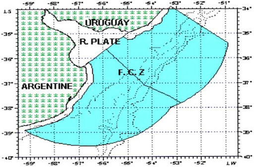
Argentina–Uruguay overlapping claims concerning boundary delimitation and the Río de la Plata
In 1973 Argentina and Uruguay concluded an agreement (1973 Agreement) concerning overlapping claims to the Río de la Plata and maritime zones seaward of a closing line at the mouth of the river. Seaward of the closing line, the 1973 Agreement establishes a ‘lateral maritime boundary’ and boundary of the continental shelf, which are both defined by a single equidistance line. The closing line and lateral maritime boundary are depicted in Figure. The lateral maritime boundary delimits several jurisdictional competencies recognized in the Agreement, which relate to: the exploration, conservation, and exploitation of resources; control and supervision of fishing activities; protection and preservation of the environment; scientific research; and construction and emplacement of installations. Viewing this delimitation of competencies in light of LOSC Part V, it is reasonable to regard the lateral maritime boundary as a delimitation of the EEZ and associated coastal state jurisdiction.
View More Argentina–Uruguay overlapping claims concerning boundary delimitation and the Río de la Plata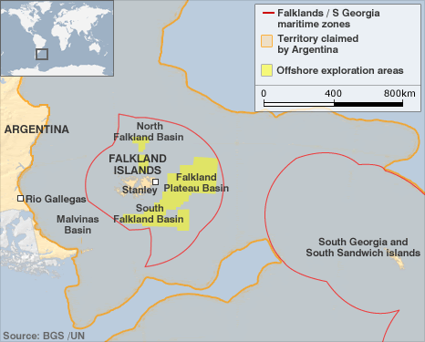
Argentina–United Kingdom: overlapping claims in the South Atlantic and Southern Oceans(Falkland/Malvinas Islands)
Argentina and the United Kingdom both claim sovereignty over the Falkland/Malvinas Islands, South Georgia and the South Sandwich Islands, and assert a variety of overlapping maritime claims appertaining to these South Atlantic features. Several features currently occupied and administered by the United Kingdom and were the focus of an armed conflict between the two States in 1982. In the immediate aftermath of the conflict the United Kingdom declared a 150 nautical mile ‘Falkland Island Protection Zone’ (FIPZ) designed to restrict and control the navigation of Argentinean vessels in waters surrounding the Islands. In 1986 the United Kingdom supplemented its 3 nautical mile territorial sea claim around the Falkland Islands by (1) declaring an ‘Interim Conservation and Management Zone’ (FICZ) projected 150 nautical miles from a fixed point located in the center of the Islands, and (2) reiterating its claim to the continental shelf surrounding the Islands.The limits of the FIPZ and FICZ are illustrated in Figure. The primary concern influencing the declaration of the FICZ was the rapid and unsustainable escalation of commercial fishing in waters surrounding the Islands between 1982 and 1986. The declaration of the FICZ and reiterated continental shelf claim prompted Argentina to issue a protest note reaffirming its sovereignty claim to the Islands and ‘its rights of sovereignty and jurisdiction over the surrounding maritime waters, sea-bed and marine sub-soil, rights which it will continue to exercise in its capacity as a coastal State in accordance with international law.’ In 1989 both States entered into negotiations with a view to normalizing diplomatic relations after they were broken off during the 1982 conflict. Design features of provisional joint management frameworks:
View More Argentina–United Kingdom: overlapping claims in the South Atlantic and Southern Oceans(Falkland/Malvinas Islands)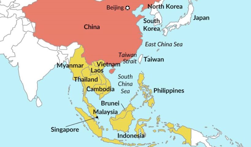
China geopolitical interests in eastern Asia and south china sea
The establishment of the People’s Republic of China (PRC) was proclaimed by Mao Zedong on October 1, 1949 at Tiananmen Square in Beijing. This followed two decades of almost constant turmoil that took the form of a prolonged civil war between the Nationalist Party, or Kuomintang (KMT), and the Chinese Communist Party (CCP) as well as the Japanese invasion of China, which resulted in the eight year Sino-Japanese War (1937–45). Following Chiang Kai-shek’s split with the CCP after his massacre of thousands of Communists in Shanghai in March 1927, the Nationalists were soon faced with a series of armed insurrections led by the Communists in cities such as Nanchang and Guangzhou. These uprisings ultimately proved unsuccessful. The Communists were driven into the countryside, where the Nationalists proceeded to wage a total of five campaigns of “extermination” between 1930 and 1934, aimed at achieving a comprehensive victory. The success of the fifth campaign in encircling and strangling the Communists led the latter to abandon their base in Jiangxi Province in October 1934 and stage the famous “Long March,” a 4,000-mile journey to establish a new base in Shaanxi in northwest China. China would soon be faced by the even greater threat of external invasion. The Japanese had established a presence in Manchuria by 1931. Growing domestic expansionist pressures led to an undeclared war with China following the “Marco Polo Bridge Incident” on July 7, 1937. Following the outbreak of hostilities, the Communists and Nationalists formed a “United Front” with the goal of defeating the Japanese, although the conflict between the CCP and the KMT was never resolved. Despite its initial success in taking many of the key coastal cities, including Shanghai, and eventually the Nationalist capital of Nanjing, the Japanese advance soon stalled. The Japanese army was never able to penetrate deep into the Chinese countryside. The Japanese surrender on August 14, 1945, following the dropping of atomic bombs on Hiroshima and Nagasaki, plunged China back into civil war. The Communists soon gained the upper hand, eventually driving the KMT out of China and into Taiwan, paving the way for the establishment of the People’s Republic of China.
View More China geopolitical interests in eastern Asia and south china sea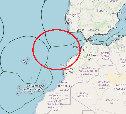
maritime boundaries between Portugal and morocco
morocco and Portugal doesn’t achieve to any agreement about maritime borders or boundaries yet. all their delimitation based on national legislation which is in connection to median line-equidistance system. their most subjects in maritime boundaries related to exclusive economic zone and continental shelf area. According to several Spanish media outlets, Morocco does not have the right to delimit its maritime borders without authorization from both Spanish and Portuguese authorities.
View More maritime boundaries between Portugal and morocco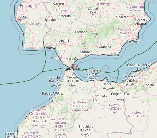
maritime boundaries between Spain and morocco
The pending maritime delimitations between Spain and Morocco are highly complex and noteworthy due to the existence of diverse factors, namely the particularity that the delimitations shall be conducted in two different seas: the Alboran Sea and the Atlantic Ocean. Moreover, various sovereignty issues must be addressed, such as the Spanish enclaves in North Africa, which are claimed by Morocco generating maritime entitlements, and the Western Sahara dispute and Morocco’s intention to include the Western Sahara maritime areas under its jurisdiction. In terms of the latter issue, this article studies the fisheries agreements concluded between the European Union and Morocco and the recent decisions given by the Court of Justice of the European Union, declaring those agreements prohibited under international law in respect of Western Sahara waters. Other significant matters analyzed are the views of both countries, the existence of several overlapping maritime claims with third States and the negotiations that have been carried out thus far to reach an agreement delimiting the maritime boundaries. On this subject, it is crucial to determine whether a tacit agreement exists – on the basis of the hydrocarbon activities licensed by Spain and Morocco – establishing the maritime boundary between the Canary Islands and Morocco’s Atlantic coast.
View More maritime boundaries between Spain and morocco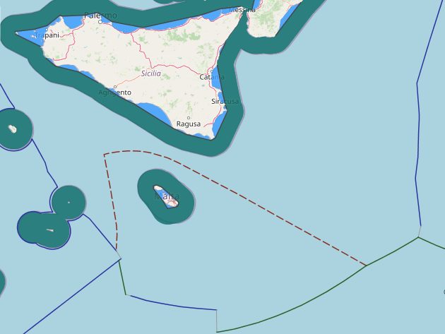
maritime boundaries between Italy and Malta
maritime boundaries between Italy and Malta,
View More maritime boundaries between Italy and Malta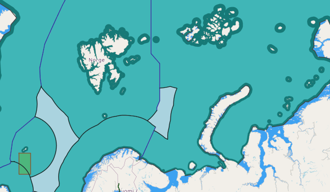
Russia maritime claims about the outer limits of its continental shelf beyond 200 nautical miles in respect to the Barents Sea
Barents Sea, Barents Sea continental shelf border, Barents Sea EEZ border, Barents Sea map, russia, Russia continental shelf map, Russia exclusive economic zone map, Russia internal waters map, Russia maritime boundaries, Russia maritime claims, Russia territorial waters map, russian federation
View More Russia maritime claims about the outer limits of its continental shelf beyond 200 nautical miles in respect to the Barents Sea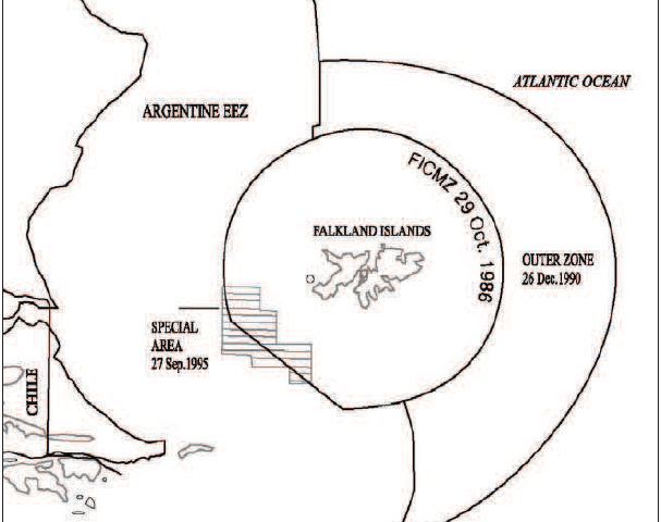
Practice on Provisional Arrangements in maritime Disputed Areas, JOINT DEVELOPMENT ZONES, United Kingdom-Argentina in the South West Atlantic case
Practice on Provisional Arrangements in maritime Disputed Areas, JOINT DEVELOPMENT ZONES, United Kingdom-Argentina in the South West Atlantic case, argentina, continental shelf, Falkland Islands, JOINT DEVELOPMENT ZONES, Madrid Formula, South West Atlantic, United kingdom
View More Practice on Provisional Arrangements in maritime Disputed Areas, JOINT DEVELOPMENT ZONES, United Kingdom-Argentina in the South West Atlantic case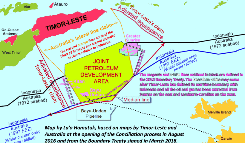
Practice on Provisional Arrangements in maritime Disputed Areas, JOINT DEVELOPMENT ZONES, Australia-Indonesia case
Practice on Provisional Arrangements in maritime Disputed Areas, JOINT DEVELOPMENT ZONES, Australia-Indonesia case, Australia, continental shelf boundaries, ibya/Malta Continental Shelf Case, Indonesia, JOINT DEVELOPMENT ZONES, median line, offshore areas of West Timor, Timor Gap, Timor Gap treaty, Treaty on the Zone of Co-operation in an Area between the Indonesian Province of East Timor and Northern Australia
View More Practice on Provisional Arrangements in maritime Disputed Areas, JOINT DEVELOPMENT ZONES, Australia-Indonesia case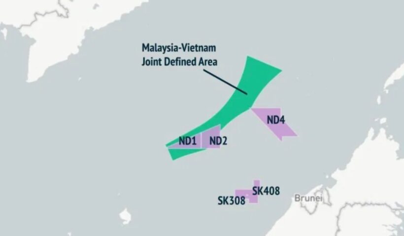
Practice on Provisional Arrangements in maritime Disputed Areas, JOINT DEVELOPMENT ZONES, Malaysia-Vietnam case
Practice on Provisional Arrangements in maritime Disputed Areas, JOINT DEVELOPMENT ZONES, Malaysia-Vietnam case, continental shelf, equidistant line, equidistant line between the coasts of the mainland of the two countries, Gulf of Thailand, Joint Development Zone, malaysia, Vietnam
View More Practice on Provisional Arrangements in maritime Disputed Areas, JOINT DEVELOPMENT ZONES, Malaysia-Vietnam case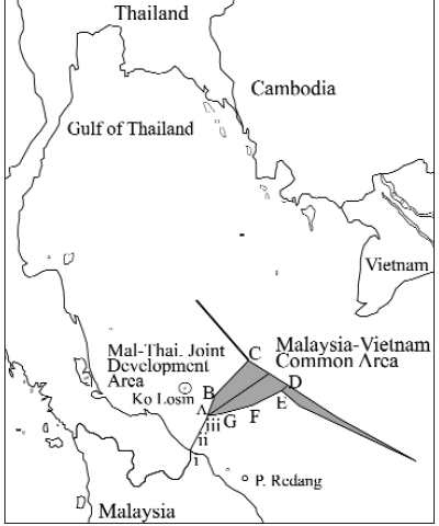
Practice on Provisional Arrangements in maritime Disputed Areas, JOINT DEVELOPMENT ZONES, Malaysia-Thailand case
Practice on Provisional Arrangements in maritime Disputed Areas, JOINT DEVELOPMENT ZONES, Malaysia-Thailand case, Continental Shelf Boundary, JOINT DEVELOPMENT ZONES, malaysia, Method of Shaping the Joint Development Zone, Thailand
View More Practice on Provisional Arrangements in maritime Disputed Areas, JOINT DEVELOPMENT ZONES, Malaysia-Thailand case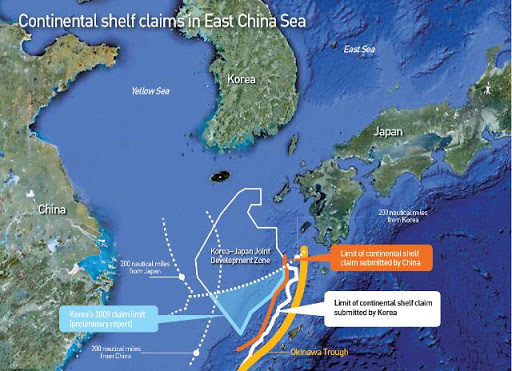
Practice on Provisional Arrangements in maritime Disputed Areas, JOINT DEVELOPMENT ZONES, KOREA AND JAPAN case
Practice on Provisional Arrangements in maritime Disputed Areas, JOINT DEVELOPMENT ZONES, KOREA AND JAPAN case, Continental Shelf Boundary, East China Sea, EEZ, EEZ boundary, EEZ fisheries zones, exclusive economic zone of Japan, exclusive economic zone of the Republic of Korea, flag State jurisdiction, Japan, JOINT DEVELOPMENT ZONES, Korea, KOREA AND JAPAN, Korea-Japan Fisheries Committee, Kyushu and Hokkaido of Japan, LOS Convention, Minquiers and Ecrehos Case, Peace line, provisional zones, Southern Bluefin Tuna Arbitration of 2000, UNCLOS I
View More Practice on Provisional Arrangements in maritime Disputed Areas, JOINT DEVELOPMENT ZONES, KOREA AND JAPAN case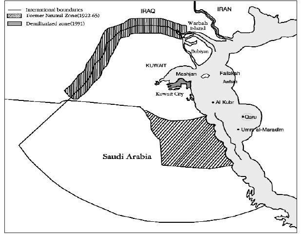
Practice on Provisional Arrangements in maritime Disputed Areas, JOINT DEVELOPMENT ZONES, Kuwait-Saudi Arabia case
Practice on Provisional Arrangements in maritime Disputed Areas, JOINT DEVELOPMENT ZONES, Kuwait-Saudi Arabia case, Al Uqair Protocol of 1922, American Independent Oil Company, JDZ, JOINT DEVELOPMENT ZONES, Kuwait, Kuwait-Saudi Arabia case, maritime Disputed Areas, Neutral Zone, Pacific Western Oil Corporation, Qarah island, Saudi Arabia, territorial sea
View More Practice on Provisional Arrangements in maritime Disputed Areas, JOINT DEVELOPMENT ZONES, Kuwait-Saudi Arabia case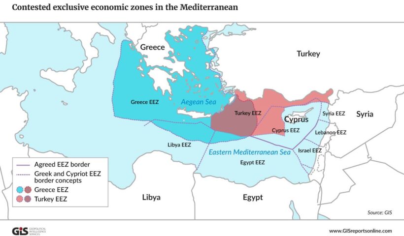
Can a Coastal State Conduct Marine Scientific Research in the Disputed Areas Without Consent from the Other Coastal State?
Can a Coastal State Conduct Marine Scientific Research in the Disputed Areas Without Consent from the Other Coastal State?, Aegean Sea Continental Shelf Case, Article 245 of the LOSC, Article 246 of the LOSC, Chinese exploration activities in the East China Sea, coastal State, East China Sea, exclusivity of knowledge, Greece, ICJ, ICSU, ILC, International Council of Scientific Union, International Law Commission, LOS Convention, Research in the Disputed Areas, sea-bed, sea-bed and subsoil of the continental shelf, seismic exploration, turkey
View More Can a Coastal State Conduct Marine Scientific Research in the Disputed Areas Without Consent from the Other Coastal State?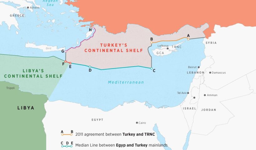
Can a Third State Conduct Marine Scientific Research in a Disputed Area Without Consent from Any of Two Coastal States?
Can a Third State Conduct Marine Scientific Research in a Disputed Area Without Consent from Any of Two Coastal States?, coastal States, marine scientific research by a third State, Third State Conduct Marine Scientific Research in a Disputed Area
View More Can a Third State Conduct Marine Scientific Research in a Disputed Area Without Consent from Any of Two Coastal States?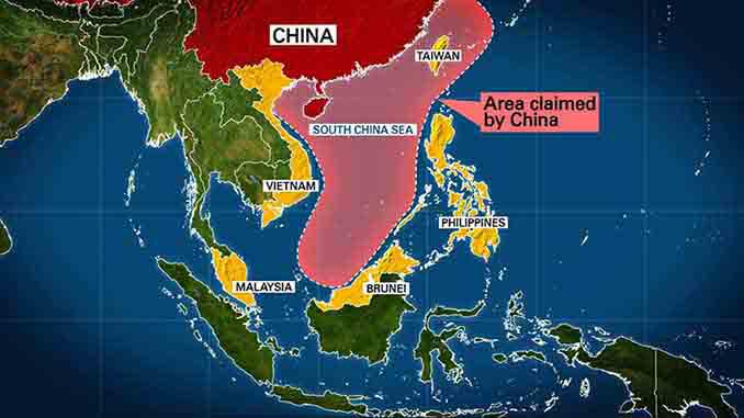
legal issues and marine laws of mainland China and Taiwan
legal issues and marine laws of mainland China and Taiwan, China, continental shelf, exclusive economic zone, LOS Convention, Taiwan, Yellow Sea
View More legal issues and marine laws of mainland China and Taiwan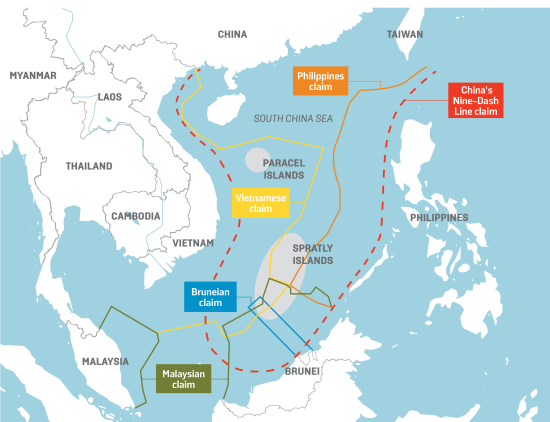
International Law in the South China Sea
International Law in the South China Sea, artificial islands, Commission on the Limits of the Continental Shelf, contiguous zone, continental shelf, Convention on the Continental Shelf, Convention on the High Seas, Convention on the Territorial Sea, EEZ, exclusive economic zone, internal waters, ISLANDS, low-tide elevations, maritime zones, rocks, south china sea, South China Sea dispute, UNCLOS I, UNCLOS II, UNCLOS III
View More International Law in the South China Sea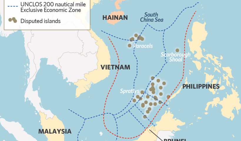
History of the South China Sea Disputes, facts and legal approach
History of the South China Sea Disputes, facts and legal approach, South China Sea Disputes
View More History of the South China Sea Disputes, facts and legal approach
ITLOS and its structure, duties, Composition,jurisdiction, competence and authorities
ITLOS and its structure, duties, Composition,jurisdiction, competence and authorities, International Tribunal for the Law of the Sea, ITLOS, United Nations Convention on the Law of the Sea
View More ITLOS and its structure, duties, Composition,jurisdiction, competence and authorities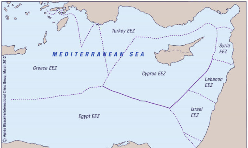
Legal Aspects of Inter-State Maritime Delimitation in the Eastern Mediterranean Basin
Legal Aspects of Inter-State Maritime Delimitation in the Eastern Mediterranean Basin, Are There Laws on the High Seas?, Can you do drugs in international waters?, Can you do whatever you want in international waters?, Definition of High Sea, freedom of high seas, High seas, high seas definition unclos, high seas map, high seas meaning, high seas meaning in business, high seas meaning in law, International waters, International Waters Laws, International waters map, Mare liberum, Territories & Zones, trans-boundary waters, What do you know about international waters?, What is legal in international waters?, What Laws Apply In International Waters?, Where are international waters?, Where are the high seas?, Where do international waters begin?, Why is it called high seas?
View More Legal Aspects of Inter-State Maritime Delimitation in the Eastern Mediterranean Basin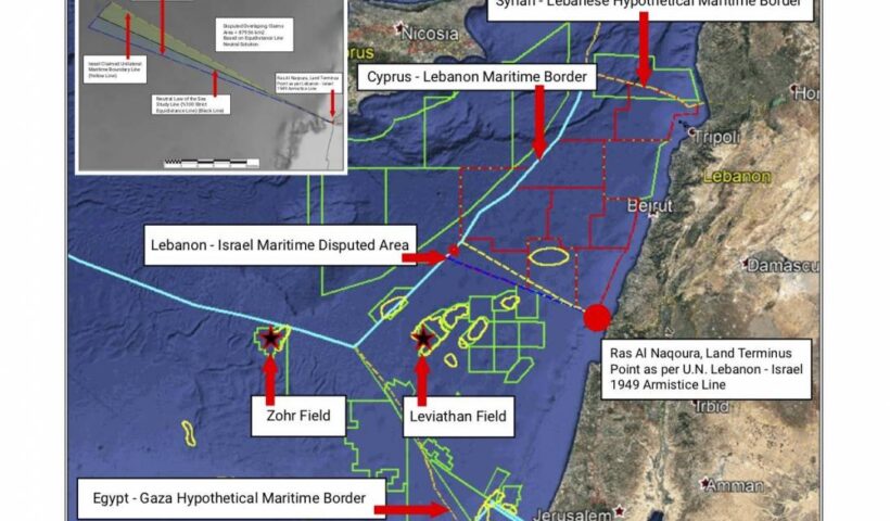
Israel-Lebanon Offshore Oil & Gas Dispute – Rules of International Maritime Law
Israel-Lebanon Offshore Oil & Gas Dispute – Rules of International Maritime Law,
View More Israel-Lebanon Offshore Oil & Gas Dispute – Rules of International Maritime Law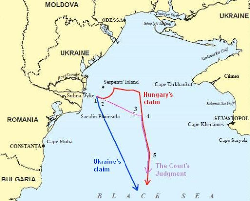
MARITIME DELIMITATION IN THE BLACK SEA
MARITIME DELIMITATION IN THE BLACK SEA, black sea, International Court of Justice, maritime delimitation, ukrine
View More MARITIME DELIMITATION IN THE BLACK SEA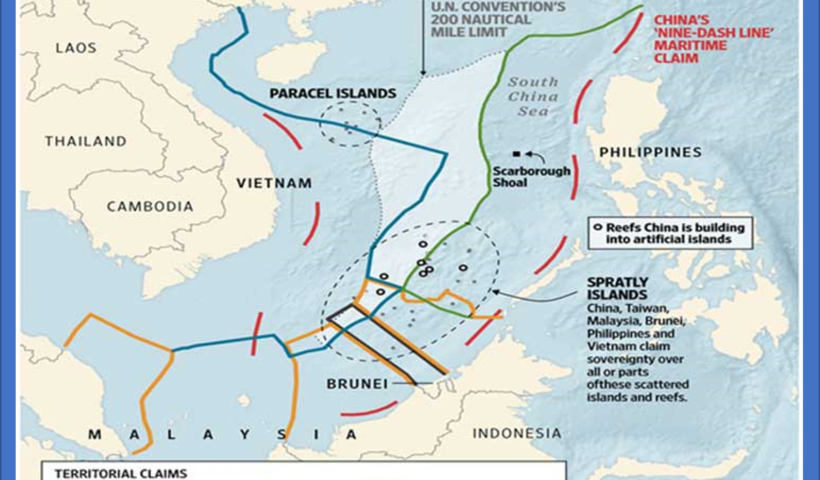
Maritime Boundary Disputes in the South China Sea International Legal Issues
Maritime Boundary Disputes in the South China Sea International Legal Issues, ICJ, legal issues, maritime boundary, maritime boundary dispute, south china sea
View More Maritime Boundary Disputes in the South China Sea International Legal Issues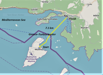
Aegean Territorial Waters Conflict An Evolutionary Narrative
Aegean Territorial Waters Conflict An Evolutionary Narrative, Aegean sea, continental shelf
View More Aegean Territorial Waters Conflict An Evolutionary Narrative
International Tribunal for the Law of the Sea (what and where?)
The International Tribunal for the Law of the Sea is an independent judicial body established by the United Nations Convention on the Law of the Sea to adjudicate disputes arising out of the interpretation and application of the Convention. The Tribunal is composed of 21 independent members, elected from among persons enjoying the highest reputation for fairness and integrity and of recognized competence in the field of the law of the sea.
View More International Tribunal for the Law of the Sea (what and where?)