MARITIME ZONE AND JURISDICTION
MARITIME ZONE AND JURISDICTION
Maritime Zones and How They Are Determined
Maritime zones are drawn using what the LOSC calls “baselines.” Unlike inland waters, coastal waters rise and fall in tides. Rather than having moving maritime boundaries, the baseline is fixed to begin at the low-water line along the coast. The low-water line is derived from the coastal State’s own charts.1
These zones are measured using nautical miles, a measurement based on the circumference of the Earth.2 One nautical mile equals roughly 1.15 miles on land.
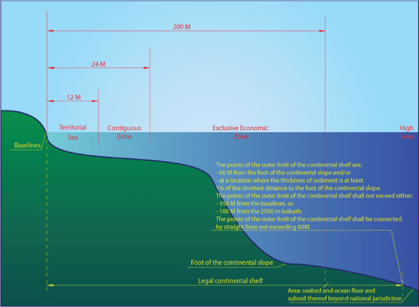
As seen in the graphic below, the LOSC divides the ocean into six different zones:
| 1. Internal Waters | 3. Contiguous Zone | 5. Continental Shelf |
| 2. Territorial Sea | 4. Exclusive Economic Zone | 6. High Seas & Deep Ocean Floor |
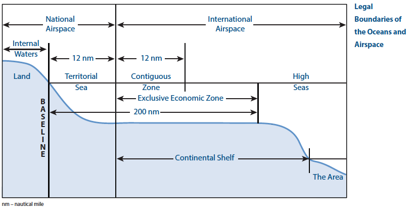
Internal Waters
Internal waters are all the waters that fall landward of the baseline, such as lakes, rivers, and tidewaters. States have the same sovereign jurisdiction over internal waters as they do over other territory. There is no right of innocent passage through internal waters.
Territorial Sea
Everything from the baseline to a limit not exceeding twelve miles is considered the State’s territorial sea. Territorial seas are the most straightforward zone. Much like internal waters, coastal States have sovereignty and jurisdiction over the territorial sea. These rights extend not only on the surface but also to the seabed and subsoil, as well as vertically to airspace. The vast majority of States have established territorial seas at the 12 nautical mile limit, but a handful have established shorter thresholds.
While territorial seas are subject to the exclusive jurisdiction of the coastal States, the coastal States’ rights are limited by the passage rights of other States, including innocent passage through the territorial sea and transit passage through international straits. This is the primary distinction between internal waters and territorial seas. These rights are described in detail in Chapter Three: Freedom of Navigation.
There is no right of innocent passage for aircraft flying through the airspace above the coastal state’s territorial sea.
Contiguous Zone
States may also establish a contiguous zone from the outer edge of the territorial seas to a maximum of 24 nautical miles from the baseline. This zone exists to bolster a State’s law enforcement capacity and prevent criminals from fleeing the territorial sea. Within the contiguous zone, a State has the right to both prevent and punish infringement of fiscal, immigration, sanitary, and customs laws within its territory and territorial sea. Unlike the territorial sea, the contiguous zone only gives jurisdiction to a State on the ocean’s surface and floor.3 It does not provide air and space rights.
Exclusive Economic Zone (EEZ)
Unlike other zones whose existence derived from earlier international law, the EEZ was a creation of the LOSC. States may claim an EEZ that extends 200 nautical miles from the baseline. In this zone, a coastal State has the exclusive right to exploit or conserve any resources found within the water, on the sea floor, or under the sea floor’s subsoil. These resources encompass both living resources, such as fish, and non-living resources, such as oil and natural gas.4 States also have exclusive rights to engage in offshore energy generation from the waves, currents, and wind within their EEZ. Article 56 also allows States to establish and use artificial islands, installations and structures, conduct marine scientific research, and protect and preserve the marine environment through Marine Protected Areas.5 Article 58 declares that Articles 88 to 115 of the Convention relating to high seas rights apply to the EEZ “in so far as they are not incompatible with this Part [V].”6
Due to the maritime features discussed later in this chapter, the U.S. has the largest EEZ in the world, totaling 3.4 million square nautical miles. The EEZ’s size derives from the large coastlines on the Atlantic Ocean, the Gulf of Mexico, the western continental U.S., Alaska, Hawaii and many small outlying Pacific islands. Although not a signatory of LOSC, The U.S. established an EEZ by Presidential Proclamation in 1983. EEZs of States worldwide constitute 38% of the oceans of earth that were considered part of the high seas prior to adoption of the LOSC.
The EEZ is the most misunderstood of all the maritime zones by policymakers in States around the world. Unlike the territorial sea and the contiguous zone, the EEZ only allows for the previously mentioned resource rights and the law enforcement capacity to protect those rights. It does not give a coastal State the right to prohibit or limit freedom of navigation or overflight, subject to very limited exceptions.
Continental Shelf
The continental shelf is a natural seaward extension of a land boundary. This seaward extension is geologically formed as the seabed slopes away from the coast, typically consisting of a gradual slope (the continental shelf proper), followed by a steep slope (the continental slope), and then a more gradual slope leading to the deep seabed floor. These three areas, collectively known as the continental margin, are rich in natural resources, including oil, natural gas and certain minerals.
The LOSC allows a State to conduct economic activities for a distance of 200 nautical miles from the baseline, or the continental margin where it extends beyond 200 nautical miles. There are two methods to determine the extent of a continental margin under the LOSC. The first method is by measuring geological features using what is called the Gardiner formula. By measuring the thickness of sedimentary rocks, the edge of the shelf is drawn where sedimentary rocks become less than 1 percent of the thickness of the soil. 7 The second method is to use fixed distances in what is called the Hedberg formula. This method allows States to draw its boundary 60 miles from the foot of the shelf’s slope.8 This expanded continental shelf cannot, however, exceed (i) 350 miles from the baseline or (ii) 100 miles from the 2,500-meter isobath.9
To prevent abuse of the continental shelf provisions, the LOSC established the Commission on the Limits of the Continental Shelf (CLCS). The CLCS uses scientists to evaluate States’ claims about the extent of their continental shelves and whether they conform to the Convention’s standards. The CLCS is discussed in more detail in Chapter Eight: The Arctic and the LOSC.
The economic rights within the continental shelf extend only to non-living resources and sedentary living resources, such as shellfish. It also allows the coastal State to build artificial islands, installations, and structures. Other States can harvest non- sedentary living resources, such as finfish; lay submarine cables and pipelines; and conduct marine research as if it were international waters (see below).10 As with the EEZ, continental shelf rights do not grant a State the right to restrict navigation.
High Seas and Deep Ocean Floor
The ocean surface and the water column beyond the EEZ are referred to as the high seas in the LOSC. Seabed beyond a coastal State’s EEZs and Continental Shelf claims is known under the LOSC as the Area. The LOSC states that the Area is considered “the common heritage of all mankind”12 and is beyond any national jurisdiction.
States can conduct activities in the Area so long as they are for peaceful purposes, such as transit, marine science, and undersea exploration.
Resources are a more complicated matter. Living resources, such as fish, are available for exploitation by any vessel from any State. Although the LOSC does not impose any limitations on fishing in the high seas, it encourages regional cooperation to conserve those resources and ensure their sustainability for future generations. The U.S. is party to separate conventions and regional fisheries management organizations that govern international fishing activity.
Non-living resources from the Area, which the LOSC refers to as minerals, are handled differently from fish, since mineral extraction projects are capital intensive to build and administer. To maintain such projects without national control, LOSC created the International Seabed Authority, referred to as the Authority in the LOSC document. This international body, headquartered in Jamaica, is responsible for administering these resource projects through a business unit called the Enterprise. The Enterprise was organized to be governed much like a public-traded corporation with a Council (functioning as an Executive Committee) and a Secretariat (which handles day-to-day administration). As an international body, the Authority also includes an Assembly of representatives from each nation which functions like a large Board of Directors. Unlike a publicly traded corporation, the Assembly is the supreme body for setting policy in the Authority. Since the ratification of the LOSC, there has been limited activity in relation to these provisions.13
Maritime Features
Although it is easy to determine how baselines can be drawn from large areas of continental coastline, such as in Florida or California, there are other maritime features that can affect how zones are drawn. These include:
Straight baselines (which are not a feature, but change the baseline when used)
River Mouths
Bays
Islands
Rocks
Reefs and Atolls
Low-Tide Elevations
Artificial Islands, Installations, and Structures
Straight Baselines
To accommodate deeply indented coastline and fringes of islands along the coast, the LOSC allows for use of straight baselines.14 These baselines, drawn between features and coastline to created straight lines, allow States to create fixed points to deal with the wild distance variances caused by such features. Any sea between the coast and the straight baseline is considered internal waters rather than territorial waters. The practical effect of straight baselines is that they push a State’s maritime borders outward. As a consequence, States ranging from Canada to China have aggressively used straight baselines in ways that are not accepted by the U.S.
States are not able to arbitrarily draw straight baselines in order to extend their maritime claims. The LOSC provides that straight baselines must conform to the general direction of the coast and the sea area lying with the lines must be closely linked to the coast.15 Straight baselines cannot be drawn across low-tide elevations (see definition below). Finally, they cannot be used to cut off another State’s access to their territorial sea or EEZ. Straight baselines can be considered in the case of “economic interest peculiar to the region concerned” if there is demonstrated “long usage” by the State drawing the baseline.16
River Mouths
River mouths are where rivers empty into the ocean. States with river mouths are permitted to draw a straight baseline between the low-water lines on each bank.17
Bays
Bays are one of the more complex maritime features. In general, a bay is a large indentation in a shoreline. This can become an issue with straight baselines as States may try to classify large bays as internal waters to project maritime boundaries out further and control overflight access. To prevent this, the LOSC defines a bay as a “well-marked indentation… [where] its area is as large as, or larger than, that of a semi-circle whose diameter is a line drawn across the mouth of that indentation.”18 The amount of control a State has over a bay is based on the distance between the low-water line on either side of the bay’s entrance. If the entrance is equal to or less than 24 miles wide at low-tide, then a State may draw a straight baseline across the entrance, effectively making the entire bay internal waters. If the entrance is more than 24 miles wide, a State can only draw a straight baseline 24 miles across the bay in a way that maximizes the area of internal waters. So-called “historic” bays, such as the Chesapeake Bay, are exempt from this provision.
Islands
Islands are naturally formed land areas surrounded by water on all sides. Islands must be above the water at high tide and able to sustain human habitation or economic life of their own.19 Islands possess the same maritime zones as other landmasses, including a territorial sea, contiguous zone, EEZ, and continental shelf. Islands do not need to be inhabited to create those maritime zones; they only need to be capable of sustaining human habitation or economic life. See below for information on artificial islands, which are treated differently than naturally occurring islands.
Rocks
A rock in the LOSC is defined as an island that is unable to support human habitation or economic life. Rocks provide their owners with less control than islands, providing only a territorial sea and a contiguous zone. They do not create or further the extent of an EEZ. Rock is a legal term and does not refer to any particular type of geological formation. For example, a sandbar can be considered a rock.
Reefs and Atolls
Reefs are formations of coral, roughly shaped like mountains, which run just below the surface of the water. Atolls are small, U-shaped islands or reefs which are made from coral. In the case of islands situated on atolls or of islands having fringing reefs, the baseline for measuring the breadth of the territorial sea is the seaward low-water line of the reef….20
Low-Tide Elevations
A low-tide elevation is a landmass that is completely submerged during high tide but above water at low tide. These elevations do not create any zones of maritime control on their own.21 If a low-tide elevation falls within the boundary of a State’s territorial sea as measured from the mainland or an island, that State may draw a baseline from the low-water line of the low-tide elevation rather than from the shore.
Artificial islands, Installations, and Structures
States have the right to construct artificial islands, installations and structures within their EEZ.22 Owners of such artificial features are permitted to establish reasonable safety zones, usually not to exceed 500 meters (1649 feet) or acceptable standards from international safety organizations such as the International Maritime Organization. Since they are not naturally occurring, artificial features do not create a territorial sea, contiguous zone, EEZ, or continental shelf.
Effects and Controversies of Maritime Zones and Features
The LOSC specifically defines the various maritime zones and features. However, there are ongoing controversies around the world over the definition of those features and the zones they should produce. It is easy to see why, depending on the type of feature.
The dispute over the Gulf of Sidra illustrates the challenges posed by bays and straight baselines. Located between the eastern and western halves of Libya, the Libyan government under Muammar Gadhafi in the 1970s attempted to draw a straight baseline across the Gulf of Sidra and declare it as internal waters.
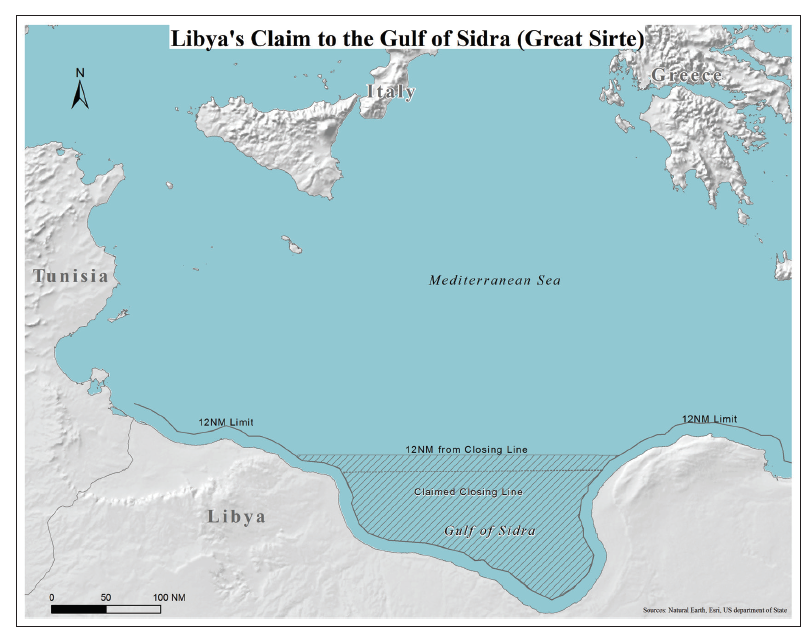
This would have allowed Libya a much larger area to restrict navigation and overflight. Most nations did not recognize the claim because, under the LOSC, the baseline did not conform to the shape of the coast. These nations also opposed Libya’s claim to historical use due to a lack of demonstrated usage and its large size.
Another challenge centers on the definition of islands. There is an incentive for States to obtain island status for their deep ocean features. Unlike rocks or low-water elevations, islands project a full territorial sea with overflight control and a full EEZ. This issue is most prevalent in the South China Sea, which is rich in resources and contains many maritime features that may or may not be islands entitled to large EEZs. Even small islands, such as the Spratly Islands, which total 1.5 square miles in size, can project hundreds of square nautical miles of exclusive economic control over the South China Sea.
Finally, rising sea levels threaten to alter the current demarcation of maritime zones. As already discussed, rocks and low-tide elevations create much smaller zones of control than islands. Rising sea levels could effectively downgrade the status of some islands to that of rocks or low-tide elevations that would deny their owners an EEZ. The LOSC provides no clear guidance on this emerging issue.
- United Nations Convention on the Law of the Sea, Article 5, Dec. 10, 1982, 1833 U.N.T.S. 397 [hereinafter LOSC]. (available at: http://www.un.org/ depts/los/convention_agreements/texts/unclos/part2.htm).
- US Department of Commerce, National Oceanic and Atmospheric Administration. “What is the difference between a nautical mile and a knot?” NOAA’s National Ocean Service. June 01, 2013. Accessed July 06, 2017. http://oceanservice.noaa.gov/facts/nauticalmile_knot.html.
- U.S. Department of the Navy, Annotated Supplement for the Commander’s Handbook on the Law of Naval Operations, NWP 9 (Rev. A)/FMFM 1-10), paras. 1.5.1 & 2.4.1 (1989).
- LOSC, Article 56
- LOSC, Article. 56.
- LOSC, Art. 58. (Articles 58-115 include the duty to render assistance (Article 98), actions taken to counter the slave trade (Article 99) and repress piracy (Articles 100-107), suppression of narcotics trafficking (Article 108), suppression of unauthorized broadcasting (Article 109), the exercise of the peacetime right of approach and visit (Article 110), and the right to hot pursuit (Article 111)).
- LOSC, Article 76(4)(a)(i).
- LOSC, Article 76 (4)(a)(ii).
- A 2,500-meter isobath means a line connecting the 2,500-meter depth of the seabed 10 LOSC, Article 79(1).
- LOSC, Article 78.
- LOSC, Article 136. 13 LOSC, Article 151(b). 14 LOSC, Article 7.
- LOSC, Article 7.
- LOSC, Article 7.
- LOSC, Article 9.
- LOSC, Article 10.
- LOSC, Article 121.
- LOSC, Article 6.
- LOSC, Article 13.
- LOSC, Article 60.