The Banda Sea is one of the most visited water bodies. Known forits clear waters, it is ideal for swimming and scuba-diving. The sea is surrounded by many islands and coral reefs too. Coming to geography, the Banda Sea lies near the Maluku islands, Indonesia.
the Banda Sea is just as overflowing with small creatures:prolific mandarinfish, frogfishes, seahorses, scorpionfishes, nudibranchs, and everything in between. Sometimes a quick trip from one side of an island to the other will turn a heart-pounding shark dive into a peaceful macro haven.
BahasaIndonesiaLaut Banda, portion of the western South Pacific Ocean, bounded by the southern islands of the Moluccas of Indonesia (Alor, Timor, Wetar, Babar, Tanimbar, and Kai on the south and Ceram, Buru, and Sula on the north). The Banda Sea (Indonesian: Laut Banda, Portuguese: Mar de Banda, Tetum: Tasi Banda) is one of four seas that surround the Maluku Islands of Indonesia, connected to the Pacific Ocean, but surrounded by hundreds of islands, including Timor, as well as the Halmahera and Ceram Seas. It is about 1000 km (600 mi) east to west, and about 500 km (300 mi) north to south.
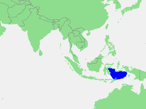
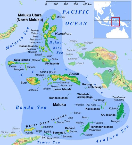
Islands bordering the Banda Sea include Sulawesi to the west, Buru, Ambon Island, Seram, Aru Islands, Barat Daya Islands, to the Tanimbar Islands, the Kai Islands and Timor in the East. Although the borders of the sea are hazardous to navigation, with many small rocky islands, the middle of the sea is relatively open. Island groups within the sea include the Banda Islands. A number of islands in the Banda Sea are active volcanoes including Gunung Api and Manuk in the Banda Islands.
Plate tectonic activities in Banda Sea
Map of the Banda Sea Plate
The Banda arc is famous for its 180° curvature and is, in Timor, generally agreed to be the product of collision between a volcanic arc and the Australian continental margin. The Banda Sea occupies the main portion of the Banda Sea Plate. The southern margin of the sea consists of island arcs above subduction zones. To the east of the Sunda Trench is the Timor Trough which lies south of Timor, the Tanimbar Trough south of the Tanimbar Islands and the Aru Trough east of the Aru Islands. These trenches are the subduction zone of the Indo-Australian plate beneath the Banda Sea Plate, where the Indo-Australian Plate moves northwards. Fore-arc sediments progressively carried northwards by the Indo-Australian Plate have been folded and faulted forming Timor island. To the northeast lies Seram Island which overlies the subduction of the Bird’s Head Plate of West Papua. The deepest point of the sea, Weber Deep, is an exposed oceanic fault and the world’s deepest forearc basin, with depth more than 7.2 kilometres (4.5 mi).
Earthquakes
The USS George Washington crossing the Banda Sea
Earthquakes are very frequent in the area, due to the confluence of three tectonic plates – Eurasian, Pacific and Indo-Australian plates.
1852 Banda Sea earthquake
1938 Banda Sea earthquake
2006 Banda Sea earthquake
The Banda Sea is a marine ecoregion, as defined by the World Wildlife Fund. It is part of the Coral Triangle region, which has the greatest diversity of coral reef species in the broader Indo-Pacific.
The islands surrounding the Banda Sea are part of Wallacea, a biogeographical region that contains the islands lying between Asia and Australia which haven’t been joined to either continent. The islands of Wallacea are home to a mix of plant and animal species from both tropical Asia (the Indomalayan realm) and the Australasian realm which includes Australia and New Guinea.
The islands are divided among several terrestrial ecoregions. The northern islands of Sulawesi, Buru, and Seram constitute separate tropical moist forest ecoregions. The islands south of the Banda Sea are among the driest in Indonesia, and are home to tropical dry forests. The Timor and Wetar deciduous forests ecoregion includes Timor and Wetar. The Lesser Sunda Islands from Alor through Flores and Sumbawa to Lombok constitute the Lesser Sundas deciduous forests ecoregion.
The Tanimbar Islands, Kai Islands, and Barat Daya Islands (except for Wetar) in the southeastern Banda Sea form the Banda Sea Islands moist deciduous forests ecoregion. These islands are covered in mostly-intact rain forest, and home to a number of endemic plants and animals including twenty-one bird species, a very high number for this small ecoregion. There are only twenty-two native mammals on these islands, including the rare dusky pademelon (Thylogale brunii) and Indonesian tomb bat (Taphozous achates), and the endangered endemic Kei myotis bat (Myotis stalkeri). The birdlife is threatened by egg collectors and even more by cats and rodents that have been introduced to the islands. Yamdena in the Tanimbar Islands is an example of a large and fairly unspoilt habitat and is a protected area. The base for visiting these islands is by plane or ship from Ambon Island to the north. The Banda and Kai Islands, although remote, are visited by tourists for snorkelling and for their unspoilt beaches. Various cetacean species have been recorded including either or both blue and pygmy blue whales and Omura’s whales.