Named after the Scottish National Antarctic Expedition (1902–1904) vessel Scotia, under the command of William S. Bruce, the Scotia Sea has a lengthy record of exploration dating back to the 17th century.
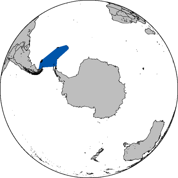
The Scotia Sea is a sea located at the northern edge of the Southern Ocean at its boundary with the South Atlantic Ocean. It is bounded on the west by the Drake Passage and on the north, east, and south by the Scotia Arc, an undersea ridge and island arc system supporting various islands. The sea sits atop the Scotia Plate. It is named after the expedition ship Scotia. Many icebergs melt there.
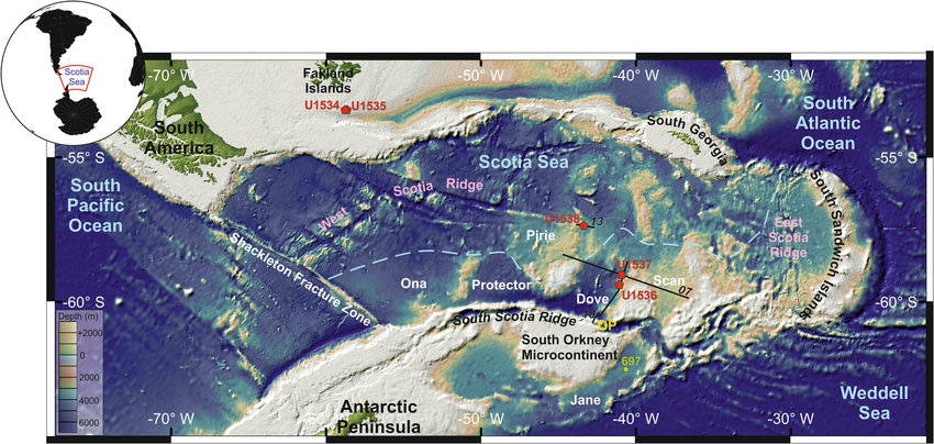
The Scotia Sea is the area of water between the Drake Passage, Tierra del Fuego, South Georgia and the South Sandwich Islands, the South Orkney Islands and the Antarctic Peninsula. The Scotia Arc is an undersea ridge and island arc bordering the Scotia Sea.
The Scotia Sea is an ocean region of approximately 900,000 sq km (347,500 sq mi) that is located between the South Atlantic Ocean and the Southern Ocean which surrounds Antarctica.
Named after the expedition ship Scotia, which explored the waters between 1902 and 1904, it comprises the area of water between the Drake Passage, Tierra del Fuego, South Georgia and the South Sandwich Islands, the South Orkney Islands and the Antarctic Peninsula.
The Scotia Sea is bounded on the west by the Drake Passage and on the north, east and south by the Scotia Arc, a submarine ridge which sits atop the Scotia Plate.
The Scotia Sea is the area of water between the Drake Passage, Tierra del Fuego, South Georgia, the South Sandwich Islands, the South Orkney Islands, and the Antarctic Peninsula. These island groups all sit atop the Scotia Arc, which frames the sea on the north, east, and south. The Scotia Sea covers an area around 900,000 km2 (347,500 sq mi). About half of the sea stands above the continental shelf.
The islands bordering the Scotia Sea are rocky and partly covered in ice and snow year round. These areas support tundra vegetation consisting of mosses, lichens and algae. Seabirds, penguins and seals feed in the surrounding waters.
Seabirds include four species of albatross: black-browed albatross (Diomedea melanophris), grey-headed albatross (Thalassarche chrysostoma), light-mantled albatross (Phoebetria palpebrata) and wandering albatross (Diomedea exulans).
Only five species of birds remain on land on the islands and these include an endemic race of the yellow-billed pintail duck (Anas georgica) and the endemic South Georgia pipit (Anthus antarcticus). Other birds include the southern giant petrel, with sizeable colonies on Bird Island.
Penguin species found here include large numbers of king penguins on South Georgia especially, as well as chinstrap penguin, macaroni penguin, gentoo penguin, Adelie penguin and rockhopper penguin (Eudyptes chrysocome).
Seals include the Antarctic fur seal (Arctocephalus gazella) and sub-Antarctic fur seal (Arctocephalus tropicalis) in large numbers, leopard seal (Hydrurga leptonyx), Weddell seal (Leptonychotes weddellii), the huge southern elephant seal (Mirounga leonina) and crabeater seal (Lobodon carcinophagus).
The Scotia Sea Islands tundra is a tundra ecoregion (WWF AN1103) which includes several island groups – South Georgia and the South Sandwich Islands, South Shetland Islands, and Bouvet Island – in the Scotia Sea, where the South Atlantic Ocean meets the Southern Ocean.
Scotia Arc
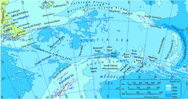
Formed by continental fragments that once formed a land bridge between South America and Antarctica, the Scotia Arc (also known as the Scotia Ridge) is an undersea ridge and island arc forming the north, east and south border of the Scotia Sea. It also surrounds the small Scotia and South Sandwich tectonic plates.
The northern border, known as the North Scotia Ridge, comprises (from west to east) Isla de los Estados at the tip of Tierra del Fuego, the Burdwood, Davis and Aurora Banks; the Shag, South Georgia Island and Clerke Rocks.
The eastern border comprises the volcanic South Sandwich Islands flanked by the South Sandwich Trench.
The southern border, known as the South Scotia Ridge, comprises (from east to west) Herdman, Discovery, Bruce, Pirie and Jane Banks; the South Orkney Islands and Elephant Island.
The Bransfield Strait separates the Scotia Arc from the South Shetland Islands and James Ross Island which flank the tip of the Antarctic Peninsula.
With an active volcanic arc-trench system at its eastern end, the Scotia Arc compares geologically to the similar Lesser Antilles Volcanic Arc in the Caribbean Sea. The Scotia Ridge region was thus given the name “Southern Antilles” by the early geologists Eduard Suess and Otto Nordenskjöld.
The Scotia Arc forms a discontinuous link between South America and Antarctica. Today, it is considered a continuation of the Andes and the antarctic part of the mountain range is called Antarctandes. It is also an important barrier between the Pacific and Atlantic Oceans and therefore for the Antarctic Circumpolar Current.
The northern arm of the Scotia Ridge, including South Georgia, lies in the sub-Antarctic climatic zone, and the southern arm, south of the Antarctic Convergence, lies in the cold Antarctic zone. The biota varies accordingly. South Georgia supports a rich tundralike flora with at least 50 species of vascular plants, whereas islands in the Antarctic zone, including the South Orkneys and South Shetlands, can maintain only primitive communities of mainly seedless plants, such as lichens, mosses, and algae. Many species of birds, mostly sea and a few shore birds and land birds, including petrels, penguins, gulls, terns, skuas, and sheathbills, inhabit these regions. Other sea life south of the Convergence includes nearly 100 species of fish and several species of whales and seals. Human predation has seriously reduced the sea mammal population, some species being almost at the point of extinction. The accidental introduction of cats, dogs, mice, and rats threatens bird nesting grounds on some islands in the Scotia Sea.