Caribbean Sea, Arm of the Atlantic Ocean. It covers about 1,063,000 sq mi (2,753,000 sq km) and washes the northern coast of South America, eastern Central America, and eastern Mexico. The Caribbean Sea is home to the second-largest barrier reef in the world, the Mesoamerican Barrier Reef, and the largest reef system in the Northern Hemisphere. It runs 620 miles along the coasts of Mexico, Belize, Guatemala, and Honduras.
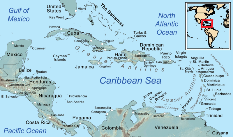
The Caribbean Sea (Spanish: Mar Caribe; French: Mer des Caraïbes; Haitian Creole: Lanmè Karayib; Jamaican Patois: Kiaribiyan Sii; Dutch: Caraïbische Zee; Papiamento: Laman Karibe) is a sea of the Atlantic Ocean in the tropics of the Western Hemisphere. It is bounded by Mexico and Central America to the west and southwest, to the north by the Greater Antilles starting with Cuba, to the east by the Lesser Antilles, and to the south by the northern coast of South America. The Gulf of Mexico lies to the northwest.
The entire area of the Caribbean Sea, the numerous islands of the West Indies, and adjacent coasts are collectively known as the Caribbean. The Caribbean Sea is one of the largest seas and has an area of about 2,754,000 km2 (1,063,000 sq mi).
The name Caribbean derives from the Caribs, one of the region’s dominant Native American groups at the time of European contact during the late 15th century. After Christopher Columbus landed in the Bahamas in 1492, the Spanish term Antillas applied to the lands; stemming from this, Sea of the Antilles became a common alternative name for “Caribbean Sea” in various European languages. During the first century of European colonization, Spanish dominance in the region remained undisputed.
From the 16th century, Europeans visiting the Caribbean region distinguished the “South Sea” (the Pacific Ocean south of the isthmus of Panama) from the “North Sea” (the Caribbean Sea north of the same isthmus).
The International Hydrographic Organization defines the limits of the Caribbean Sea as follows:
On the North. In the Windward Channel – a line joining Caleta Point (74°15′W) and Pearl Point (19°40′N) in Haiti. In the Mona Passage – a line joining Cape Engaño and the extreme of Agujereada (18°31′N 67°08′W) in Puerto Rico.
Coral reefs in the British Virgin Islands
Eastern limits. From Point San Diego (Puerto Rico) Northward along the meridian thereof (65°39′W) to the 100-fathom line, thence Eastward and Southward, in such a manner that all islands, shoals and narrow waters of the Lesser Antilles are included in the Caribbean Sea as far as Galera Point (Northeast extremity of the island of Trinidad). From Galera Point through Trinidad to Galeota Point (Southeast extreme) and thence to Baja Point (9°32′N 61°0′W) in Venezuela.
Note that, although Barbados is an island on the same continental shelf, it is considered to be in the Atlantic Ocean rather than the Caribbean Sea.
What are facts about the Caribbean sea?
- It’s technically part of the Atlantic Ocean. …
- It takes its name from the natives who lived there. …
- 9% of the world’s coral reefs are in the Caribbean Sea. …
- It’s home to diverse flora and fauna. …
- It’s the deepest sea in the world. …
- It includes over 7,000 islands.
What are countries located in the Caribbean sea?
- Antigua and Barbuda.
- Belize.
- Dominica.
- Dominican Republic.
- Grenada.
- Guyana.
- Haiti.
- Jamaica.
The name “Caribbean” is derived from the Caribs, one of the dominant American Indian groups in the region at the time of European contact during the late 15th century. The Caribbean Sea, like other tropical ocean regions, contains warm, clear water. The water is clear due to the absence of plankton and suspended particles.
The Caribbean is such a light a shade of blue due to the tendency of the Caribbean coast to scatter sunlight. The fact that the sand is light colored and the water is relatively shallow also makes the water appear turquoise. The Caribbean Sea is home to about 450 species, including sharks, flying fish, rays and morays. 90 species represent the region’s mammals: sperm whales, humpback whales, stingrays and dolphins can be found in the sea. American manatees and seals are located off the coast of Jamaica.
What is the Caribbean best known for?
Known for idyllic beaches and sparkling turquoise seas, the Caribbean is a popular destination for sun-seekers in search of a tropical escape.
How many countries are in the Caribbean sea?
Of the sixteen independent countries in the Caribbean, only eight are republics. This includes Barbados, Cuba, Dominica, Dominican Republic, Guyana, Haiti, Suriname, and Trinidad & Tobago.
Is Caribbean Sea in danger?
The data shows that the sea and marine ecosystems are being degraded from marine pollution, acidification, and rising sea temperatures. Coral reef degradation is another dangerous threat to the natural capital of the Caribbean, with an estimated annual revenue loss of between US$350 million and US$870 million.
Cuba is the largest island country in the Caribbean sea, with a total area of almost 111 thousand square kilometers, followed by the Dominican Republic, with nearly 49 thousand square kilometers. There are six official languages spoken in the Caribbean and many more unofficial languages. Among the official languages are Dutch, English, French, Haitian Creole, Papiamentu, and Spanish. Two of these official languages, Haitian Creole and Papiamentu, are Creole languages.
It’s become commonplace to refer to people from the Caribbean/West Indies as Caribbeans, Caribbeaners, even Antillians, in addition to the historical label of West Indians. More recently Afro-Caribbean and African-Caribbean have been added to the lexicon, to describe those who are of African descent.
Is Caribbean a rich country?
Rich Caribbean countries have been a magnet attracting HNWI and millionaires. Bermuda, Cayman and British virgin islands are the top richest and wealthiest islands in the caribbean.
What is the most beautiful Caribbean?
St. Lucia is arguably the most beautiful of all Caribbean Islands with its two UNESCO World Heritage designated Pitons standing proud. The Gros and Petit Pitons are two mountainous volcanic plugs that definitely contribute to the island’s beauty.
What are the four largest Caribbean countries?
Greater Antilles, the four largest islands of the Antilles (q.v.)—Cuba, Hispaniola, Jamaica, and Puerto Rico—lying north of the Lesser Antilles chain. They constitute nearly 90 percent of the total land area of the entire West Indies.
Which country has only a Caribbean coast? Belize
The Pacific Ocean borders Central America to the west, and the Caribbean Sea borders these countries to the east. While most of the republics have both a Caribbean and a Pacific coastline, Belize has only a Caribbean coast, and El Salvador has only a Pacific coast.
Is the Caribbean sea cold?
The water of the Caribbean is warm, clear and has lower salinity levels than the neighbouring Atlantic. The average water temperature is around 27°C (80°F) and varies as little as 3°C (37°F) throughout the year.
Can a tsunami hit the Caribbean?
The historical record suggests that potentially destructive tsunamis occur at an average rate of 1-2 per century in the Caribbean. The hazard is not the same throughout the islands. The north-eastern Caribbean region near Puerto Rico and Hispaniola is more susceptible to tsunamis.
Do I need a passport to go to the Caribbean?
For visiting the Caribbean islands, a passport is required and it needs to be valid for travel. You may also require a visa for the Caribbean islands, depending upon the country of issue of your passport. You must check to be sure “do I need a visa” to enter my destination country.
Who owned the Caribbean islands?
The four main colonial powers in the Caribbean were the Spanish, English, Dutch, and French. Other countries that held possession of various islands at different times were Portugal, Sweden, and Denmark.
Which Caribbean country has most Muslims?
Suriname has the highest percentage of Muslims in its population for the region, with 13.9% or 75,053 individuals, according to its 2012 census.